


Agricultural News
Just Over Half of Oklahoma Remains in Exceptional Drought in Latest National Monitor- See the Graphic
Thu, 27 Oct 2011 20:10:01 CDT
 Rainfall over the last twenty fours across Oklahoma has brought an inch of rain or more on a widespread basis from southwestern Oklahoma Counties across Central Oklahoma and the Oklahoma City metro on into east central and portions of northeast Oklahoma.
Each of those is another chink in the drought's armor. In and of themselves, they may not create widespread relief. They do weaken the drought's hold on the state, however, and create the opportunities for future rains to bring that widespread relief. As we've mentioned many times, drought relief does not always occur with the bigtime events (e.g., October 1941 ending the Dust Bowl drought with the wettest month in state history, or ending the 1950s drought with the wettest year in state history -- 1957). If this drought dies the death of a thousand cuts, it will still be dead.
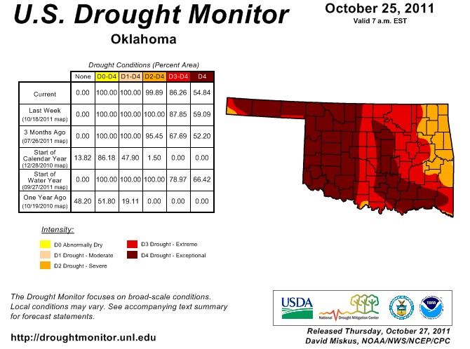
Rainfall amounts have been much less in all of the northernmost counties across the top of the state. However, earlier rains this month have helped in a further reduction in the latest Drought Monitor for the state of Oklahoma. The Drought Monitor was released this morning and shows that 54% of the state remains in Exceptional Drought, a number that does not take into account these latest rains. The U.S. Drought Monitor continues to add improvements with each event. The map released this morning indicates our area of exceptional (D4) drought decreased by about four percent this week, and we even had a splotch of severe (D2) drought in far south central Oklahoma. Improvements due to the current rainfall will not show up until next Thursday's map.
The latest Drought Monitor for Oklahoma is pictured above. To view the national Drought Monitor picture- click here.
WebReadyTM Powered by WireReady® NSI
Top Agricultural News
More Headlines...


