


Agricultural News
Rainfall- Who Got It and Who Did Not? The Latest Graphic From the Mesonet
Mon, 15 Oct 2012 05:42:46 CDT
 Rainfall across the state of Oklahoma over this past weekend left many locations with amounts of rain that exceeded an inch of much needed moisture- while large amounts of west central and southwest Oklahoma got little or no rain from this multi day event.
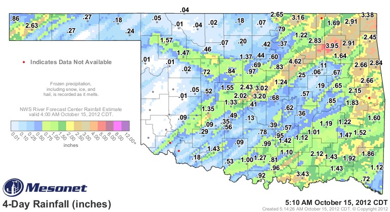
The graphic above from the Oklahoma Mesonet shows Oilton (between Stillwater and Tulsa) with 4.62 inches of rain since last Thursday- the most of any location- and it reports Boise City in Cimarron County as one of the winners, with 2.63 inches of rainfall from this system.
According to Alan Crone with the News on 6 in Tulsa, the weather system that will be rolling through our region offers little to no chance of rain in the western two thirds of the state- Alan says in his Monday morning blog that we can look for "high pressure dominating the area today and a fast moving clipper sliding across the area Wednesday. Low level moisture will be lacking, but a few isolated showers or storms may be possible Wednesday afternoon across extreme eastern OK. The higher chances should occur across Western Arkansas and locations eastward where some strong to near severe storms will be possible." Click here to read his full update for this Monday morning.
The Oklahoma City National Weather Service Forecast Discussion shows little opportunity for precipitation across most of Oklahoma this week- for those that received rain from this past weekend- that will give plenty of opportunity for finishing up wheat seeding- for those that missed the rains of the last few days- that just means more days of dry weather strung together.
WebReadyTM Powered by WireReady® NSI
Top Agricultural News
More Headlines...


