


Agricultural News
Rainfall Totals as of Wednesday Morning- January 30- Take a Look
Wed, 30 Jan 2013 05:04:33 CST
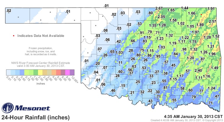 Oklahoma rainfall totals turned out to be impressive across a broad section of north central and eastern Oklahoma in an end of the month storm system that looked and felt more like springtime than mid winter. Three of the most impressive rainfall totals that can be seen in the graphic above include Newkirk in Kay County with 2.67 inches of rain, Jay with 2.57 inches and Wilburton (southeastern Oklahoma) with 2.4 inches of rainfall. Burbank- not far from Newkirk- was the fourth Mesonet location across the state that topped the two inch level for rainfall in this system.
Many of the northcentral locations were among the driest in the state of Oklahoma before this storm- so the rainfall was especially welcome in those locations. While much of the winter wheat and winter canola locations in the state missed the larger rainfall totals- some locales west of Oklahoma City grabbed decent amounts of rainfall for this winter system- Hinton checked in with an inch while Chickasha, Apache and Weatherford all got six tenths.
Gary McManus- Associate State Climatologist for Oklahoma- says it appears the next rain making system for the state may be a week away- but for those that got this rainfall- they are feeling blessed on this next to last day of the month of January.
To view the real time ongoing snapshot of rainfall across the state in recent days- click here for the three day rainfall total map from the Mesonet which will allow you to roll your mouse over the location to see the name of the station.
WebReadyTM Powered by WireReady® NSI
Top Agricultural News
More Headlines...


