


Agricultural News
Rainfall Totals Exceed An Inch in Most of Oklahoma Last Week-Rainfall and Snow Already Here- Latest Graphics Updated
Mon, 25 Feb 2013 04:20:13 CST
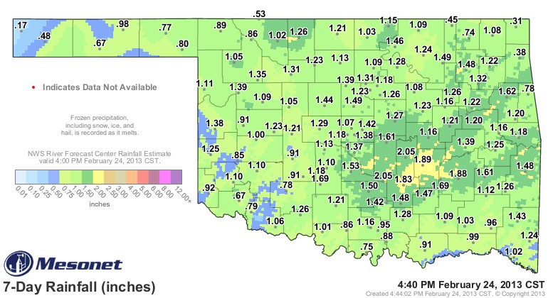 Oklahoma- at least most of the state- got a really nice soaking over this past week from the combination of snow, ice and rain that fell across the state. Only the western half of the Panhandle and the far northeastern corner of Oklahoma got less than the one inch plus that most Mesonet stations received. The graphic above shows the widespread inch plus rainfall totals for the past seven days which catches the storm of this past week- and includes the snow that initially was not counted as liquid precipitation.
Two Mesonet stations- Byars and Bowlegs- exceeded the two inch precipitation level in the storm of this past week.
Meanwhile, the state braces for another major west coast storm system lining up to hit the southern plains. This winter storm is on track to impact Oklahoma beginning Sunday night through Tuesday morning.
A Blizzard Warning is in effect for all of western Oklahoma from Sunday evening through early Tuesday morning. Conditions here will start worsening overnight tonight into Monday morning. Precipitation will initially begin as snow before a quick transition to heavy, blowing/drifting snow. Expect sustained winds at 20 to 40 mph with gusts potentially to 50 mph creating white-out conditions with little visibility.
A Winter Storm Warning is in effect for central and north-central Oklahoma overnight tonight through Tuesday morning. Precipitation in central Oklahoma will begin after midnight Monday morning as rain, with a few thunderstorms possible. The transition to snow won't be as fast and will wait until early Monday afternoon to take place. Once the precipitation changes to snow, winds will increase out of the north at 20-40 mph, causing blowing/drifting snow and blizzard-like conditions.
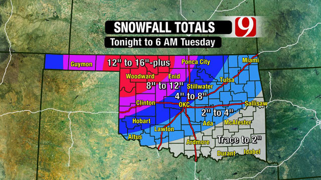
We have a News9 graphic below that shows the current thinking on how many inches of snow could end up falling across the state. Keep in mind- this snow will be preceeded with rain- so these next few days are shaping up as yet another shot of moisture that could result in another assault on ending the worst of the drought conditions across Oklahoma.
Updated at 4:15 AM- the graphic below is updated to show well over a foot of snow is possible in northwest Oklahoma. Rainfall from this system thus far is already piling up- Weatherford has recorded 1.38 inches of rain- Cherokee with 1.25, Hobart with 1.22 and Seiling with 1.20 inches of rain. Click here for a 24 hour rolling update of rainfall for the state from the Oklahoma Mesonet
WebReadyTM Powered by WireReady® NSI
Top Agricultural News
More Headlines...


