


Agricultural News
Mini El Nino Event the Reason for Recent Storms- With Another Tracking Our Way for Next Weekend
Sun, 03 Mar 2013 07:07:25 CST
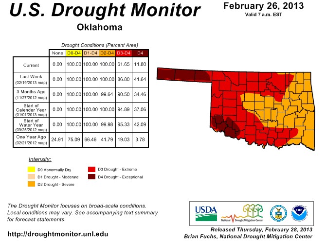 The rain and snow that came across the southern Great Plains- including across Oklahoma- has "really moved the needle" when it comes to reducing the severity of the drought across the region- so says Meterologist Bryce Anderson who forecasts weather with a eye on how it impacts agriculture for DTN. Anderson says the moisture fully reduced drought across the region by one full category- very significant at this time of year. The systems- pushed along by the subtropical jet stream- have given two significant rain and snow producing systems in as many weeks to water the parched soils of much of Oklahoma. Farm Director Ron Hays talked with Anderson at the 2013 Commodity Classic and you can hear their full conversation by clicking on the LISTEN BAR below.
He says the weather models suggest another Pacific based storm seems to be lining up to come right at Oklahoma this coming Friday and Saturday- he calls it "obviously very well timed" in keeping the recharging of soil moisture going for the region. The reason for this line of storms that have been rolling across the southern US seems to come from a bump up in barometric pressure along the equator in the Pacific- Anderson calls it a "mini El Nino."
For the US Corn Belt- Anderson says the general consensus of thinking is that we won't have a second year of drought in the US Corn Belt. However, Anderson contends that history does not necessarily agree with that thinking. He sees the Eastern Corn Belt with a good chance of jumping back to more normal yields in 2013- but has concerns about the Western Corn Belt having more heat and dry weather ahead in the coming growing season- dragging the national yield downward.
Hays and Anderson also talked about long term weather models and the chances for an El Nino in 2013.
WebReadyTM Powered by WireReady® NSI
Top Agricultural News
More Headlines...


