


Agricultural News
Heaviest Rainfall Totals Clustered in Center of Oklahoma- a Map as of Monday Morning, July 15, 201
Mon, 15 Jul 2013 06:39:33 CDT
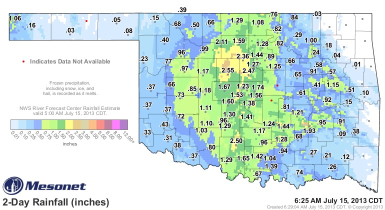 Precipitation has piled up in mostly the middle third of the state of Oklahoma to this point with more smaller amounts of rain found in the east and in the west to this point. Rainfall remains in the forecast for at least Monday and Tuesday for a lot of Oklahoma.
Alan Crone in Tulsa writes this morning on his regular blog on the News on 6 website "This somewhat unusual weather pattern that brought us a pleasant cool down yesterday with scattered storms across eastern Ok will remain through at least Tuesday, and possibly Wednesday, before the heat and humidity return for the second half of the week. The large upper level low is now located west to southwest of the immediate area. We'll continue to have a shot at periodic showers and storms circulating around the main upper level low for the next 36 to 48 hours before the low weakens more as it slides westward.
"The area that received the most rainfall yesterday was central and western OK where 1 to 2 inches of rain occurred as temps remained in the upper 60s and lower70s for afternoon highs."
Largest single rainfall location to this point from this system belongs to Kingfisher (based on Mesonet data) with 2.55 inches of rainfall on July 14th!?!!?! AND- lots of locations with much cooler than normal temps and rainfall of more than an inch of rainfall.
The map above shows a snapshot as of Monday morning of the rainfall to date.
WebReadyTM Powered by WireReady® NSI
Top Agricultural News
More Headlines...


