


Agricultural News
Gary McManus Says Recent Storm System has now Become 'Legendary'
Thu, 18 Jul 2013 14:28:26 CDT
The upper-level storm system that visited Oklahoma with ample rains from the east has now become legendary, says Associate State Climatologist Gary McManus. He says meteorologists are saying they've never seen such a storm develop and move from the east in summer, at least a storm of non-tropical origin. (Radio Oklahoma Network Farm Director Ron Hays spoke with McManus about the event and you can hear their conversation by clicking on the LISTEN BAR at the bottom of this story.)
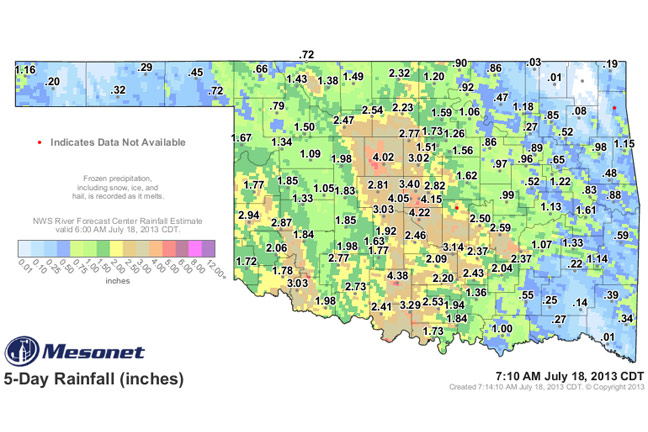
Not all parts of the state shared in the bountiful rains. Vinita received no rain. Less than half an inch fell in the Panhandle, northeastern and southeastern Oklahoma. When the places where it did rain are combined with the places where it didn't rain, it adds up to only the 38th wettest July on record with a statewide average of 1.67 inches. That's only 0.8 inches above normal, McManus says.
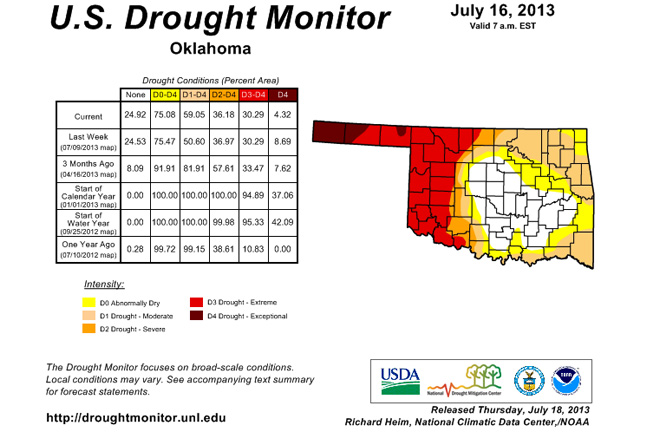
Given that fact, McManus says this week's drought map contains a few surprises. There is still a "drought hole" across central and eastern Oklahoma. The amount of the state at least in D1-Moderate drought went up from 51 percent to 59 percent. McManus said that surprising turn of events is due to the fact it rained most where they needed it the least.
The drought eased slightly in southwestern Oklahoma where they dropped from D4-Exceptional drought to D3-Extreme drought. That's the first time since August 7, 2012 that D4 has disappeared in the southwest.
On the opposite side of the state, however, McManus says drought actually increased in both southeastern and northeastern Oklahoma. Those areas have missed out on good rains since mid-June. The U.S. Seasonal Drought Outlook through the end of October now shows drought developing or persisting in those parts of the state where it is non-existent now, McManus said.
WebReadyTM Powered by WireReady® NSI
Top Agricultural News
More Headlines...


