


Agricultural News
Mapping Team and Flood Control Dams Aiding in Firefights
Tue, 06 May 2014 14:12:33 CDT
Emergency management directors and the National Guard are utilizing geographic information systems (GIS) provided by the Oklahoma Conservation Commission (OCC) and flood control dams maintained by local conservation districts to fight fires and save lives-most recently during the Logan County blaze.
Working from the State Incident Command Post on Seward Road in Guthrie, OCC's Office of Geographic Information is providing mapping support to teams working to contain the fire in Logan County as well as to the State Emergency Operations Center managed by the Oklahoma Department of Emergency Management (OEM). Maps are being used by firefighting and emergency rescue crews to safely access the area at risk and identify means of keeping the fire contained.
Similar mapping services were provided to OEM and the National Guard in the aftermath of the 2013 Moore tornado.
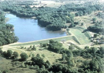
Overhead, three National Guard Black Hawk helicopters equipped with dip buckets to provide aerial fire support are accessing water captured by some of the 39 flood control dams maintained by Logan County Conservation District.
"We're pleased to know the Guard is able to utilize the flood water impoundment coordinates to help in the firefight and are glad for the opportunity to make this contribution to wildfire control in Oklahoma," said Robert Toole, OCC assistant director.
Coordinates to Oklahoma's 2,107 flood control dams maintained by local conservation districts across the state were first used by the National Guard to fight the large wildfire near Choctaw in 2013. Access to the coordinate database allows National Guard helicopters to identify optimal water supplies en route to an incident and arrive with a full dip bucket, rather than having to find sources of water once they arrive at a fire.
Oklahoma's Watershed Dam Program represents a $2 billion public infrastructure that provides an estimated $85 million in benefits to Oklahoma annually. In addition to firefighting, the dams help protect homes and crops from flooding, and in some cases, provide municipal water supplies.
WebReadyTM Powered by WireReady® NSI
Top Agricultural News
More Headlines...


