


Agricultural News
Weekend Rainfall Blankets the State- The Latest Maps
Mon, 09 Jun 2014 05:47:28 CDT
 Rainfall has piled up across Oklahoma since the middle of last week, especially starting Thursday evening, with waves of storms washing across Oklahoma Friday, Saturday and Sunday evenings. The latest wave of rainfall has concentrated on the southern half of the state and continues on Monday morning.
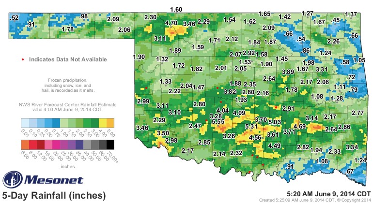
We have two graphics for you- the first one is above and shows rainfall since Wednesday morning of last week through 5:00 AM on this Monday morning. Only one Oklahoma Mesonet station- Vinita- has less than a half inch of rainfall for the period, with the heaviest amounts showing in south central Oklahoma- Acme, Bowlegs, Ada and Pauls Valley all showing more than five inches of rainfall over the last five days.
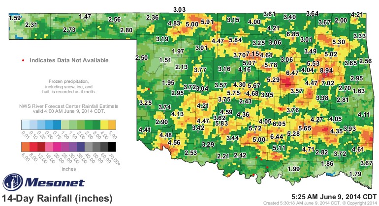
The graphic below is for the past two weeks- and shows how wet June has turned out to be thus far. There are literally no Mesonet stations with less than an inch of rainfall for this period- and Porter in eastern Oklahoma has clocked 8.94 inches of rain in this two week period.
The results of these recurring rain storms is improvement in top soil moisture supplies, ponds filling and even some of our lake levels coming up from their late spring lows. These rains came too late for much benefit for the 2014 winter canola and winter wheat crops- and are now disrupting wheat and canola harvest and likely degrading the quality of both crops as we wait for dryer weather to allow the combines back into the fields.
WebReadyTM Powered by WireReady® NSI
Top Agricultural News
More Headlines...


