

To view the latest Oklahoma drought map, CLICK HERE.
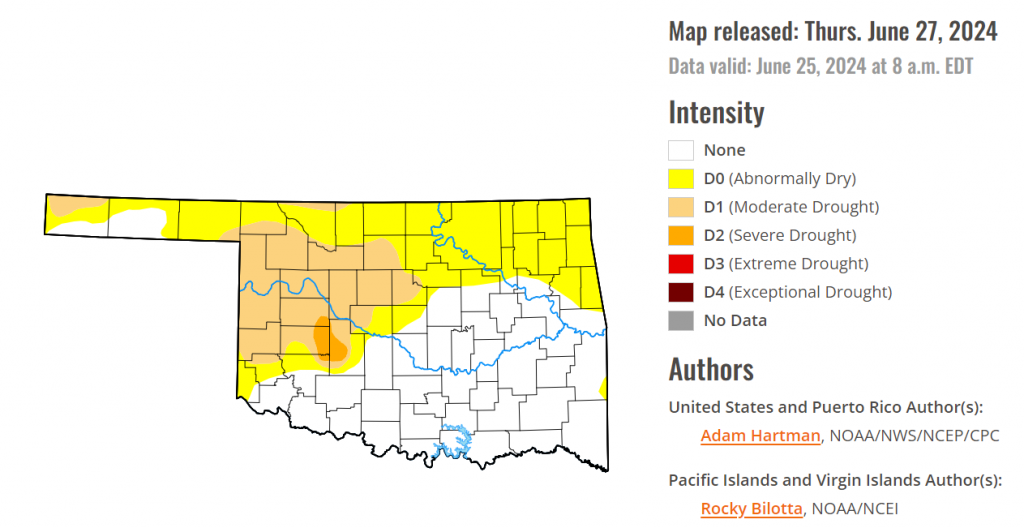
According to the latest Oklahoma drought monitor report, exceptional drought and extreme drought remain at zero percent, unchanged from the start of the calendar year.
Severe drought or worse is now at 1.03 percent, slightly down from last week’s 1.20 percent.
Moderate drought or worse is now at 20.48 percent, slightly down from last week’s 20.82 percent.
Abnormally dry or worse conditions are now at 52.12 percent, up from last week’s 37.17 percent.
According to the 6-to-10-day precipitation outlook map, the majority of the state aside from the panhandle and the southeast corner is near normal chances of precipitation through July 6th. The panhandle is leaning above a 33 to 40% chance of precipitation through July 6th, while the extreme southeast corner is leaning below a 40 to 50 percent chance of precipitation through that July 6th date.
To view the United States Drought Map, CLICK HERE.
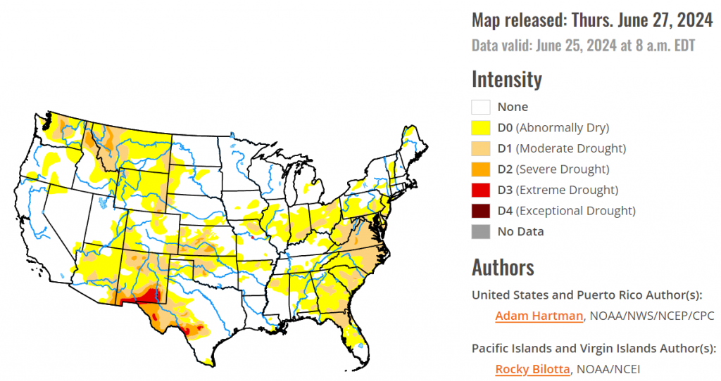
According to the latest U.S. Drought Monitor, Much of the eastern contiguous U.S. (CONUS), south of the Great Lakes, received little to no rainfall, and this is on top of several weeks of below normal rainfall leading up to last week. In addition, temperatures have remained hot for many locations. This combination of antecedent dryness, much below normal rainfall, and hot temperatures has resulted in rapidly deteriorating conditions, particularly across the Ohio Valley, Mid-Atlantic, and Southeast, with large increases in abnormally dry (D0) and moderate drought (D1) conditions. Conversely, southern Texas, the Four Corners region, and the Upper Midwest and Northern Plains experienced several rounds of heavy rainfall. Some locations across southern Texas (associated with Tropical Storm Alberto) and the north-central CONUS received well in excess of 5 inches of rainfall that led to flash and river flooding, as well as improvements to drought conditions. Some localized flooding also occurred in portions of the Four Corners region, associated with a surge of tropical moisture from the remnants of Tropical Storm Alberto that came ashore in northern Mexico late last week. Across much of the western CONUS, conditions are starting to dry out a bit, particularly in the Pacific Northwest and northern Rockies. In Alaska, moderate drought was introduced in the eastern interior Mainland, where warm and dry weather continues, elevating fire concerns. In Hawaii, trade winds are lacking moisture resulting in below normal rainfall across the islands and the widespread expansion of abnormal dryness. Puerto Rico continues to remain drought-free.
In the Southern Plains, the passage of Tropical Storm Alberto in northern Mexico resulted in a large influx of moisture into southern Texas, with widespread 5 inch rainfall totals (locally upwards of 8 inches for some locations). This heavy rainfall caused localized flash flooding and resulted in large improvements to soil moisture. However, leading up to last week, southern Texas was experiencing abnormally dry and moderate drought conditions, so despite some large improvements (2-category improvements in some cases), some parts of southern Texas remain abnormally dry given the rainfall deficits leading up to Alberto’s landfall. Heavy rainfall also fell across portions of the Oklahoma Panhandle, with several locations receiving in excess of 5 inches of rain, warranting some targeted 2-category improvements to the drought depiction there as well. Elsewhere in the Southern region, conditions are rapidly deteriorating, as rainfall has been lacking entirely over the past few weeks for many locations. Persistent heat has exacerbated the ongoing dryness, leading to degradations across parts of the Tennessee and Lower Mississippi Valleys, western Texas, and northern Oklahoma. Following a very wet May, the last few weeks have been very dry across eastern Texas and this area will need to be monitored in the coming weeks if warmer than normal temperatures persist.
The High Plains region experienced a mixture of both deteriorating and improving drought conditions last week, which has predominantly been the case over at least the last month. High pressure over the eastern U.S. and an active storm track across the northern tier of the lower 48 states have been able to funnel moisture northward over the past few weeks, but precipitation has been hit-and-miss from week to week. However, last week was a little different from prior weeks, as some of the moisture from Tropical Storm Alberto was funneled northward into the Four Corners region and then into the Central and Northern Plains. Southeastern South Dakota received in excess of 5 inch rainfall surpluses for the week leading to flooding along the Missouri River and some of its tributaries. Heavy rain also fell across parts of southeastern Colorado and southwestern Kansas last week, associated with the surge of moisture from Alberto, leading to some targeted improvements to the drought depiction in those areas as well. Elsewhere in the High Plains region, targeted degradations are warranted due to antecedent dryness, below normal weekly precipitation, and predominantly above normal temperatures (with the exception of northern Montana and the Dakotas).
In the West, a surge of moisture from Tropical Storm Alberto led to widespread, localized heavy rainfall across portions of the Four Corners region, leading to localized flash flooding and targeted drought improvements across Arizona, New Mexico, and southeastern Colorado. Conversely, targeted degradations are warranted across parts of the interior Pacific Northwest and northern Rockies, where warm and dry weather prevailed. Elsewhere in the West, conditions are largely drying out, but the influx of tropical moisture from Alberto has helped to stall the progression of the dryness a bit for many locations.
Looking ahead, during the next five days (June 27 – July 1), a couple of storm systems and trailing frontal boundaries are forecast to bring periods of rainfall to portions of the eastern U.S. These storm systems are likely to usher in some cooler than normal air behind them, particularly across the northern tier of the lower 48 states. Temperatures are expected to remain predominantly warmer than normal across the southern tier of the U.S., with excessive heat also possible across the Gulf Coast states.
The Climate Prediction Center’s 6-10 day outlook (valid July 2 – 6), favors enhanced chances of above average temperatures across the southern two-thirds of the lower 48 states and near to below normal chances across the northern tier states. Near to below normal temperatures are also favored in the Desert Southwest, due to the increased potential for above normal precipitation. Below normal precipitation is favored across parts of California and Nevada, and across the southeastern U.S. Increased above normal precipitation chances are favored elsewhere across the lower 48 states, with the highest chances across portions of the Southwest and Midwest.
To view the 6-10 Day Precipitation Outlook Map, click here.
To view the 6-10 Day Temperature Outlook Map, click here.
To view the Monthly Drought Outlook Map, click here.


