

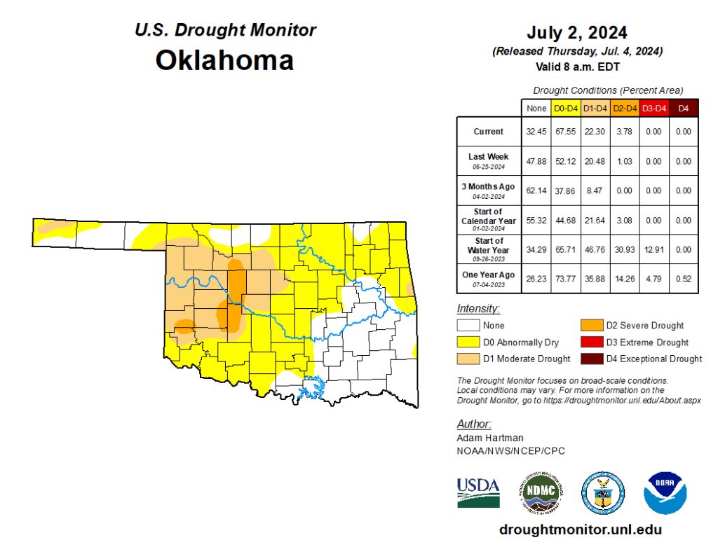
According to the latest Drought Monitor for Oklahoma released July fourth, while Oklahoma remains free of extreme or exceptional drought as we begin July- recent weeks have seen a rapid spread of Abnormally Dry or worse conditions in all but southeastern Oklahoma.
The coverage area of just Abnormally Dry has grown by forty percent in a single week- and now covers all of the western half of the state and much of northeastern Oklahoma as well.
Severe drought has increased to 3.78% of the state- mainly covering some of Major County, all of Blaine County as well as parts of Beckham, Caddo, Custer, Greer and Washita counties. Last week- 1.03% of the state was in severe drought.
Moderate drought or worse rose 2 percentage points- from 20.48% to 22.3% from last week to this week. North Central into West Central parts of the state are the driest and where we are finding Moderate drought conditions.
Abnormally dry or worse ratings have jumped from 53.12% of the state to 67.12% of Oklahoma colored yellow in the graphic above. While that is still not as bad as early July 2023- it is getting close as the Abnormally dry or worse number a year ago was 73.77%.
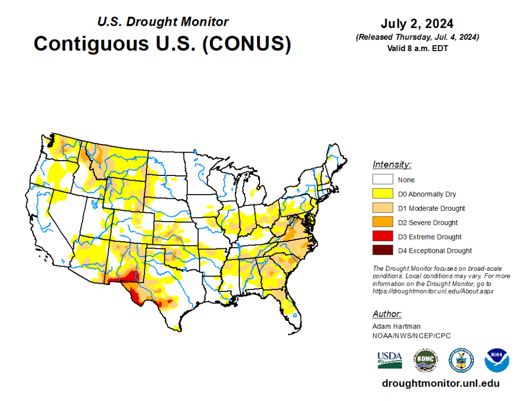
Nationally, Drought Monitor stats show drought levels up across the US- with southern eastern seaboard states showing a lot moderate to severe drought. Moderate drought is up to 18.67% from 16.13% a week ago- and the Abnormally dry or worse number is nearing the fifty percent market across the lower 48 states at 47.26%.
Kansas Drought Monitor status has improved compared to a week ago- with moderate drought or worse improving by seven percentage points to 21.29% (versus 28.16% last week) and the Abnormally dry number falling six points- from 60.8% to 54.6% this week.
Texas Drought Monitor saw slight expansion on the overall numbers- Severe drought up to 12.86% versus 11.95% last week- Moderate drought essentially flat at 25.6 versus 25.06% week to week and Abnormally dry or worse now at 46% this week versus 38% last week.
The High Plains region experienced a mixture of both deteriorating and improving drought conditions this week, which has also predominantly been the case over at least the last month. A couple of troughs of low pressure moved across the western and central U.S. this week, helping to tap into some moisture from the Pacific Ocean and draw it into the region. This resulted in heavy rainfall across parts of the Four Corners and extending eastward into the Central and Eastern Plains. Parts of Kansas and eastern Nebraska received well in excess of 3 inches of rainfall. Unfortunately, several locations across the western High Plains region were not so lucky and received below normal weekly rainfall. Temperatures were also unseasonably warm, running anywhere from 4°F to 8°F above average for the week in many areas, helping to exacerbate worsening conditions.
Looking ahead-
During the next five days (July 3 – July 7), High pressure is likely to build over the western U.S., leading to hot, potentially record-breaking temperatures and below normal precipitation. Farther eastward, East of the Rockies, temperatures are forecast to become more seasonal for the most part. In addition, parts of the Middle and Upper Mississippi Valley are likely to experience a couple of rounds of heavy rainfall. Rainfall in excess of 1 inch is favored across parts of the Ohio Valley, Mid-Atlantic, and Southeast.
The Climate Prediction Center’s 6-10 day outlook (valid July 8 – 12), favors enhanced chances of above average, potentially record-breaking, temperatures across parts of the Intermountain West, with above normal temperatures changes extending into the Western Plains, along the Gulf Coast, and into the eastern U.S. Below normal temperatures are favored in the interior central U.S. Near and below normal precipitation is likeliest across the western and north-central U.S., with above normal precipitation favored elsewhere. Eyes will be on the tropics over the next 6 to 10 days, with enhanced chances for above normal precipitation across southern Texas and the western Gulf Coast. Near to below normal temperatures and above normal precipitation is favored in Alaska and Hawaii.


