

Thu, 22 Sep 2022 09:41:32 CDT
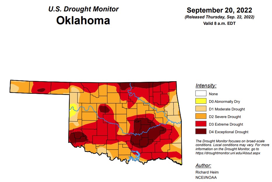
According to state climatologist, Gary McManus, there are new areas of exceptional drought across a significant portion of the area east of Oklahoma City, in addition to new areas across northeast Oklahoma and along the Kansas border and Blaine/Kingfisher counties. As for D3(extreme drought or worse) and D2 (severe drought or worse) conditions, McManus said Oklahoma is seeing levels that have not been present since early 2013, and conditions are not looking to improve in the next couple of weeks.
In Oklahoma, exceptional drought is at 13.6 percent, jumping 10 percentage points since last week. (Last week was 3 percent)
Extreme drought or worse is up from last week’s 48.8 percent and is now at 53.9 percent.
Severe drought or worse has reached 89.2 percent, up from last week’s 85.4 percent.
Moderate drought has increased to 98.9 percent, up from last week’s 96.5 percent.
Abnormally dry or worse conditions are unchanged from last week at 99.9 percent.
According to the 6-10-day precipitation outlook map for Oklahoma, the state shows a below-normal chance of precipitation through October 1, with the eastern side of the state showing the lowest percent chance.
To view the Oklahoma Drought map, click here.
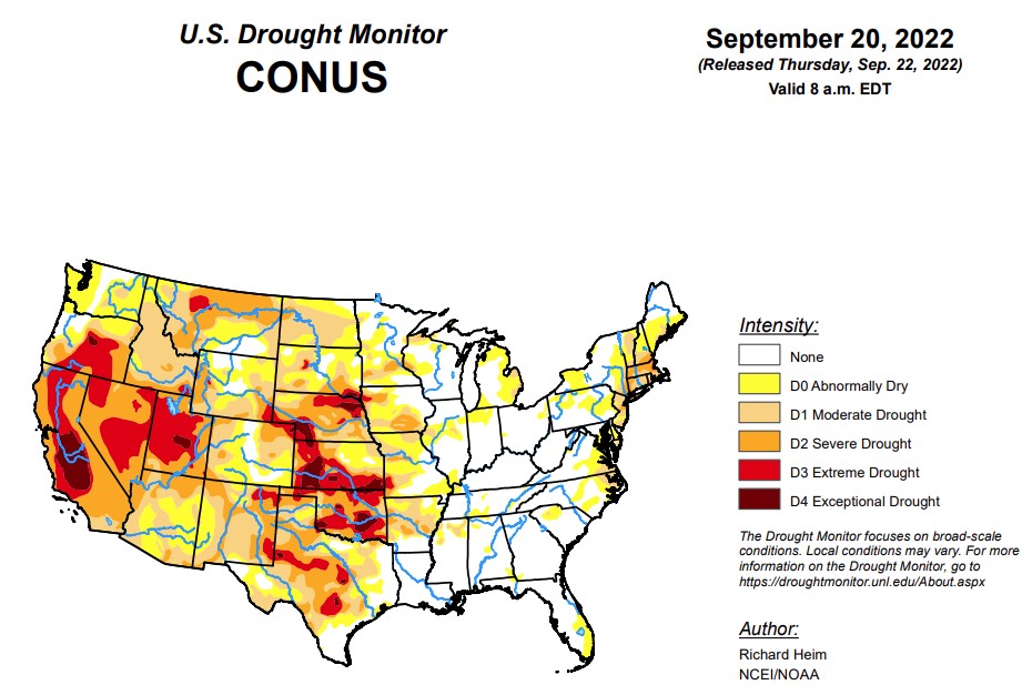
According to this week’s U.S. Drought Monitor Report, an upper-level ridge dominated the central contiguous U.S. (CONUS) during this U.S. Drought Monitor (USDM) week (September 14-20). It was bracketed by an upper-level trough which moved out of the Northeast early in the week, and a Pacific upper-level trough that moved into the West as the week progressed. Pacific weather systems moved across the northern states between the troughs. This pattern resulted in above-normal precipitation across much of the West and parts of the Northeast. Fronts associated with the Pacific systems triggered showers and thunderstorms across parts of the central and northern Plains to Mid and Upper Mississippi Valley. For the rest of the CONUS, a large dry air mass covered much of the southern Plains and East throughout the week. Rain occurred along a stationary front draped across Florida that was associated with the southern edge of the air mass, but for much of the South, Southeast, Mid-Atlantic, and Midwest regions it was a dry week. Temperatures averaged warmer than normal across the Plains to Great Lakes, and cooler than normal across much of the West, Southeast, and northern New England. A tropical system brought heavy rain to Puerto Rico and the Virgin Islands. Drought or abnormal dryness expanded or intensified across northern parts of the West, from the central and northern Plains to the Mid- and Upper Mississippi Valley, and over parts of the Mid-Atlantic coast. Drought or abnormal dryness contracted where it rained, especially in parts of Florida, New Mexico, and the Northeast, in a swath from Iowa to Illinois, and across Puerto Rico.
In the Southern Plains, a few areas of the Gulf Coast and western Texas received up to half an inch of rain this week, but the South region was, for the most part, dry with no rain falling. Moderate and severe drought contracted slightly in a couple spots in southern Texas, and abnormal dryness and moderate drought expanded in a couple other areas of the Lone Star State and abnormal dryness expanded in Tennessee. But the biggest changes occurred in Oklahoma and Arkansas. D1-D4 expanded in Oklahoma and D0-D2 expanded in Arkansas. Soils continue to dry and groundwater and stream levels are low. According to U.S. Department of Agriculture (USDA) statistics, 82% of Oklahoma’s topsoil moisture is short to very short of moisture (dry to very dry). The only drier years in mid-September in data going back to 2010 were 2011 and 2012, which were very bad drought years. All states in the region except Louisiana and Mississippi had half or more of the topsoil moisture short or very short of moisture. Almost 70% of the pasture and rangeland in Oklahoma was in poor to very poor condition. Ponds in Oklahoma are drying up and 63% of the cotton crop is in poor to very poor condition.
In the High Plains, region had rain while other parts were dry. Up to two inches fell locally in parts of several states. Especially dry areas occurred in parts of the Dakotas, Montana, Kansas, and Colorado. The lack of rain was accompanied by unusually hot temperatures regionwide, which increased evapotranspiration and accelerated the drying of soils. The drying soils and dry ponds and waterholes led to extensive expansion of D0-D2 in North Dakota and Montana, and D0-D4 in South Dakota and Kansas. Groundwater levels are low with wells in Wichita, Kansas, going dry. According to media reports, a water emergency developed in Caney, a town in southeast Kansas, when water stopped flowing over the Little Caney River’s dam; there are 6 weeks of water supply left. D1 and D2 expanded in parts of Colorado, and D3 expanded in southeast Wyoming while other parts of the state saw contraction of D0 and D1. Nebraska also had some contraction of D2, but expansion of D1-D3 in other parts of the state. According to USDA statistics, all states in the region had half or more of the topsoil moisture short or very short of moisture. In Nebraska and Kansas, three-fourths of the pasture and rangeland was in poor to very poor condition, while the value was 50% for Colorado, 55% for South Dakota, and 58% for Montana.
In the West, pacific weather systems dropped locally 2 or more inches of rain across parts of central and northern California, and over local areas of the Great Basin and southern New Mexico. Half an inch or more of precipitation occurred over large parts of the interior West. Other parts, especially much of Washington, Oregon, northern Idaho to northwestern Montana, and southern California to parts of New Mexico, were dry this week. Groundwater continues low and many reservoirs were still very low to near record low. The water levels in most reservoirs in New Mexico are well below average. The August 2022 total combined end-of-month storage of 12 large reservoirs in the state ranked among the three smallest August totals since 1990. The precipitation that fell this week did little to make up deficits that have built up over the last 5 years, so little improvement was made on this week’s map over the areas that received precipitation. One exception was southern New Mexico and adjacent Arizona, where D1-D3 contracted in the wetter areas this week that have also benefited from a wet monsoon season. In northern parts of the West region, D0 was added to western Washington and northwest Oregon where streams were low, very warm temperatures increased evapotranspiration and continued to dry soils, and precipitation was below normal for the last 3 months. D1 expanded in northern Idaho where several indicators reflected the dry conditions of the last 3 months, and several dozen large wildfires continued to blaze. According to USDA statistics, all of the states in the region except California, Nevada, and Arizona had half or more of their topsoil moisture short or very short of moisture.
To view the contiguous U.S. Drought map, click here.
Looking ahead, a strong upper-level low-pressure system will move across the northern half of the CONUS during September 22-27 while high pressure generally dominates the southern half of the country. By the end of the period, the upper-level circulation pattern will consist of a ridge over the West and a trough over the East. This scenario will result in above-normal temperatures in the West and South with below-normal temperatures in the Northeast. Half an inch or more of precipitation, locally up to 2 inches, is forecast to fall from the Four Corners states to the northern Rockies and eastward to the central and northern Plains, as well as across parts of the Great Lakes, much of the Northeast, and over southern Florida. Half an inch or less is expected over Oregon, the Mid to Upper Mississippi Valley, the Tennessee Valley to Appalachian chain, and Mid-Atlantic Coast. Little to no precipitation is predicted for Washington, California, and Nevada in the West, across the southern Plains to Southeast, and over parts of the Midwest. For September 28-October 5, the western ridge and eastern trough pattern is expected to persist. Odds favor warmer-than-normal temperatures across the West to Mississippi Valley and the Alaskan panhandle, with cooler-than-normal temperatures from the Northeast to southern Appalachians and over southwest Alaska. The circulation pattern will likely result in below-normal precipitation from the Pacific Northwest to Northeast, across the Great Plains to Mississippi Valley, and over the Ohio Valley as well as western Alaska. Odds favor above-normal precipitation over the coastal Southeast, the eastern half of Alaska, and a small area in the Four Corners states.
To view the 6-10 Day Precipitation Outlook Map, click here.
To view the 6-10 Day Temperature Outlook Map, click here.
To view the Monthly Drought Outlook Map, click here.


