Oklahoma National Stockyards
Mon Aug 22, 2022
AUCTION
This Week 7,500
Last Reported &nbs…


Aug 23
Oklahoma National Stockyards
Mon Aug 22, 2022
AUCTION
This Week 7,500
Last Reported &nbs…
Aug 23
Oklahoma National Stockyards
Mon Aug 22, 2022
AUCTION
This Week 7,500
Last Reported &nbs…
Aug 23
Joplin Regional Stockyards
Mon Aug 22, 2022
AUCTION
This Week 4,310
Last Reported  …
Aug 23
Joplin Regional Stockyards
Mon Aug 22, 2022
AUCTION
This Week 4,310
Last Reported  …
Aug 22
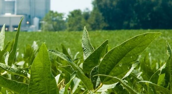
Corn and soybean good-to-excellent condition ratings both fell slightly again last week, USDA reported in its weekly Crop Progress report released Monday, Aug. 22.
Not any extreme changes in crop condition ratings in this week’s US…
Aug 22
The U.S. Department of Agriculture and the Oklahoma Department of Agriculture are now putting the Daily Cash Grain Report into a PDF format – we are saving that PDF and archiving them for today’s specific report. To see today’s update, click on the PDF report link at the bottom of this story.
In addition to the PDF of the daily report, you can also listen to the Cash Grain Report by calling 405-621-5533. Push 2 for the grain report.
Aug 22
The USDA’s National Agricultural Statistics Service (NASS) is in the process of surveying growers on key farm issues. The National Corn Growers Association (NCGA) encourages growers to complete the following upcoming surveys:
…
Aug 22
Today, Gov. Mike Parson called for a special legislative session to extend key agricultural tax credits. The following collaborative statement is provided on behalf of the Missouri Agribusiness Association, Missouri Cattlemen’s Associ…
Aug 22

Listen to today’s report with Justin Lewis, by clicking or tapping on the LISTEN bar
Aug 22
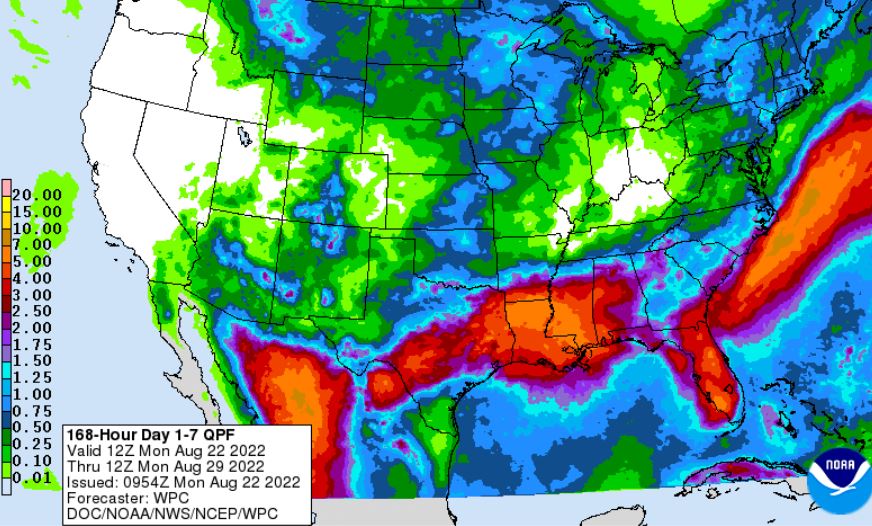
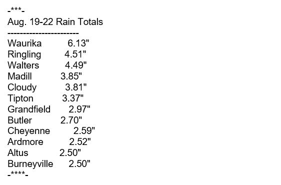
Thankfully some parts of the state saw some widespread rain events over the past few days. According to State Climatologist Gary McManus, the radar estimated rainfall shows a large area of 4-6 inches of rain down across southern Oklahoma, with some totals in very localized areas probably approaching 8+ inches. So a large amount of rain over a short time frame that obviously led to some pretty serious flooding concerns.
6.18 inches (and counting) of rain at Waurika is more than they had seen in the previous 87 days combined, dating back to May 25!
Another benefit of all the clouds and rainfall is the much milder (if not much more humid) weather, Mcmanus says is that we even saw some record low maximum temperatures yesterday across western Oklahoma where some sites failed to eclipse the 60s.
McManus says we will bust up into the 90s a couple of times this week across parts of Oklahoma, it does appear that we have transitioned from “hot most of the time but broken up by a day here or there with some cooler weather” to just the opposite. At least for the time being. He says we should see an extended period of seasonable-to-cooler than normal weather, with maybe a few hot days intermixed, at least for another week or two. The heat will be concentrated up in northern Oklahoma where the rain missed, but don’t count out some high heat index values to the south. Friday is a good example of what to expect.
McManus says he believes we have switched for September. But, that long-term average high temperature graph starts a pretty sharp downward trend as we get into September. And notice the mostly steady above normal weather we’ve seen with that persistent heat dome over the area since June 11.
McManus says the 7 day rainfall forecast does show big rain chances coming next weekend, and that it does look like we are going to bookend our hot climatological summer with mild rainy periods both at the start of June and then to finish out this month.


![]()
