Agricultural News
Severe Drought Rears Its Head in Oklahoma for First Time Since October 2018 - But Will It Last?
Thu, 08 Aug 2019 10:51:24 CDT
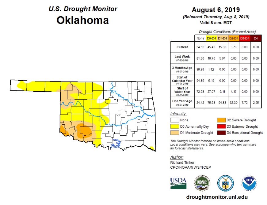
 Severe drought has made an appearance in the state for the first time since October 2018, according to the latest U.S. Drought Monitor report.
"Playing through a nearly ideal 'flash drought' scenario," Oklahoma State Climatologist Gary McManus in this week's Mesonet Ticker newsletter, "the abrupt end of beneficial rains during June and then through July into August, coupled with periods of intense summer heat, and adding in an overgrowth of vegetation from the heavy rains of spring (have placed) a ton of pressure on our available moisture supply."
This has led to a rapid decline in soil moisture, again following the script of a flash drought scenario. Deficits are currently scattered across the western half of Oklahoma on the Oklahoma and continue to grow. Today's report pegs 45% of the state in "Abnormally Dry" conditions; 15% in "Moderate Drought"; and just under 4% in "Severe Drought" conditions. However, McManus also reports that these areas hit hardest by drought conditions, are also getting rain presently - not a lot - but with potential for heavier amounts. There will be additional rain chances through early next week, mainly in the northern part of the state.
The Climate Prediction Center is currently predicting increased odds for above normal temps and below normal precipitation into next week which will continue to fuel any flash drought conditions if that happens. However, there is the potential that model could change with the latest reports showing the potential for possible rain chances into next week as well if the current heat dome breaks down.
Click here for a closer look at this week's Drought Monitor Map or to review McManus' full remarks, click here.
WebReadyTM Powered by WireReady® NSI
Top Agricultural News
More Headlines...


