

Agricultural News
Latest U.S. Drought Monitor Map Shows Extreme Drought Continues To Creep Ever Closer To Oklahoma
Thu, 14 May 2020 17:16:02 CDT
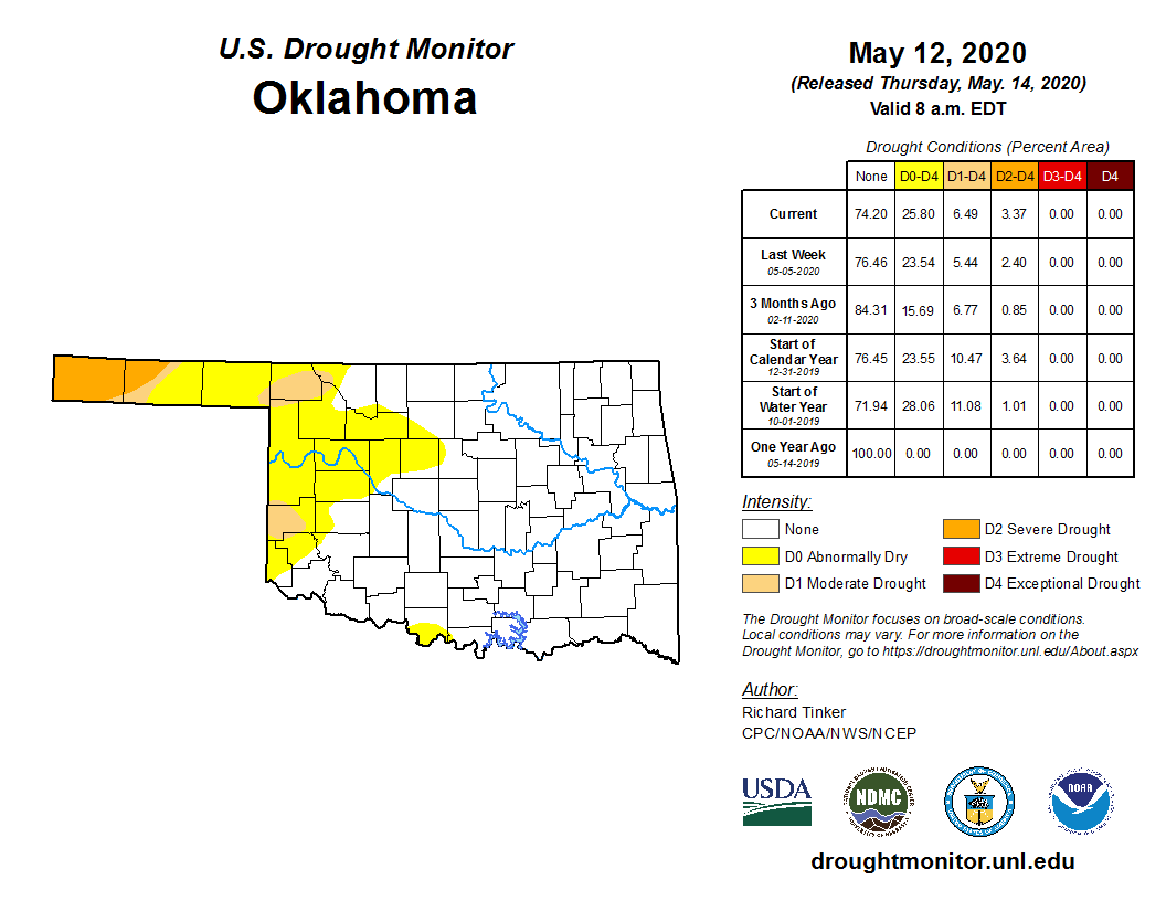
 Moving at the pace of a giant sloth, areas of extreme drought (D3) are slowly expanding and moving ever closer to Oklahoma. Meanwhile, for the High Plains region, drought is intensifying across the southern tier from southern Colorado through western Kansas.
Severe drought (D2) covers much of southern Colorado and southwestern Kansas. This region has recorded less than one inch of precipitation during the past 3 months.
Currently almost 26 percent of Oklahoma is swathed in shades of yellow and light brown (D0-D4), which is about a 2.5 percent increase from last week and at the start of the calendar year. Severe Drought (D2) now covers all of Cimarron County and about one-third of Texas County in the Oklahoma Panhandle.
According to the U.S. Drought Monitor's definition of severe drought, dryland crops are severely reduced and pasture growth is stunted and cattle are stressed. If the D3 Extreme Drought expands, we could see pastures go dormant and the danger of wildfires goes up.
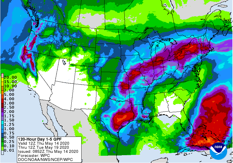
The regional precipitation forecast looks promising during the next 5 days as a broad swath of heavy rain is expected from south Texas northeastward across Missouri. Central and south Texas is expecting 3 to 5 inches of rain. Smaller areas in northeast Oklahoma and southeast Kansas expected to get 3 to 4 inches.
However, the driest areas in western and northwestern Oklahoma will be mostly bypassed.
According to the NOAA forecast map, there will be chances of rain and storms over the next few days, but after that we dry out for the weekend and the temperatures shoot back up into the 70s and
80s.
To view the 5-day rain forecast, click here.
To view the Oklahoma Drought Monitor map, click here.
To view the U.S. Drought Monitor map, click here.
The U.S. Drought Monitor Map is developed through a partnership between the National Drought Mitigation Center at the University of Nebraska-Lincoln, the United States Department of Agriculture, and the National Oceanic and Atmospheric Administration.
WebReadyTM Powered by WireReady® NSI
Top Agricultural News
More Headlines...


