

Agricultural News
Latest U.S. Drought Monitor Map Shows Drought Conditions Continue To Expand Across Oklahoma
Thu, 21 May 2020 15:54:53 CDT
 Unfortunate as it may seem, parts of the upper Midwest are too wet, and people are suffering from flooding. That is not the case here in the Plains this week.
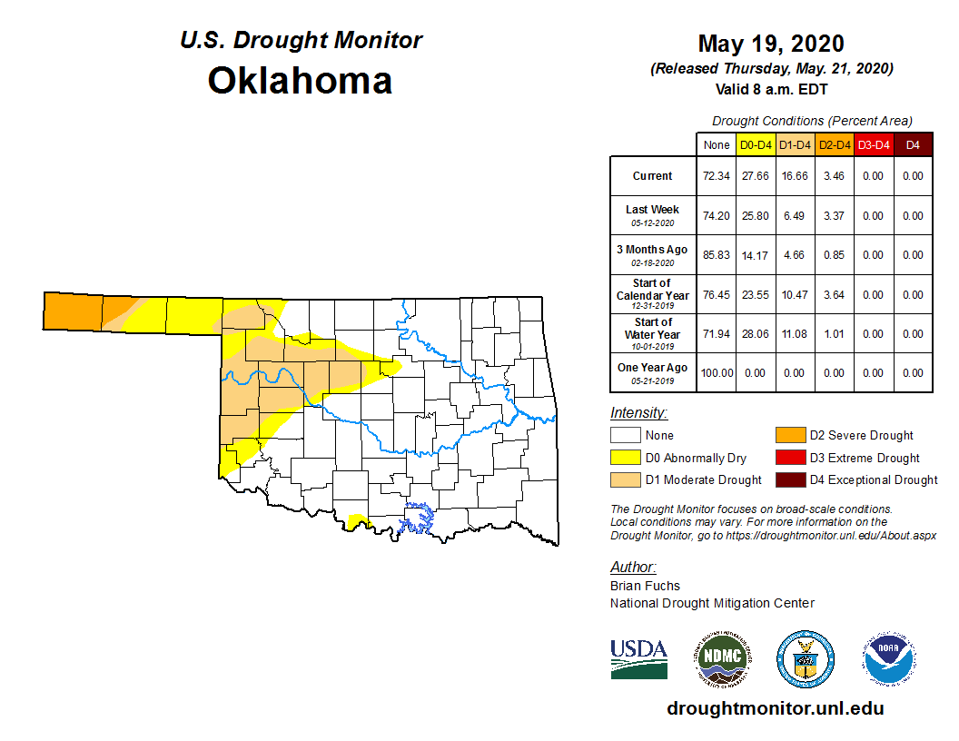
Drought conditions continue to creep across Oklahoma as 16.6 percent of the state is now listed in the moderate drought or worse category. That is more than a 10 percent jump from last week (6.49 percent). Almost 28 percent of the state is in the yellow shade of abnormally dry or worse (D0-D4) which is several points worse than last week.
The area of most concern continues to be the Panhandle where all of Cimarron and about one-third of Texas Counties are in severe drought.
According to the folks at the Oklahoma Mesonet, west central Oklahoma has suffered through its 7th driest last 60 days on record, dating back to at least 1921, and much of western Oklahoma hasn't fared much better.
The dry areas now reach as far east as Logan and Payne Counties.
According to the U.S. Drought Monitor's definition of severe drought, dryland crops are severely reduced and pasture growth is stunted and cattle are stressed. If the D3 Extreme Drought expands, we could see pastures go dormant and the danger of wildfires goes up.
Nationally, abnormally dry conditions expanded this past week through central and southeast Nebraska and portions of northeast Kansas. These areas could see drought development if it doesn't rain soon.
In addition to the expanding drought in the Oklahoma and Texas Panhandles, west Texas and southwest Oklahoma did not receive any needed rain and conditions continued to deteriorate.
Portions of western Oklahoma have had the winter wheat crop destroyed and we're hearing many fields in western and southwestern Kansas are being plowed under.
Rain is in the near-term forecast as we write this. Over the next 5-7 days, the Plains states will remain in an active weather pattern with the best chances of precipitation forecasted for parts of Nebraska, Kansas Oklahoma and Texas.
To view the Oklahoma drought map, click here.
To view the U.S. drought monitor map, click here.
The U.S. Drought Monitor Map is developed through a partnership between the National Drought Mitigation Center at the University of Nebraska-Lincoln, the United States Department of Agriculture, and the National Oceanic and Atmospheric Administration.
WebReadyTM Powered by WireReady® NSI
Top Agricultural News
More Headlines...


