

Agricultural News
Extreme Drought Now Reaches Into West Central Oklahoma And Almost Half The State Is Abnormally Dry Or Worse
Thu, 11 Jun 2020 15:22:30 CDT
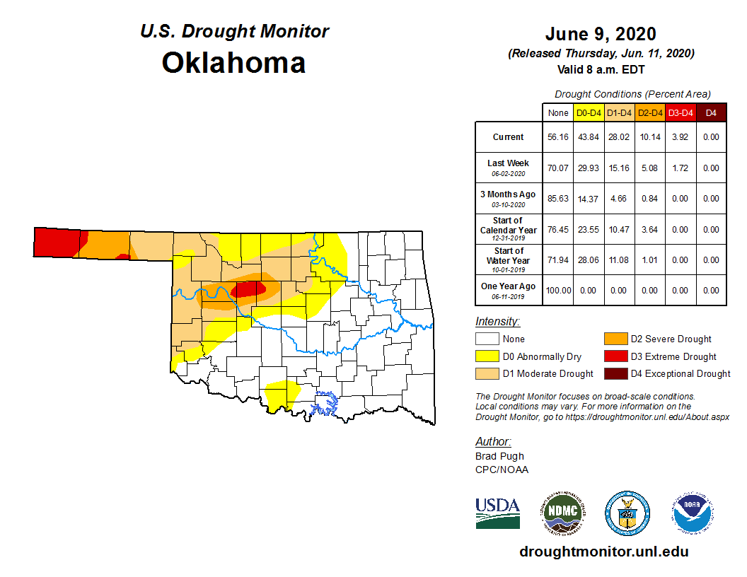
 Extreme drought (D3) has become a part of the 2020 reality this week for folks in west central Oklahoma. All year we have been talking about D3 in the Oklahoma Panhandle, specifically Cimarron County. A lack of precipitation has now created a serious situation for thousands of more Oklahomans as the latest U.S. Drought Monitor map shows extreme drought conditions now cover almost 4 percent of the state, more than twice the area covered last week.
Almost half of Oklahoma, 43.8 percent, is considered abnormally dry or worse. This is now the longest stretch of dry conditions for this much of Oklahoma in more than a year.
According to the Oklahoma Mesonet, nearly all the northwestern quarter of Oklahoma has seen a top-10 driest the last 60 days, dating back to at least 1921. For the Panhandle climate division, it's the 3rd driest.
Specifically, Cimarron County is completely colored in red (D3), while parts of Texas, Dewey, Blaine and Kingfisher Counties are showing red spots.
Abnormally dry shades extend all the way east into Osage and Creek Counties. Much of Jefferson and Carter Counties are also showing abnormally dry conditions.
If you're looking for some good news, no exceptional drought (D4) is showing anywhere in Oklahoma. Also, Oklahoma has plenty of company as more than 38 percent of the country is experiencing abnormally dry or worse conditions. This covers more than 23 million people in the continental U.S.
Above normal temperatures combined with periods of strong winds have resulted in rapidly worsening conditions. Trinidad, in southern Colorado, recorded only 1.66" of precipitation year-to-date which is the driest January to June period on record. Data for this region dates to 1948.
The intensifying and developing drought conditions across Colorado, New Mexico and Oklahoma also extend into the southern two-thirds of Kansas.
Making matters worse, a strong upper-level ridge has developed over the southwest and expanded east into the Great Plains.
During a relatively wet time of year, precipitation has averaged less than 50 percent across much of western Oklahoma and the Texas Panhandle.
USDA's National Agricultural Statistics Service stated topsoil moisture is rated as short or very short across Oklahoma increasing from 23 to 53 percent during the past week.
The short-term outlook is not helping much as along with the dry weather, a return of above normal temperatures is expected across the central and southern Great Plains. There are also increased chances of below normal precipitation for the Mississippi Valley, Corn Belt and Gulf Coast regions.
To view the Oklahoma drought map, click here.
To view the latest U.S. Drought Monitor map, click here.
The U.S. Drought Monitor Map is developed through a partnership between the National Drought Mitigation Center at the University of Nebraska-Lincoln, the United States Department of Agriculture, and the National Oceanic and Atmospheric Administration.
WebReadyTM Powered by WireReady® NSI
Top Agricultural News
More Headlines...


