

Agricultural News
The Latest Fire Situation Report for Oklahoma Shows Burn Bans for Cimarron, Texas, Beaver, Alfalfa, Major &
Thu, 18 Jun 2020 08:53:43 CDT
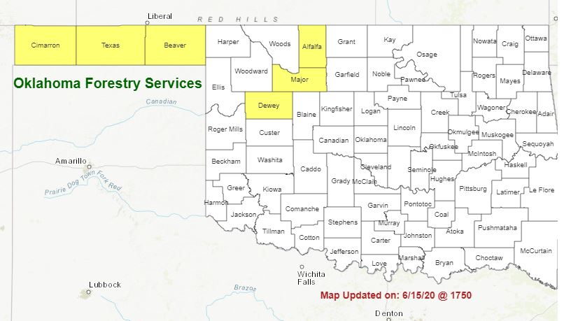 Looking at The latest Fire Situation Report for June 18, for the State of Oklahoma Shows Burn Bans in Cimarron, Texas, Beaver, Alfalfa, Major & Dewey Counties.
Scattered light showers this morning in parts of western Oklahoma will dissipate rapidly with daytime
heating offering little or no relief from fire danger building into the afternoon. Dry conditions continue today ahead of a slow
moving cold front that will usher in storm chances later this afternoon in the Oklahoma Panhandle and far northwestern
Oklahoma shifting into western Oklahoma this evening. Initially, isolated storms may develop and the associated cloud to
ground lightning may spark new wildfires that will be subjected to outflow winds. Lightning activity level increases into the
nighttime hours along with probability of increasing rainfall intensity that should mitigate lightning ignition overnight.
Today: Hot and dry conditions persist today in advance of an approaching cold front although slightly improved afternoon
relative humidity values and somewhat lighter winds are forecasted overall. Isolated thunderstorm potential in the Panhandle
and northwestern counties increases into the afternoon meriting vigilance for new fire starts. Although general winds are
expected to be less intense than in previous days, the approaching cold front will result in southerly winds shifting clockwise to
the north and going fires in the vicinity of a thunderstorm may be subjected to outflow winds inducing erratic fire behavior.
· Oklahoma Panhandle/Northwestern Oklahoma: Marginal overnight moisture recovery will facilitate early development
of the burning period today as temperatures warm to 90?-98? with afternoon relative humidity values 18-30%. Heavily
stressed live-fuel moisture and fine-dead fuel moisture values 3-4% results in very receptive fuels.
The approaching cold front arriving in the western Panhandle later this morning is expected to slow creating an environment conducive
to thunderstorm development with those early, isolated storms posing a threat to initiate lightning ignited wildfires.
Southerly winds will be sustained 10-17 mph with some gusts in excess of 20 mph are expected although general
winds will shift from southerly to northerly with the frontal passage decreasing in intensity in the post-frontal
environment. Firefighters should expect locally, gusty outflow winds near storm development. Typical fuels will exhibit
head fire rates of spread 85-130 ft./min. with flame lengths 9-12 ft. as well as problematic fire behavior in heavier brush
fuels. Erratic fire behavior including abrupt changes in spread direction, rate of spread and fireline intensity should be
anticipated on any going fire subjected to outflow winds associated with thunderstorms.
· Western/ West-Central Oklahoma: Hot and dry conditions are expected to continue through the day today with rain
and storm chances increasing into the late evening and overnight hours. Temperature will warm into the 93?-97? with
afternoon relative humidity values 28-35%. South winds sustained 10-20 mph with some higher gusts will drive rates
of fire spread 75-120 ft./min. and head fire flame lengths 8-10 ft. Dry fuels will continue to exhibit resistance to control
requiring extended resource commitment to obtain control.
· Central/Eastern Oklahoma: Fire occurrence has increased in recent days given the separation from wetting rains,
although fires have been contained successfully during initial attack. Hot and dry conditions today will again result in
above normal fire danger for the season, although initial attack success is continued to be successful.
Short-term Outlook: Wetting rains are forecasted over the drought-stricken Panhandle and northwestern counties with some
promise of reprieve from fire danger in the short-term. However, fuels have been stressed registering unseasonable live-fuel
moisture and concerning composite fuel moisture values. A thorough evaluation of the fuels and wildfire potential will be
conducted in the wake of the cold front passing through Oklahoma this afternoon and overnight.
Resources: Duty Officer (800) 800-2481
· OFS has 1 Task Force available from Woodward and additional availability from OFS Protection Area
· OHP/OFS aerial reconnaissance
· ONG 1 Helicopter
· OEM in support
Note: OFS/ODAFF has personnel mobilized in support of ESF-8 Public Health
Burn Bans: Cimarron, Texas, Beaver, Alfalfa, Major & Dewey Counties
WebReadyTM Powered by WireReady® NSI
Top Agricultural News
More Headlines...


