

Agricultural News
Drought Continues to Degradate the West and Northwest While Other Regions Experience July Heat
Thu, 29 Jul 2021 08:51:46 CDT
 Southwestern monsoon circulation delivered drought-easing rainfall but sparked localized flash flooding across large sections of the Four Corners States, as well as the southern Great Basin, but critically dry conditions persisted across northern California and the Northwest.
Farther east, another round of blistering heat across the northern Plains further stressed rangeland, pastures, and a variety of summer crops. The central and southern Plains also experienced some hot weather, although agricultural impacts were tempered by mostly adequate soil moisture reserves.
Meanwhile, mostly dry weather covered the Midwest, continuing a trend that had developed in mid-July. Short-term dryness was not yet a concern in the previously well-watered lower Midwest. However, reproductive corn and soybeans in drier areas of the upper Midwest were subjected to increasing levels of stress, especially as temperatures began to rise.
Elsewhere, Southeastern rain which maintained abundant moisture reserves for pastures and summer crops primarily fell from the Mississippi Delta to the southern Atlantic Coast.
Arkansas, Louisiana, and Mississippi remained free of dryness and drought, while only small patches of abnormal dryness (D0) and moderate drought (D1) were noted in Oklahoma, Texas, and Tennessee. Most Southern crops continued to fare well amid plentiful rainfall and relatively mild temperatures.
Moving into next week, the Climate Prediction Center six-to-10 day outlook (valid July 20-24) predicts large sections of the central and southern Plains will remain mostly dry, accompanied by some of the hottest weather of the summer.
Near-or below-normal rainfall across most of the United States that should contrast with wetter-than-normal weather in a few areas, including the Southern Plains and Northeast.
To view the U.S. Drought map, click here.
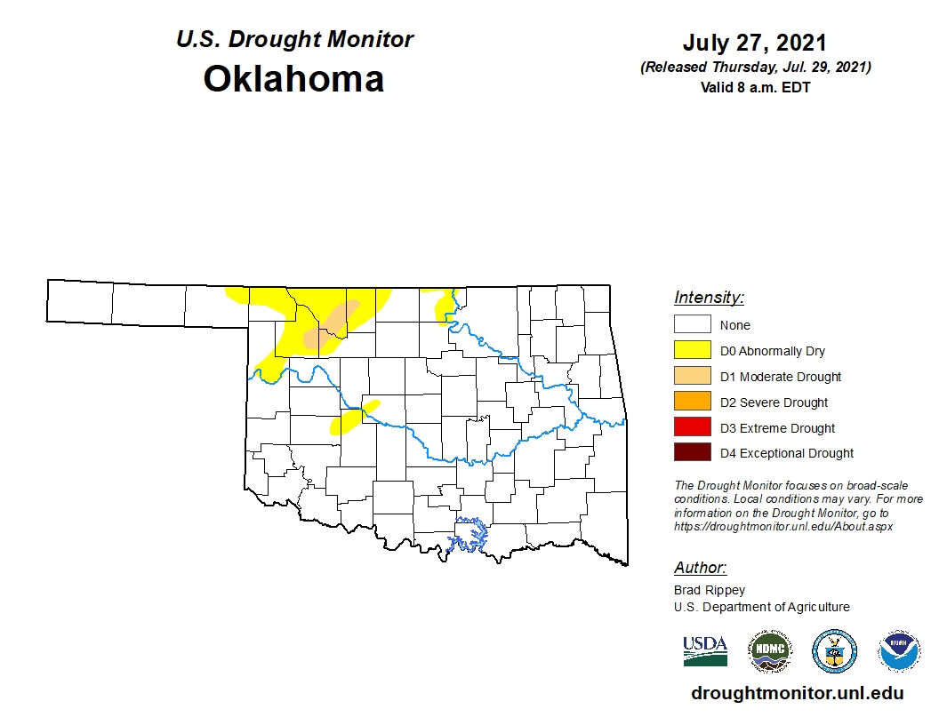
In Oklahoma, 91.45 percent of the state remains drought free. This compares to 43.60 percent three months ago and 39.83 percent one year ago.
Though there is a patch of yellow (D0 abnormally dry) in the northwest part of the state, there are no shades of bright orange (D2 severe drought) and very little light orange (D1 moderate drought) on the Oklahoma map this week.
To view the Oklahoma drought map, click here.
Going into next week, temperatures are predicted to remain below normal for the entire state and surrounding areas, particularly east of Oklahoma.
Precipitation is expected to remain normal for the Panhandle and central part of the state, while the southwestern region has the probability of above average and the eastern half of the state looks to be slightly below normal.
To view the 6-10-day temperature outlook, click here.
To view the 6-10-day precipitation outlook, click here.
A normal to slightly below average summer, precipitation-wise, is now forecast by NOAA for much of the Oklahoma. To view this three-month outlook, click here.
The NOAA expects little-to-no drought for the majority of Oklahoma into the eastern half of the U.S.
Unfortunately, the drought will continue to persist and scorch much of the western, high plains and southwestern U.S.
To view the new seasonal drought outlook map, click here.
The U.S. Drought Monitor Map is developed through a partnership between the National Drought Mitigation Center at the University of Nebraska-Lincoln, the United States Department of Agriculture, and the National Oceanic and Atmospheric Administration.

WebReadyTM Powered by WireReady® NSI
Top Agricultural News
More Headlines...

