

Agricultural News
Latest U.S. Drought Monitor Map Shows Oklahoma Is Experiencing a Mild Summer
Thu, 12 Aug 2021 18:50:01 CDT
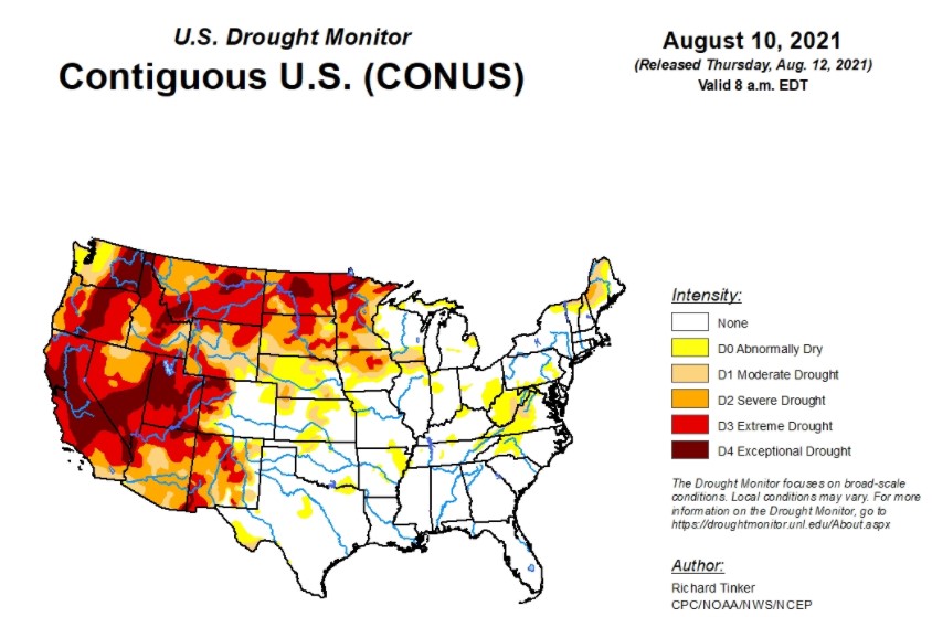 Monsoonal precipitation was muffled this week, compared to the heavy rainfall that had been pelting the southern Rockies and - to a lesser extent - much of the interior West. Between 1 and 2 inches were limited to a few patches in central and south-central New Mexico and scattered higher elevations in central Colorado and central Montana, according to the latest U.S. Drought Monitor.
Much of eastern Colorado, southern Nebraska, Kansas and northwest South Dakota received well over 150 percent of normal precipitation during the period.
In the southern plains, drought coverage continued to increase from last week. New or expanded patches of 'abnormally dry' drought conditions dotted Tennessee, Oklahoma, and Texas. Limited precipitation fell on Colorado and Wyoming, but decreased impacts and localized moderate rains led to 1-category improvements in central Colorado and southwestern Wyoming. Little or no precipitation fell on most of the West, and drought intensity remained unchanged from last week in most areas.
To view the U.S. Drought map, click here.
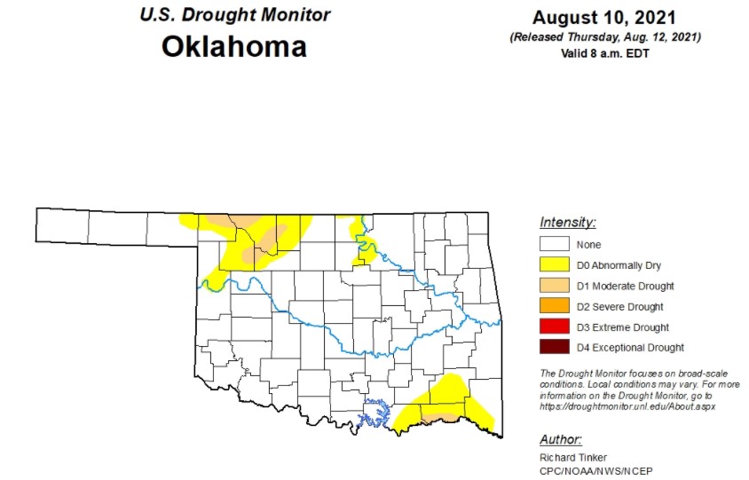
In Oklahoma, nearly 14% of Oklahoma experienced abnormally dry conditions - mostly in the northwestern and southeastern areas of the state. Woods County saw the most severe conditions, with about half the county experiencing abnormally dry and moderate drought conditions, followed by Alfalfa, Choctaw, Harper, Major and Woodward counties with areas of moderate drought. Parts of Beaver, Bryan, Ellis, Grant, Kay, Osage, McCurtain, Noble, Pawnee, Pushmataha counties saw areas of abnormal dryness. Drought conditions are increasing in Oklahoma, compared to last week, but are not close to what conditions were this time last year.
Temperatures and rainfall in Oklahoma are expected to be higher than normal for this time of year, according to the National Oceanic and Atmospheric Administration (NOAA).
To view the Oklahoma drought map, click here.
In the next four days, Oklahoma is expected to see moderate to heavy rains, with rainfall inches anywhere between 1.5 to 4.0 inches. From August 17 to 21, mild conditions are favored in the Southwest, much of the Rockies and the southern High Plains.
To view the 6-10-day temperature outlook, click here.
To view the 6-10-day precipitation outlook, click here.
As summer moves into fall, forecasts show much of Oklahoma experiencing normal amounts of precipitation, with the panhandle possibly experiencing lower-than-normal precipitation, according to NOAA.
To view this outlook, click here.
Unfortunately, for the areas of the state expierencing drought, NOAA expects drought conditions to persist throughout the month of August.
To view the new seasonal drought outlook map, click here.
The U.S. Drought Monitor Map is developed through a partnership between the National Drought Mitigation Center at the University of Nebraska-Lincoln, the United States Department of Agriculture, and the National Oceanic and Atmospheric Administration.
WebReadyTM Powered by WireReady® NSI
Top Agricultural News
More Headlines...

