

Agricultural News
Latest Drought Monitor Report Shows More Wet and Wild Weather Ahead for Oklahoma
Thu, 14 Oct 2021 15:44:28 CDT
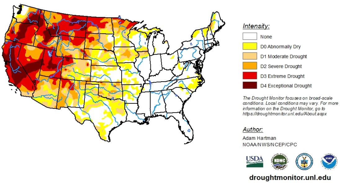
 According to the latest U.S. Drought Monitor report, a spanning weather system resulted in seasonal to below-normal temperatures across the western third of the United States. A high-pressure system dominated the eastern two-thirds of the country, leading to above-normal temperatures, with the greatest anomalies across the Northern Plains and Midwest. These whether systems conflicted in the middle of the country, bringing severe weather to Oklahoma, Kansas and the Midwest.
In the last week, much-needed precipitation fell over the Plains, with the largest improvements of abnormally dry conditions or worse in the Dakotas. Conditions largely worsened in Colorado.
Cooler-than-normal temperatures and beneficial rains visited much of the West, but improvements were mainly limited to portions of the Pacific Northwest and Four Corners. Still, areas in the West continue to see drought conditions remain or degrade.
To view the Contiguous U.S. Drought Map, click here.
The next week is expected to bring heavy rainfall to the Northern Plains and Upper Midwest. That storm system is expected to clash with remnants of Tropical Depression Pamela, bringing a surge of moisture to the Southern Plains. In the next 6 - 10 days, below-normal precipitation is expected for most of the eastern two-thirds of the U.S. Above-normal amounts of rain are expected to cover most of the West Coast states and western Nevada. Much of western Texas is expected to see above-normal amounts of rain also.
To view the 6 - 10 Day Precipitation Outlook, click here.
The 6-10-day Temperature Outlook map shows higher-than-normal temperatures for all of the contiguous U.S. except for an area radiating out of southern California, into western Arizona and southwestern Nevada.
To view the 6 - 10 Day Temperature Outlook, click here.
Drought removal is likely for much of the Pacific Northwest, Southern and Central Plains and upper Midwest. Drought is expected to persist in the remaining parts of the West and will dominate Montana and much of the Dakotas.
To view the Monthly Drought Outlook map, click here.
Oklahoma
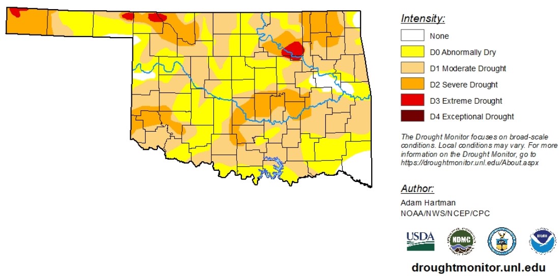
In the last week, much-needed precipitation fell over the southern plains, decreasing percentages of moderate drought or worse all over the state. Still, as of Oct. 12 much of the state continues to battle flash drought, with 95% of the state experiencing abnormally dry conditions or worse. In the last week, moderate drought conditions or worse decreased from 69% to 62%. Extreme drought conditions still has a hold of areas in the panhandle, the Tulsa area and northwestern parts of the state. Despite the rain Oklahoma has recently received, conditions in southeastern Oklahoma degraded.
Looking ahead, Oklahoma may get more wet and wild weather as an expected storm system in the Northern Plains merges with remnants of Tropical Depression Pamela. The next 6 - 10 days are expected to bring higher-than-normal temperatures for this time of year. The western half of Oklahoma is expected to get average to above-average amounts of precipitation for this time of year, while the eastern half of the state will most likely see below-average amounts of precipitation for this time of year.
According to Tuesday's U.S. Crop Progress report, Oklahoma wheat is 50% planted and 25% emerged.
To view the Oklahoma drought map, click here.
WebReadyTM Powered by WireReady® NSI
Top Agricultural News
More Headlines...

