

Agricultural News
Latest Drought Monitor Report Shows Drought Conditions Improve in Eastern Oklahoma
Thu, 21 Oct 2021 14:19:28 CDT
 According to the latest U.S. Drought Monitor report, a large weather system resulted in widespread precipitation from the central Rockies to much of the Great Plains. More than a foot of snow blanketed parts of Montana, Wyoming and western South Dakota. Heavy to excessive rainfall occurred across the eastern halves of Oklahoma and Texas.
The previously mentioned weather system improved drought conditions in the High Plains. The most noticeable improvements can be seen in the severe and extreme drought condition categories. As of Oct. 19, 2021, severe drought conditions in the High Plains decreased from 40% to 32% and extreme drought conditions in the High Plains decreased from 17% to 8%. In the Southern Plains, drought conditions are also beginning to improve, starting in eastern Oklahoma. Conversely, drought conditions expanded in west Texas.
The wet season is beginning in the West, bringing snow, to the coastal and Sierra Nevada mountain ranges. This favorable start to the wet season is credited with improving streamflows and Standard Precipitation Index (SPI) values. The increase in precipitation related to the onset of the wet season, along with much cooler temperatures, resulted in a large decrease in the number of large wildfires throughout the West during mid-October. Despite all this, drought conditions did not change in the West, with 91% of the region experiencing moderate drought conditions or worse, according to data as of Oct. 19, 2021.
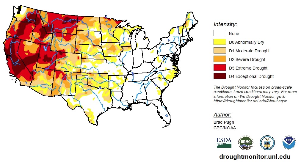
To view the Contiguous U.S. Drought Map, click here.
From Oct. 21 to 25, 2021, the corn belt and the Pacific Northwest are forecast to receive the most precipitation. Little-to-no precipitation is expected for much of the Great Plains, Southwest, Gulf Coast States, and East Coast.
From Oct. 26 to Oct. 30, above-normal precipitation is likely in the Pacific Northwest, down to northern California and over to the Great Basin. Dry weather is expected to dominate the last days of October across the Great Plains. Along with the dry weather for the southern Great Plains, a return of above-normal temperatures is forecast.
To view the 6 - 10 Day Precipitation Outlook, click here. To view the 6 - 10 Day Temperature Outlook, click here.
According to the Monthly Drought Outlook map, drought condition improvement and removal is likely for much of the Pacific Northwest, Southern and Central Plains and upper Midwest. Drought is expected to persist in the remaining parts of the West and will dominate Montana and much of the Dakotas.
To view the Monthly Drought Outlook map, click here.
Oklahoma
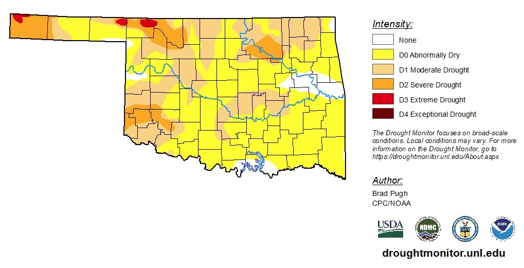
According to data as of Oct. 19, 2021, drought conditions improved in eastern Oklahoma. Although nearly 94% of the state is experiencing abnormally dry conditions or worse, moderate drought conditions decreased from 62% to 38%, severe drought conditions decreased from 19% to 10% and extreme drought conditions decreased from 1.52% to 0.77%. Despite improving conditions in the eastern half of the state, the Tulsa area continues to experience severe drought conditions. The western half of the state continues to be dry. Extreme drought conditions are still gripping areas in northwestern Oklahoma and the Panhandle, in Beaver, Cimarron, Harper and Woods counties.
The next five days are expected to bring little rain and temperatures are expected to be higher than normal for this time of year. The 6-to-10-day precipitation outlook map shows eastern Oklahoma is likely to receive above-normal precipitation, the central column of the state is likely to receive normal precipitation and western Oklahoma is likely to receive below-normal precipitation. The 6-to-10-day temperature outlook map shows Oklahomans are almost guaranteed higher-than-normal temperatures for this time of year.
To view the Oklahoma drought map, click here.
WebReadyTM Powered by WireReady® NSI
Top Agricultural News
More Headlines...

