

Agricultural News
Latest Drought Monitor Report Shows Rain Improving Drought Conditions in Eastern Oklahoma
Thu, 04 Nov 2021 10:53:34 CDT
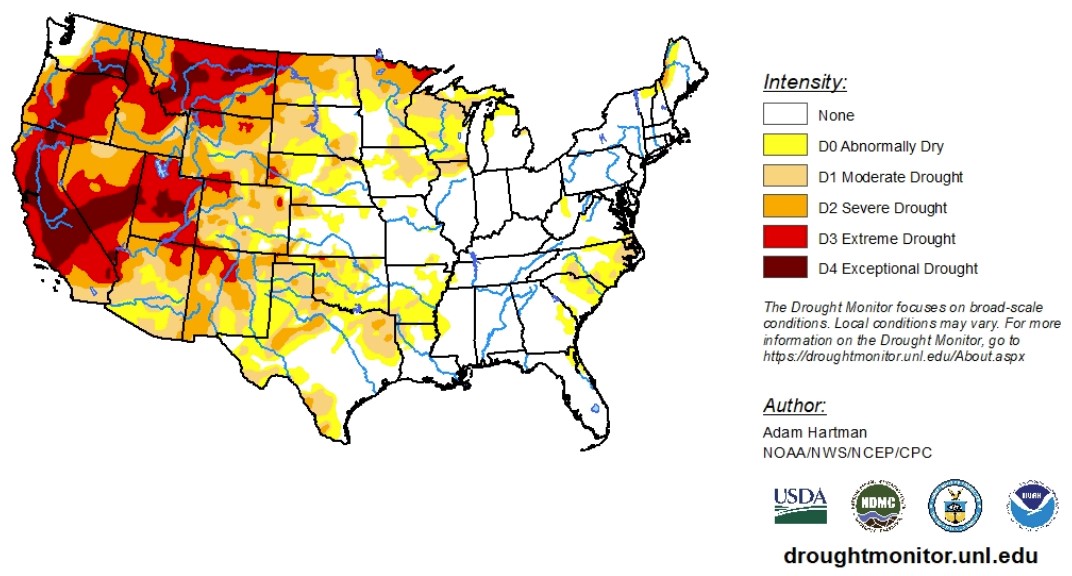
 According to the latest U.S. Drought Monitor report, the eastern half of the country got rain, with the parts of the Central Plains receiving up to two inches in some areas. Drought conditions are reported to have improved in areas that got the most precipitation. The Northwest also saw improvements thanks to a weather system in the Pacific Northwest.
While drought conditions begin to slowly improve, long-term deficits remain intact and groundwater and reservoir levels remain well below normal. Some localized degradations were warranted in Montana, east of the Front Range, and in the Southern Plains, as above-normal temperatures and high wind events have helped to worsen ongoing drought in those areas.
With data ranging from Oct. 27 to Nov. 2, 2021, we know rains in the South stayed to the east and avoided Texas. Above-normal temperatures and high winds associated with the exiting low-pressure system resulted in increased evaporative demand across much of eastern Texas. Despite the rainfall, there was even a report of a wildfire near Rusk County, Texas. Farther west across the Southern High Plains, conditions also deteriorated, resulting from moderate drought to extreme drought-equivalent 30-90-day Standardized Precipitation Indices (SPIs), widespread NASA SPoRT soil moisture rankings below the 10th percentile, below-normal precipitation, and above-normal temperatures.
According to the report, many areas in the High Plains region saw improvement in drought conditions. In eastern portions of the High Plains, above-normal precipitation led to one-category improvements. This region has also benefited from improved soil moisture in recent weeks as the storm track remained active during October. Across the western Dakotas and parts of Wyoming, improvements were also warranted, despite rainfall lacking for many locations, as drought indicators have continued to improve due to many locations receiving more than 200% of normal precipitation since the beginning of October. Soil moisture and short-term rainfall deficits are much improved for most areas. However, while ground reports corroborate the improved soil conditions, they also indicate that rangeland conditions are slow to recover and stock ponds remain below normal with poor water quality, indicative of longer-term hydrologic deficits.
In the West, drought conditions continue to slowly improve, especially in the Pacific Northwest and northern California. Because of an atmospheric river event in late Oct., northern California and the central Great Basin dropped record 24-hour precipitation in several locations. From Oct. 27 to Nov. 4, 2021, soil moisture and stream flows have improved greatly in the Great Basic region, trickling down improvements to southern Idaho, northeastern Nevada and northern Utah. The snowpack has begun to build across the northern Rocky Mountains, the Cascade Range and parts of the Sierra Nevada.
At the same time, exceptional drought expansion was warranted in central Montana, as stream flows have fallen below the second percentile, NASA SPoRT and CPC soil moisture have fallen below the 2nd percentile, vegetation indices show increased stress, and 30-60-day SPIs have fallen to exceptional drought levels. In addition, parts of this new D4 area have experienced a record dry period spanning September to October. The timing of this dryness has also stunted winter wheat growth in the region. Status quo was warranted elsewhere in the West as antecedent 30-day wetness and improved soil moisture offsets the observed above-normal temperatures for the seven-day period.
To view the Contiguous U.S. Drought Map, click here.
Looking at the next four days, the southwestern, central and eastern U.S. is expected to remain dry. The Pacific Northwest is expected to get more rain, spanning from Washington to the Cascade Range and northern California. Drought conditions are likely to remain but improve here also, from Washington, down to northern California and up and over to northeastern Montana. Maximum temperatures are expected to remain below-normal across the West Coast and above-normal across much of the central U.S.
From Nov. 8 to Nov. 12, 2021, temperatures are expected to remain higher-than-normal in the central and eastern U.S. and precipitation levels are expected to be lower-than-normal in the Southwest.
To view the 6 - 10 Day Precipitation Outlook, click here.
To view the 6 - 10 Day Temperature Outlook, click here.
According to the Monthly Drought Outlook map, drought condition improvement and removal is likely for much of the Pacific Northwest. In the remainder of the West and Great Plains, drought is expected to persist or further develop.
To view the Monthly Drought Outlook map, click here.
Oklahoma
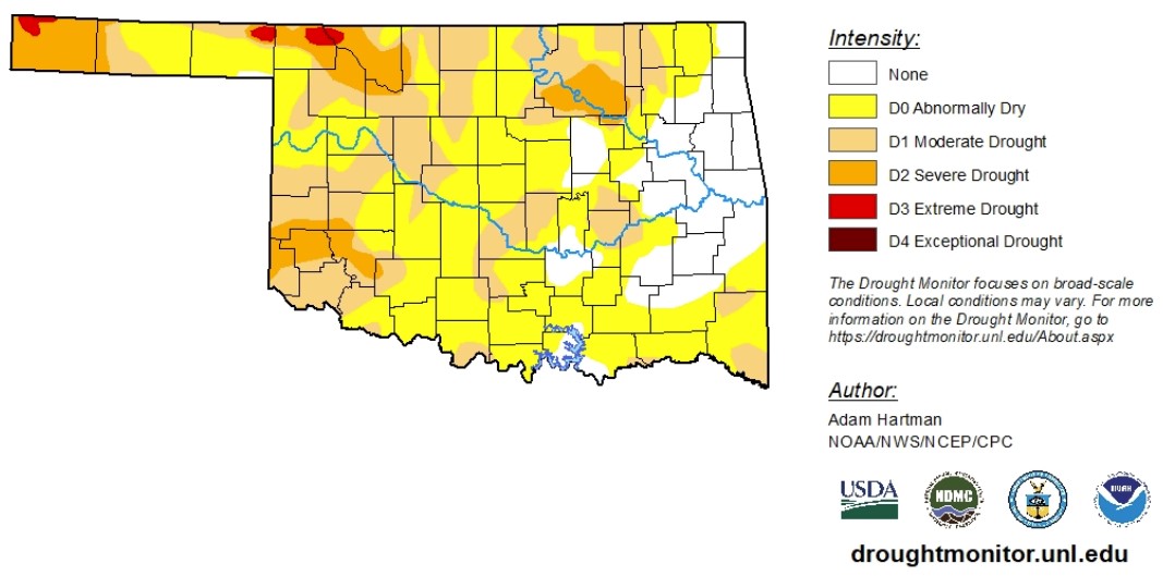
The last drought monitor week, saw rainfall improve drought conditions across much of eastern Oklahoma, with some locations receiving more than 150% of normal precipitation during the seven-day period. At the same time, high winds and higher-than-normal temperatures helped drought conditions persist across much of the state.
According to data as of Oct. 27, to Nov. 2, 2021, drought conditions in Oklahoma have slightly improved. Extreme drought conditions did not change since last week's Drought Monitor report. Severe drought conditions improved just a 10th of a percent. Moderate drought conditions or worse decreased from 40.7% to 36.8%. Abnormally dry conditions or worse decreased from 94.9% to 82.1%. Extreme drought conditions remain in Beaver, Cimarron, Harper and Woods counties. Severe drought conditions remain in the Panhandle, northwest and southwest areas in the state and the Tulsa area.
The 6-to-10-day precipitation outlook map shows eastern Oklahoma is likely to receive above-normal precipitation, while western Oklahoma is set to receive normal-to-low amounts of precipitation. The 6-to-10-day temperature outlook map shows Oklahomans can expect higher-than-normal temperatures for this time of year.
To view the Oklahoma drought map, click here.
WebReadyTM Powered by WireReady® NSI
Top Agricultural News
More Headlines...

