

Agricultural News
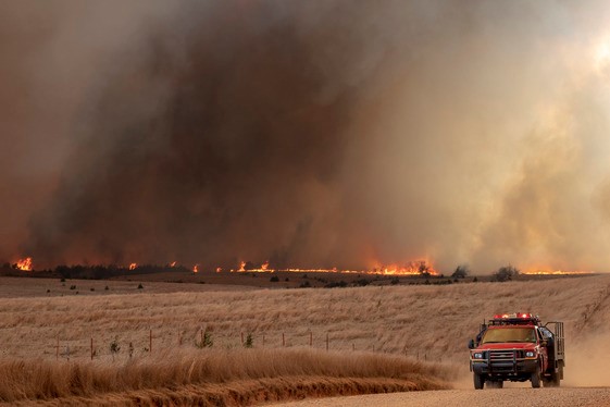
Thursday, December 16, 2021, Fire Situation Report: Four New Wildfires Burning in Western Oklahoma
Thu, 16 Dec 2021 11:51:53 CST
 According to Thursday's Fire Situation Report from the Oklahoma Forestry Services, firefighters are battling four new fires:
· Wolf Mountain Fire has burned 120 acres in LeFlore County and is 60% contained.
· Cobb Fire has burned an estimated 10,000 acres and razed two structures in Texas County and is 25% contained.
· 640 Fire has burned 630 acres in Alfalfa County and is 30% contained.
· Stonehill Fire has burned 350 acres in Wagoner County and is 65% contained.
Yesterday's Bigfoot Mt. Fire in Cherokee County is 100% contained.
Statewide Discussion: Much cooler temperatures today on the heels of a cold front that presented a very challenging fire environment yesterday. That cold front provided wetting rains in parts of northeastern Oklahoma and will offer some opportunity for showers in southeastern Oklahoma as the frontal boundary exits the state. With cooler temperatures, lighter winds and rainfall potential in eastern Oklahoma, moderated fire danger is expected over the next few days.
Today: Dry, post-frontal air will sink into western Oklahoma and central counties although much cooler temperatures and lighter winds will temper fire behavior today. Overnight rainfall in northeastern Oklahoma and continuing opportunity southeast will hold concerning fire danger at bay. Overall, very good opportunities today to boost containment on fires from yesterday.
· Western Oklahoma: Following a chilly start, temperatures will gradually warm into the low- to mid-50?'s under partly cloudy to mostly clear skies and afternoon relative humidity values will register 17-25%. Fine fuels will be receptive with 1 Hr. fuel moisture values generally 6%. Somewhat light and variable winds early this morning will become light northeasterly this morning before shifting back to southerly this afternoon and evening. When those winds do shift to become southerly, expect an increase in wind speed to 10-15 mph with some higher gusts. Rangeland fuels will support fire behavior much less intense than yesterday with head fire rates of spread 100-140 ft/min and flame length 9-12 ft. Winds will again taper off after sunset as temperatures cool and overnight moisture recovery will be marginal to good. Resources Committed: Resource Hotline (800) 800-2481.
Friday: Precipitation chances along and south of I-44 will stall development of fire danger concerns in that area while dry conditions persist in most of western Oklahoma extending dryness. Again, rather light winds will hold concerning rates of fire spread in check. Moderate fire danger indices will span across far northwestern and far western Oklahoma where temps will be in the 50?'s and low 60?'s with afternoon relative humidity values 19-29%. Winds will be variable in direction with sustained wind speeds in the afternoon 8-15 mph. Rates of fire spread will be well within the range supportive of successful initial attack.
Near Term: A brief period of near normal temperatures will gradually give way to another warning trend. Given current forecast information, no critical fire danger or significant fire potential is expected into next week. La Nina influence remains strong with above normal temperatures and below normal precipitation trends continuing. There is little to no potential for wetting precipitation in the next 7 days generally north of I-44. Western Oklahoma, generally north of I-44 has little to no expectation for precipitation in the next 7 days with wetting amounts relegated to southeast Oklahoma. Given current forecast information, no significant or critical fire occurrence/fire danger is expected in the near term.
WebReadyTM Powered by WireReady® NSI
Top Agricultural News
More Headlines...


