

Agricultural News
Tuesday, January 11, 2022, Fire Situation Report: Two Fires Burn 28 Acres
Tue, 11 Jan 2022 08:38:36 CST
 According to the latest Fire Situation Report from the Oklahoma Forestry Services, two small fires in southeastern Oklahoma burned 28 acres.
Statewide Discussion: Relative humidity values yesterday afternoon dipped lower than forecast promoting very strong drying conditions. With low relative humidity values and increased winds compared to yesterday, fire danger indices will ratchet up across the state this afternoon especially along and north of I-44. Initial attack success is still expected to be successful with limited large fire potential and low significant fire potential. Prescribed fire activity is expected to occur in the coming days noting that a stronger cold front, and elevated fire danger indices, are expected Friday afternoon.
Today: Dry air will overspread the state again today with afternoon relative humidity values again dropping below 30%, and with single digit dew point temperatures in the western Panhandle relative humidity values in the low-teens are likely. Unlike the relatively calm conditions yesterday, southwest winds will be a more noticeable today ahead of a shift to northwest winds late this evening in the Panhandle and far northwest Oklahoma.
· Oklahoma Panhandle: A cool start with moderate overnight moisture recovery will give way to temperatures warming to 58?-62? and relative humidity values 11-18% under mostly-clear skies yielding fine-dead fuel moisture values 4-5%. Southwest winds sustained 11-16 mph with some higher gusts will encourage moderate rates of fire spread in rangeland fuels. Head fire rates of fire spread 131-190 ft/min with flame lengths 11-13 ft should be expected. Late this afternoon winds are expected to shift to the northwest diminishing in intensity with sunset.
· North/West of I-44: Temperatures 55?-59?, partly cloudy skies and afternoon relative humidity values 19-28% will yield another day of very receptive fuels with 1-hr. fuel moisture values at 6% across most of the area. South to southwest winds sustained 15-19 mph with some higher gusts will support rates of fire spread 165-195 ft/min with head fore flame length 11-14 ft. Mixed fuels (grass/shrub/timber) will exhibit ROS 74-115 ft/min with flame lengths 15-20 ft.
· South of I-44: Surprisingly strong drying conditions yesterday will be followed by another day of very dry conditions in the area. Temperatures 56?-59 and relative humidity values 25-30% will support fine-dead fuel moisture values at 7% widely and 6% localized. Some cloudiness is expected along the Red River this afternoon which may serve to boost 1-hr fuel moisture values by a percent or so. Southwest winds 7-15 mph with some higher gusts will support moderate rates of fire spread in grass-dominated fuels at 97-145 ft/min with flame lengths 14-18 ft. Timber-litter fuels will exhibit ROS around 20 ft/min with FL around 4 ft.
Wednesday: Winds will continue to shift to the west then northwest through the day although temperatures will again push into the upper-50?'s / low-60?'s. Relative humidity values north and west of I-44 will range from the teens in the Panhandle to around 30% along the interstate and then 30-36% east. In general, winds will be lighter than today resulting in reduced fire spread potential with range/grass dominated fuels at less than 110 ft/min.
Near Term: No precipitation in Oklahoma indicated in the current 7-day Quantitative Precipitation Forecast. Drought intensity has again increased in spatial coverage, even at a time in the year where dry conditions are the norm. Currently, no critical fire weather appears in the near-term forecast although a somewhat stronger cold front on Friday will increase observed fire behavior d suppression difficulty elevating large fire potential, or those fires greater than 300 acres in grass-dominated fuels.
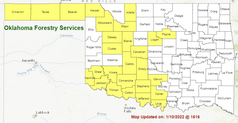
See the map above for the latest list of Oklahoma counties under burn bans.
WebReadyTM Powered by WireReady® NSI
Top Agricultural News
More Headlines...


