

Agricultural News
Friday, January 14, 2022, Fire Situation Report: Red Flag Warning in Effect
Fri, 14 Jan 2022 09:41:57 CST
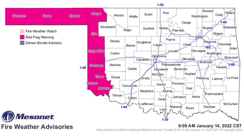 According to the latest Fire Situation Report from the Oklahoma Forestry Services, a red flag warning is in effect today until 7 p.m. for the Oklahoma Panhandle and western tier of counties along the 100th Meridian.
Four fires in southeastern Oklahoma burned 49 acres.
Statewide Discussion: Ahead of a strong cold front, temperatures will again warm to above normal with very dry fuels in place marginal to poor overnight moisture recovery. In the warned area, light south winds this morning will shift rather abruptly to the west then north later this afternoon with north winds sustained 30-40 mph with gusts in excess of 50 mph at times. Ahead of the front, sky cover will limit 1-hr fuels from tapping critical values although any going fire during frontal passage will likely exhibit problematic fire behavior and rapid rates of fire spread. Conditions are expected to moderate gradually behind the front as temperature cools and relative humidity increases after sunset.
Today: As previously described, wildfire potential will quickly ramp up in the west later this afternoon as a cold front approaches placing concern firmly in the Warned Area and adjacent counties. To the east of the Warned Area, increasing sky cover will serve to limit carrier fuel receptiveness and moderate winds will hold potential rates of fire spread below the very concerning level. Nonetheless, some problematic fire behavior should be anticipated given fuel dryness in the pre-frontal fire environment.
· Warned Area: Temperature will warm into the 50?'s north to upper-60?'s south ahead of a strong cold front that will arrive in the Oklahoma Panhandle early this afternoon progressing into the main body of the state later this afternoon. Relative humidity values will be lowest in southwest Oklahoma where 17% observations may be realized with 20-30% observation in the bulk of the area. Sky cover ahead of the front will likely hold fine-dead fuel moisture values above the critical level at 6-7% although composite fuel dryness remains concerning. Ahead of the front, south winds sustained 10-15 mph will support moderate rates of spread although with the quickly approaching cold front winds will intensify shifting to the north. Firefighters should anticipate any going fire to exhibit problematic and extreme fire behavior on the eastern and southern fire lines. Rates of spread in rangeland fuels during frontal passage at 270-310 ft/min (+/- 3 mph) with flame lengths 15- 18 ft.
· Central/Eastern Oklahoma: Conditions will be moderated compared to those in the Warned Area. Temperatures on the 60?'s and relative humidity values 27-40% under mostly cloudy skies will hold fine-dead fuel moisture values at or above 7%. Southerly winds 10-17 mph with some higher gusts will support rates of spread at 106-127 ft/min with flame lengths around 10 ft on established fires. Cold front arrival will come late this evening into the overnight hours lacking the alignment to drive higher concern.
Weekend: While western Oklahoma will remain very dry, a dusting to light snow is expected Friday night through Saturday in the eastern half of the state. With strong winds in place west, fire danger concerns remain firmly in place despite much cooler temperatures especially on Saturday. In western Oklahoma, temperatures 34?-40? and afternoon relative humidity values 24-35% under partly cloudy skies will yield fine-dead fuel moisture values at 7%. North winds sustained 23-33 mph with some gusts over 40 mph will support potential for rapid rates of fire spread 200-250 ft/min. Conditions do moderate somewhat on Sunday with much calmer winds holding spread potential below those frustrating values Friday afternoon and Saturday.
See the map above for the latest list of Oklahoma counties under red flag warnings. Click here to see a list of counties under burn bans.
WebReadyTM Powered by WireReady® NSI
Top Agricultural News
More Headlines...


