

Agricultural News
Oklahoma Winter Wheat Crop Condition 43% Poor to Very Poor Because of Drought
Thu, 27 Jan 2022 11:24:24 CST
 According to the latest U.S. Drought Monitor report, while the eastern U.S. was hit with two snowstorms, most of the remainder of the country experienced a dry week. Completely dry weather prevailed through Jan. 24 in several areas, including California and the parched southern Plains, where 43% of Oklahoma's winter wheat crop condition rated poor to very poor and 71% of Texas' winter wheat crop condition rated poor to very poor. As the drought-monitoring period ended early January 25, some snow developed on the northern and central High Plains, while rain returned along and near the Gulf Coast.
In the southern Plains, heavy rain delivered some drought relief from southeastern Texas. Worsening drought conditions were noted across the southern Great Plains, including large sections of Oklahoma and Texas. Some of the most significant Southern rain fell on Jan. 19-20, with Houston, Texas receiving nearly 2 inches. On Jan. 23, according to the U.S. Department of Agriculture, topsoil moisture was rated 81% short to very short in Oklahoma and 64% short to very short in Texas. Worsening drought on the Plains has also contributed to several wildfires; a few, including the Mill Creek Fire in Shackleford County, Texas - which was ignited on Jan. 15 - torched more than 1,000 acres of brush and grass. Burn bans were in effect for dozens of counties in Oklahoma and Texas.
In the High Plains, despite some snow in the latest drought-monitoring period, the general weather theme gradually worsened drought conditions, especially in Kansas and Nebraska. USDA statistics from Jan. 23 reflected some of the issues farmers are facing, with topsoil moisture rated at 82% short to very short in Colorado, 77% short to very short in Kansas, 73% short to very short in Nebraska and 60% short to very short in Wyoming. In addition, winter wheat crop condition was rated 31% poor to very poor in Kansas, 33% poor to very poor in Wyoming and 40% poor to very poor in Colorado.
As the West moves into the second half of its winter wet season, a return to stormy weather will be needed to sustain the drought improvement that occurred during October and December. According to the California Department of Water Resources, the water equivalency of the Sierra Nevada snowpack increased less than an inch between Dec. 30 and Jan. 26, with the corresponding percent-of-average for the date falling from 160% to 103%. Compared to normal values, snow-water equivalency was considerably lower across the eastern slopes of the Rocky Mountains, especially in eastern Wyoming and much of New Mexico, resulting in some drought deterioration. In New Mexico, topsoil moisture was rated 87% short to very short on Jan. 23. With the recent dryness, compounded by long-term drought issues and warm, windy weather, a rare January wildfire - the 700-acre Colorado Fire - erupted near Big Sur, California, on Jan. 21.
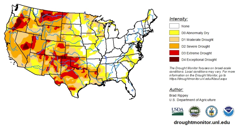
To view the Contiguous U.S. Drought Map, click here.
Looking ahead to Jan. 26 through 30, the only major storm system to affect the country will develop near the southern Atlantic Coast and move northward. Most of the remainder of the country will receive little or no precipitation, although exceptions during the next couple of days will include rain from southern Texas to Florida's peninsula and snow squalls downwind of the Great Lakes.
The 6-to-10-day outlook calls for the likelihood of above-normal temperatures in the eastern U.S., while colder-than-normal conditions will prevail along and west of a line from central Texas to Lake Michigan. Meanwhile, below-normal precipitation in the West, including northern and central California and the Great Basin, should contrast with wetter-than-normal weather in most areas from the central and southern Rockies to the Atlantic Coast.
To view the 6 - 10 Day Precipitation Outlook, click here.
To view the 6 - 10 Day Temperature Outlook, click here.
According to the Monthly Drought Outlook map, drought conditions should continue to improve from the Pacific Northwest, down into northern California and eastward to western Wyoming, Montana and northern Utah. Drought conditions are also expected to release California's southern coast and southern Arizona and a small part of southern New Mexico. In the rest of the West and Great Plains, drought conditions are expected to persist and further develop - especially in Texas.
To view the Monthly Drought Outlook map, click here.
Oklahoma
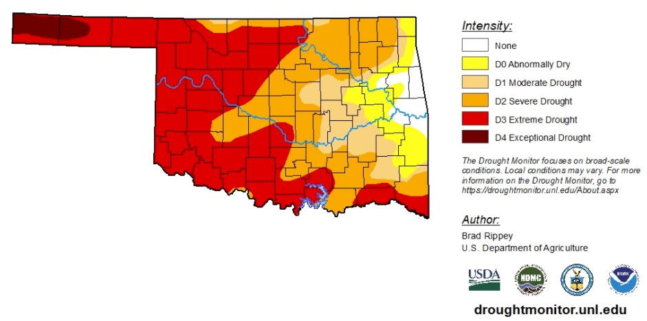
With data ranging between Jan. 18 to 25, drought conditions continue to degrade. Last week drought conditions exceptional drought was recorded in the state for the first time since the spring of 2018. The exceptional conditions have developed in the Panhandle, in Texas and Cimarron Counties and account for nearly 3% of drought conditions in the state. The Panhandle has faced abnormally dry conditions or worse since June 2021. According to the Mesonet, the Panhandle has received less than 3 inches of rain in the last four months. According to the first Oklahoma Crop Progress and Condition report of the year, winter wheat condition is 16% good to excellent, 41% fair and 43% poor to very poor.
Right now, 96% of the state is experiencing abnormally dry conditions or worse. Moderate drought conditions have decreased as overall drought conditions deteriorate, affecting just 10% of the state. Severe drought conditions affect 28% of the state. Extreme drought conditions have increased from 44% to 46% and dominate the western half of Oklahoma.
A small pocket of eastern Oklahoma continues to fight off abnormally dry conditions or worse.
The 6-to-10-day precipitation outlook map shows Oklahoma is likely to receive above-normal precipitation levels for this time of year. The 6-to-10-day temperature outlook map shows lower-than-normal temperatures are likely for most of the state.
To view the Oklahoma drought map, click here.
WebReadyTM Powered by WireReady® NSI
Top Agricultural News
More Headlines...

