

Agricultural News
Exceptional Drought Expanded to cover more of the Oklahoma and Texas panhandles
Thu, 10 Mar 2022 19:39:59 CST
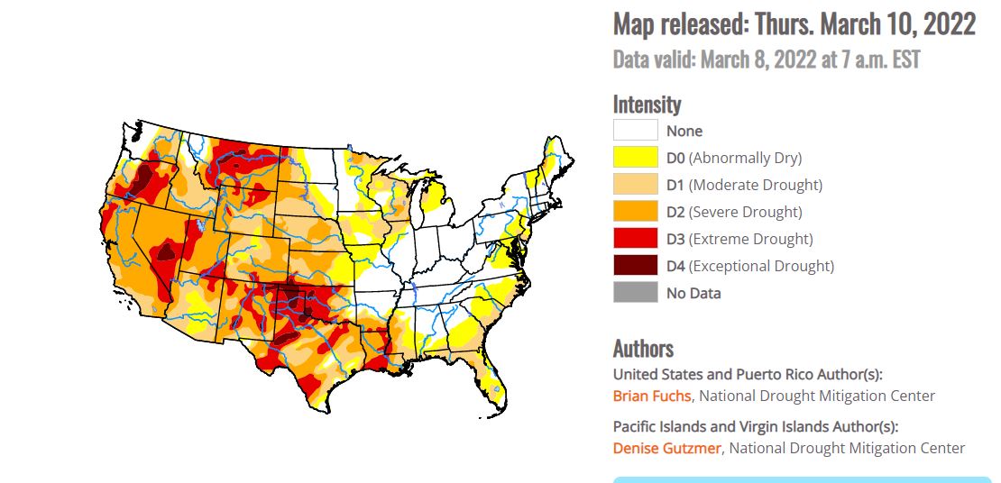
 Several storm systems from the northern Rocky Mountains to the Midwest brought with them rain, snow, and even some severe weather this past week. Temperatures for the week were cooler than normal over the northern Plains and into the West. The coldest readings were in the northern Plains and upper Midwest, with departures of up to 9 degrees below normal. Temperatures were warmer than normal over much of the eastern U.S., with the greatest departures (12-15 degrees above normal) over Tennessee and Kentucky. Areas of the Midwest, central Plains and into the West did see above-normal precipitation this week with areas of Kentucky, Indiana, and Ohio receiving over 2 inches of precipitation during the period. The southern Plains and South continue to dry out. As spring approaches and dormancy is broken, impacts are already showing in these areas and drought intensification is widespread with quickly expanding extreme and exceptional drought areas.
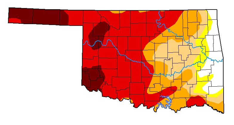
Temperatures were warmer than normal over most of the region, with departures of 9-12 degrees above normal over Tennessee. Areas of northern Oklahoma and Arkansas experienced the only precipitation events in the region with above-normal amounts as most all of the region was quite dry. Degradation continued with drought status over the region. As dormancy breaks and green-up begins, water demand has increased along with warmer temperatures. Exceptional drought was expanded to cover more of the Oklahoma and Texas panhandles. Severe drought was expanded over western Oklahoma along with a new pocket of exceptional drought. A full category worsening of drought conditions took place over west Texas and much of central and east Texas as severe and extreme drought expanded. Mississippi and Louisiana also had widespread degradation with extreme drought expanded over most of southern Louisiana and along the Mississippi River into Mississippi. Moderate and severe drought were also expanded over much of central Mississippi and into southeast Louisiana. The overall pattern from the southern Plains into the South has been dry and warm conditions that will only lead to worsening conditions as spring arrives. The 4-month period from November to February was the 2nd driest such period for Louisiana since 1895 with less than 10 inches of observed precipitation statewide. With some good rains in Louisiana after the data cutoff for consideration this week, there may be some opportunities for improvements next week where the greatest rains occur.
Today's Fire Situation Report shows several Red Flag Warnings A Red Flag Warning is in effect today for Cimarron and Texas Counties from Noon through 6:00 PM. In the warned area, 13% of normal rainfall has been received in the last 120 days and the area is currently +147 days separated from a wetting precipitation event. Winter precipitation chances increase in the area and more widespread winter precipitation chances overspread Oklahoma Thursday night into Friday.
Looking Ahead
Over the next 5-7 days, it is anticipated that cooler than normal temperatures will dominate the country, with departures of 9-12 degrees below normal over the Rocky Mountains and 3-6 degrees below normal over the Southeast. It is anticipated that the greatest precipitation will take place over the East coast, with local maximum amounts over southern Georgia and north Florida. Most areas are expected to record precipitation, with the northern Plains and California anticipated to be the driest.
The 6-10 day outlooks show that the likelihood of above-normal temperatures is greatest over the eastern half of the U.S., with the best chances over the Mid-Atlantic into the Northeast. Above-normal chances of below-normal temperatures are expected over Alaska. The best chances of above-normal precipitation are over the Pacific Northwest, Rocky Mountains and eastern U.S. Above-normal chances of below-normal precipitation are anticipated in the Southwest and northern Plains.
For Oklahoma:
Following a chilly start, temperatures will begin to warm into the 50º's across Oklahoma this afternoon. Temperatures today remain a bit below normal although low dew point temperature will open the door for afternoon relative humidity values dropping below 30% briefly this afternoon in most locations. Winds will be strongest in the Oklahoma Panhandle ahead of a cold front overnight. Elsewhere, dry conditions today will promote moderate fire danger conditions for a brief period this afternoon although new fie activity in the main body of the state is not expected to present undue suppression challenge outside of limited engine access in many areas resulting from rains on Sunday.
• Warned Area: Cold temperatures this morning will warm into the 55-59º range this afternoon in Cimarron and Texas Counties with relative humidity values falling into the 14-16% range. Fine-dead fuel moisture values will likely hover around 5% through most of the burning period given the presence of some sky cover although 4% observations are possible if skies clear during the peak of the afternoon burning period. Light winds this morning will increase into the afternoon with southwest winds sustained 20-25 mph gusting at times over 30 mph. Rangeland fuels in this area will likely exhibit head fire rates of spread 174-238 ft/min during peak burning conditions with flame lengths around 13 ft. Fire danger will moderate quickly after sunset with diving temperature and improving moisture.
Near-Term: Rain and snow chances Thursday across northern Oklahoma and then over much of Oklahoma Thursday night into Friday will prompt another downturn in fire danger. Amount and location of precipitation will be critical as a warming trend this weekend ushers in some stronger fire weather focused on western Oklahoma. The current near-term outlooks point to above normal temperatures and below normal precipitation following this round of wintry weather and climatological peak of fire occurrence in Oklahoma.
To view the U.S. Drought map, click here.
In Oklahoma, it has been more than a year since we have seen a map this void of drought shades.
To view the Oklahoma drought map, click here.
To view the 6-10-day temperature outlook, click here.
To view the 6-10-day precipitation outlook, click here.
To view the new seasonal drought outlook map, click here.
The U.S. Drought Monitor Map is developed through a partnership between the National Drought Mitigation Center at the University of Nebraska-Lincoln, the United States Department of Agriculture, and the National Oceanic and Atmospheric Administration.
WebReadyTM Powered by WireReady® NSI
Top Agricultural News
More Headlines...


