

Agricultural News
Drought Continues Across Oklahoma and Texas With Severe Weather in the Forecast
Thu, 17 Mar 2022 13:31:49 CDT
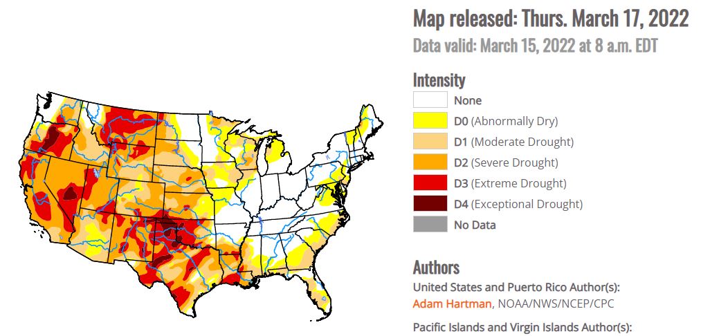
 According to the latest drought monitor report, High pressure dominated across much of the central U.S. this week, bringing much below-normal temperatures (more than 10°F below-normal) to the Eastern Rockies, Great Plains, and parts of the Mississippi Valley. Much of the north-central U.S. remained below freezing last week. However, where daytime high temperatures did average above the freezing mark, below-normal precipitation and high winds resulted in some drought degradation across parts of the Great Plains. A series of low pressure systems moving across the southern and eastern U.S throughout this week brought heavy rainfall to parts of the Gulf Coast states and Eastern Seaboard, leading to drought improvements. Northern Florida received the greatest rainfall amounts, with several areas picking up anywhere from 5 to 10 inches of rain through Saturday. The strongest of these storm systems also brought snowfall to the Appalachians and interior areas of the Mid-Atlantic and Northeast Friday into Saturday. In the Pacific Northwest, a series of storms brought some drought improvements to parts of the central Cascades and interior northern Rockies. Farther south across California, drought intensified this week due to mounting deficits since the beginning of the year.
Oklahoma
A series of low pressure systems, tracking across the Gulf Coast states throughout this week, resulted in heavy rainfall across parts of eastern Texas and the Lower Mississippi Valley, leading to broad 1-category improvements where the heaviest rains fell. Some parts of central Louisiana and west-central Mississippi received more than 5 inches of rainfall. Despite year-to-date rainfall deficits being reduced to near zero for several locations and USGS average stream flow running near-normal, soil moisture still ranks between the 5th and 10th percentile of the climatological distribution. This indicates that drought is still firmly entrenched across the Lower Mississippi Valley and that more rainfall will be needed to continue to see meaningful improvements. Farther west across central Texas and parts of Oklahoma, drought continued to intensify. Conversely, high winds and below-normal precipitation prevailed across central Texas and western Oklahoma this week, leading to continued drought degradation. Fire risk remains a concern across many of these areasAcco.
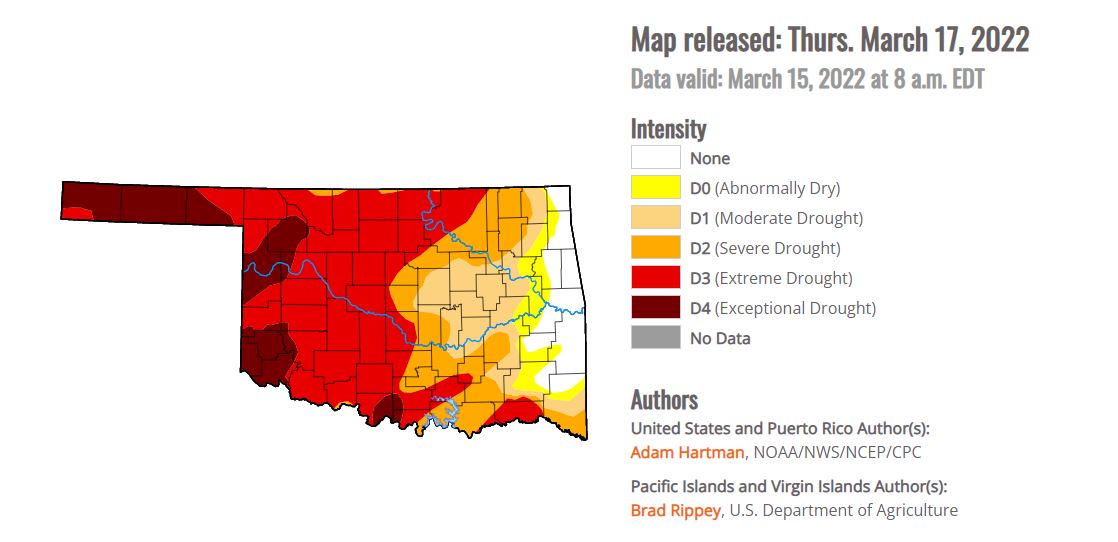
According to U.S. Drought Monitor, as of March 8, 2022, an estimated 3,371,714 Oklahomans
were experiencing drought conditions, with 12.03% of the state in area in Exceptional Drought (D4), the
worst category, 56.52% of the state in Extreme Drought (D3-4) or worse, 74.46% in Severe Drought (D2)
or worse, and 86.62% in Moderate Drought (D1) or worse.
To view the Oklahoma drought map, click here.
In the High Plains:
Although the High Plains region experienced widespread much below-normal temperatures this week (10°F to 15°F below-normal; even exceeding 15°F below-normal in the High Plains and Eastern Rockies), several areas saw continued deterioration of drought conditions. This was particularly true across parts eastern Nebraska and central Kansas, where high winds and below-normal 7-day precipitation only exacerbated ongoing short-term dryness brought about by a very dry winter season. Several of these areas have received only 5 to 20 percent of normal precipitation over the past 120 days and the fire risk has rapidly increased as a result. Shallow soil moisture is ranking below the 5th percentile of the climatological distribution, according to NASA SPoRT, and average stream flows are continuing to decline. Parts of southeastern Colorado, which is experiencing short to long-term drought, also experienced degradation this week from severe (D2) to extreme (D3) drought, supported by Keetch-Byram Drought Indices and short-term precipitation deficits (25 to 50 percent of normal precipitation over the past 90 days). Parts of northwestern Wyoming also experienced deteriorating drought conditions, due to depleted groundwater and year-to-date precipitation deficits that are now on the order of 5 to 10 inches. Conversely, there were targeted improvements across central Wyoming and northern Colorado, based on where positive weekly precipitation anomalies were observed, precipitation amounts are above-normal for the water year (since October 1, 2021), and NASA SPoRT soil moisture and USGS 7-day average stream flows are near and above-normal locally.
To view more information on drought, water resources and lake status, click here for the OWRB page.
For this weekend fire danger will be a problem with Windy forecasts on the agenda. A pesky low pressure system will move into Texas today, bringing an opportunity for severe storms across the Plains and the Gulf Coast.
A low pressure system from the Rockies will be moving into the Central Plains this afternoon. This system combined with strong upper level energy and a warm, moist air mass as well as a sharp dryline will lead to the potential for severe storms this evening and into the overnight hours. The main threats will be gusty winds exceeding 60 mph as well as the potential for large hail with a diameter greater than an inch. A few isolated tornadoes cannot be ruled out as well.
Residents in Oklahoma City as well as Plano and Garland, Texas, and Baton Rouge and New Orleans, La., will need to monitor current weather trends for the chance for severe thunderstorms as the Storm Prediction Center has issued a Slight Risk for these areas. Dallas and Arlington, Texas and Mobile, Ala., will also need to be weather aware as well.
To view the 6 - 10 Day Precipitation Outlook, click here.
To view the 6 - 10 Day Temperature Outlook, click here.
To view the Monthly Drought Outlook map, click here.
WebReadyTM Powered by WireReady® NSI
Top Agricultural News
More Headlines...


