

Agricultural News
State-Wide Rains have Helped Lesson Drought Conditions Across the State
Thu, 24 Mar 2022 10:57:31 CDT
 Several storm systems moved across the lower 48 states this past week. Heavy rain fell across parts of the Great Plains and Southeast, with lighter amounts observed across parts of the Pacific Northwest and Intermountain West. The Central and Southern Plains, Lower Mississippi Valley, and Southeast mostly saw improvements to drought conditions, with several locations receiving more than 2 inches of rainfall (more than 5 inches, locally) during the 7 days leading up to March 22. Throughout much of the U.S., where antecedent dryness coincided with below-normal precipitation, drought either continued or worsened in intensity. The only areas where this was not true was across parts of the Upper Midwest, which experienced some removal of long-term drought due to improvements from melting snow cover.
Two storm systems brought heavy rainfall across much of the Southern Region this past week. The first system dropped heavy rain across parts of central Louisiana and much of Mississippi before moving eastward very early in the period (March 15-16). The second storm system intensified over the Southern and Central Plains in the final day leading up to March 22, dropping heavy rain across central and eastern Oklahoma and northern and eastern Texas, extending eastward to the Mississippi River. Rainfall totals across many of these areas exceeded 2 inches, leading to large swaths of 1-category improvements in the drought depiction. 2-category improvements were also warranted in isolated locations receiving, in some cases, more than 5 inches of rain. Given the short-term nature of the drought, soil moisture indicators and stream flows responded quickly, leading to more aggressive improvements in eastern Oklahoma, eastern Texas, and the Ark-La-Tex. Farther west and south in Texas, many locations missed out entirely, receiving little to no precipitation this past week. This increased rainfall deficits that go back several months, resulting in the continued deterioration of drought across these areas.
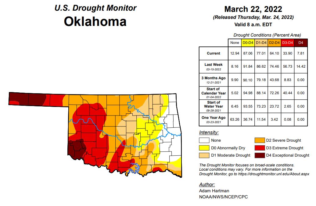
The nice rains that fell across the state earlier in the week has lessened the deep drought throughout Oklahoma. Right now 7.81% of the state is experiencing Exceptional Drought, which is better than last weeks number at 14.42%. 33.90% of the state is in Extreme drought which has lessened from 56.73% last week. 64.10% of the state is in Severe Drought down from 74.46% last week, and 77% of the state is still in the Moderate Drought range, down from 86.62% last week. 87% of the state is in the abnormally dry category and 12.94% is drought free.
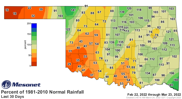
The last 30 days have improved as far as moisture goes for some, and that shows up pretty well on the maps. Keep in mind that last storm was responsible for almost all of these better looking numbers. To see the Change in drought numbers click here
To see the Last 30 day rainfall totals click here:
One Year ago there was No Exceptional drought throughout the state and only .08% in the extreme drought category.
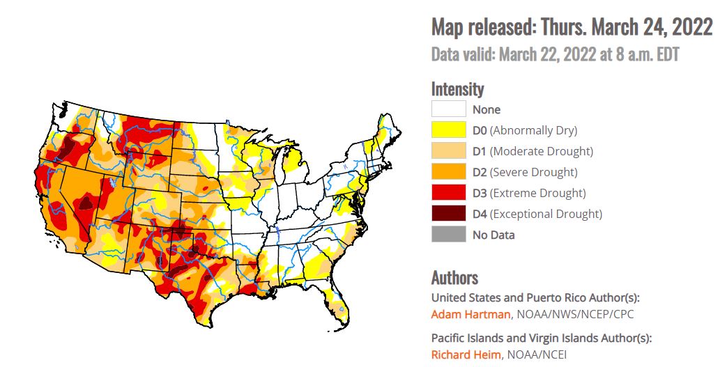
To see the Oklahoma Drought Monitor Click here:
For the next 10 in Oklahoma we will see mostly sunny skies, windy with warmer temperatures before the next cold front moves through. Next Tuesday and Wednesday showers and cooler temperatures are in the forecast.
Looking Ahead:
A storm system that brought heavy rainfall to eastern parts of the lower 48 states March 22-23 will continue to move northeastward and into the Great Lakes by Thursday, March 24. This storm will continue to bring the potential for rainfall across parts of the Southeast and Mid-Atlantic and mixed precipitation types across the Northeast and Great Lakes through Friday, March 25. By March 26, another fast-moving low pressure system is expected to sweep in behind the Great Lakes system to help push it out to sea by the weekend. Following the passage of these storm systems, colder air is likely across northeastern and north-central parts of the U.S., starting on March 26, with maximum temperature anomalies expected to be anywhere from 10°F to 20°F below-normal across parts of the Midwest. These cold temperatures will shift eastward toward the Northeast and Mid-Atlantic through March 29. Across the western U.S. high pressure is expected to dominate, favoring below-normal precipitation and above-normal temperatures through Monday, March 28. Maximum temperatures are predicted to be on the order of 15°F to 20°F above-normal, and greater, with the warmer temperatures shifting from the West Coast to the Great Plains and into the Southeast March 24-29, before beginning to moderate. On March 29, another storm system is predicted to move into the West Coast bringing an opportunity for much needed precipitation across portions of California.
The Climate Prediction Center's 6-10 day outlook (valid March 29 to April 2, 2022) favors near to above-normal temperatures across much of the western and eastern contiguous U.S. (CONUS) and the Gulf Coast. Below-normal temperatures are favored for the north-central and northeastern CONUS, behind strong low pressure exiting the East Coast near the start of the period. Above-normal precipitation is favored for much of the eastern two-thirds of the CONUS, as a storm system is expected to intensify and move eastward across U.S. during the period. Behind this storm system and farther to its south, below-normal precipitation is likely across parts of the western CONUS and southern Texas, respectively.
To view the 6 - 10 Day Precipitation Outlook, click here.
To view the 6 - 10 Day Temperature Outlook, click here.
To view the Monthly Drought Outlook map, click here.
WebReadyTM Powered by WireReady® NSI
Top Agricultural News
More Headlines...

