

Agricultural News
Drought Conditions Hold Steady as High Winds and Fire Danger Continue
Thu, 07 Apr 2022 09:10:47 CDT
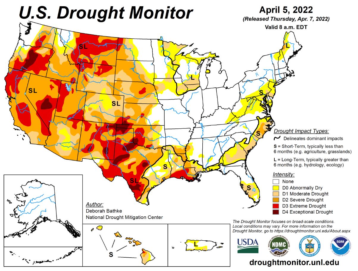
 According to the latest U.S. Drought Monitor report, April brought heavy rain to parts of the Midwest, South, and Southeast leading to broad areas of drought improvement in these regions. Meanwhile, drought expanded and intensified in the West with many locations setting records for the driest 3-month period (January to March). The High Plains remained largely unchanged this week with small pockets of improvements and degradations.
In the southern Plains, Like last week, the South saw drought worsen across west and south Texas and the Oklahoma Panhandle. Above-normal temperatures combined with below-normal precipitation and high winds exacerbated conditions. Drought indicators supporting the degradations include increasing precipitation deficits, dry surface and root zone soil moisture and low stream flow. One-category improvements were made to drought conditions across east Texas, southern Arkansas, north and central Louisiana and Mississippi as the effects of the recent wet pattern propagated through indicators such as streamflow, soil moisture, and vegetation. Note that the heavy, solid black line separating the part of the region experience short-term drought was modified to reflect the effects of the recent rain.
In the High Plains, South-central Colorado saw a reduction in severe (D2) and extreme (D3) drought. Last week's precipitation continued a trend of wetter-than-normal conditions that's been in place since the start of the year. Short- and long-term indicators including precipitation, snowpack, soil moisture, and stream flow are responding to the excess moisture. Severe drought also decreased in southwest Wyoming for similar reasons. Kansas saw drought worsen in the west and improve in the east. D3 expanded in southwest Kansas, where precipitation deficits are less than 10 percent of normal over the last 60 to 90 days. Other indicators supporting this assessment include increased evaporative demand and soil moisture. In eastern Kansas, the map depicts a continuation of improvements made last week. In south-central Nebraska, moderate drought expanded in response to increasing precipitation deficits, dry soil moisture indicators, and reports of low stock ponds. The rest of the region remained unchanged this week. State drought monitoring teams have all noted the increasing dryness across the region.
The West saw Another week of above-normal precipitation combined with below temperatures led to more improvements across the Midwest this week. Large areas of 1-category improvements took place across the Upper Midwest where rain and snow totals of 150% to more than 300% of normal fell over the last 30 days. Short-term deficits have been erased with long-term drought remaining in areas where precipitation deficits of 6 months or longer exist and where deeper soil moisture and groundwater indicators are slower to recover.
To view the Contiguous U.S. Drought Map, click here.
Looking ahead to April 7-9th, The National Weather Service Weather Prediction Center calls for another storm system to move across the eastern half of the Lower 48. Multi-day snow is expected over the long-term drought areas in the Upper Midwest. Drought areas in the Southeast and Mid-Atlantic are expected to see rain. Meanwhile, dry weather is expected across much of the drought-stricken Plains and West. An approaching front moving into the Pacific Northwest and Northern Rockies will bring rain and snow. Moving into the weekend, the forecast (valid April 9 13) calls for rain and high elevation snow and well below normal temperatures across the West. The colder temperatures, rain, and snow will reach into the northern and central Plains by early next week. At 8 14 days, the Climate Prediction Center Outlook (valid April 14 20) calls for below normal temperatures over much of the western and central U.S. and Alaska. Above normal temperatures are predicted over the east and west coasts. Near to above normal precipitation is favored for the Central Rockies eastward. Below normal precipitation is favored over California, Nevada, southeastern New Mexico, and southwestern Texas.
To view the 6 - 10 Day Precipitation Outlook, click here.
To view the 6 - 10 Day Temperature Outlook, click here.
To view the Monthly Drought Outlook map, click here.
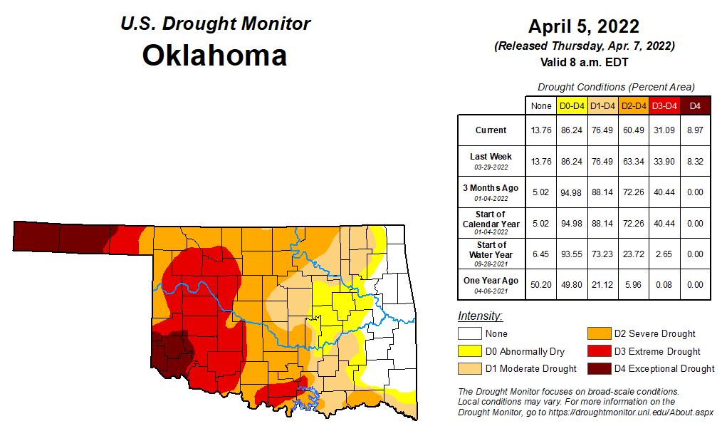
Oklahoma
In Oklahoma 2,919,800 people are affected by drought. Exceptional Drought is at 8.3% with Greer, Harmon, Jackson, Cimarron and Texas Counties in Exceptional Drought. (Last Week this number was at 8.32%).
33.9% of the state is in Extreme Drought this week, (same as last week) 63.3% is in Severe Drought, (Down from 64.1% a week ago) 76.5% in Moderate Drought,(down from 77% last week) and 86.2% (Down from 87.1% last week) of the state is abnormally Dry.
We currently have 28 counties with USDA Disaster Designations, and this is the 40th Driest year to date over the past 128 years. The drier air and the strong winds that front left behind are setting the scene for a possible wildfire outbreak of significant proportions across Oklahoma, especially in the far NW section of the state and eastern Panhandle where fire conditions are considered "extremely critical" by the SPC wildfire forecasts. A Red Flag Fire Warning for much of the state. The next chance of rain we will see comes early next week when a broad upper-level low pressure system moves into the West and gives us a chance of storms. There is the possibility of a pretty decent severe weather setup for early next week,
The 6-to-10-day precipitation outlook map shows Oklahoma is in for Sunny and Windy and warm conditions. Highs will range from the mid 60's to the upper 80s. There is a slight chance of Rain next Tuedsay.
To view the Oklahoma drought map, click here.
WebReadyTM Powered by WireReady® NSI
Top Agricultural News
More Headlines...

