

Agricultural News
Red Flag Warning is in Effect today As Fires Burn Across the State
Wed, 13 Apr 2022 08:28:47 CDT
 A Red Flag Warning is in effect today from 11:00 AM through 10:00 PM today in the Oklahoma
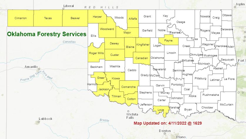
Panhandle and from Noon through 7:00 PM in southwestern Oklahoma. A cold front continues to work through Oklahoma this morning with some precipitation chances increasing south of I-44 and maybe a few early sprinkles northwest. Much cooler temperatures expected today in the post-frontal environment although poor overnight moisture recovery and continued strong winds will hold fire danger concern in the western half or so of Oklahoma today with focus on the Warned Areas. As dry conditions persist across the west, fire danger will remain in place for some time with composite fuel moisture in critical status over the rangelands. Fortunately, winds are expected to relax overnight and improved overnight moisture recovery (still not great though) will provide for a shorter burn period today.
Today: Red Flag warnings are again in place in the Panhandle and southwestern counties. Intensity of the fire weather inputs are not quite as strong as yesterday when most fires were quickly contained before becoming established. Post-frontal dryness in the western half of Oklahoma will result in an increase in fire danger concern across a broader area, although many areas in central Oklahoma have barriers to fire spread with some herbaceous green-up along roadsides and grazed pastures, especially south of I-40.
• Oklahoma Panhandle: A Red Flag Warning has been issued noting that potential for a stalled frontal boundary may limit meeting warning criteria. Nonetheless, critically dry fuels remain fully available with composite fuel moisture nearing record low values and fine-dead fuel moisture at 3-4% this afternoon. Cooler, post-frontal temperatures at 53°-56° today along with relative humidity values 10-16% under partly-cloudy skies are forecasted for today. Somewhat calmer northerly winds this morning will become northwest sustained 17-22 with gusts around 30 mph. Rangeland fuels will support head fire rates of spread 134-202 ft/min with flame lengths 12-16 ft.
• Southwestern Oklahoma: 64°-74° this afternoon with relative humidity values below 20% under mostly-clear skies with fine-dead fuel moisture at 4% will encourage active fire behavior on established fires. Northwest winds sustained 17-23 with gusts around 35 mph over dry, grass-dominated fuels will produce head fire rates of spread at 153-219 ft/min with flame lengths11-15 ft. Winds will become calm overnight providing good opportunity for initial attack success.
• Western/North-Central Oklahoma: Afternoon relative humidity values will fall below 25% across most of the area in the post-frontal environment. Cooler temperatures today especially north at 60°-74° under clearing skies coupled with low relative humidity values will yield fine-dead fuel moisture values at 5% across much of the area with 4% observations west. Northwest winds will be strongest this morning relaxing a bit into the afternoon sustained around 15 mph with some higher gusts. Grass-dominated fuels will exhibit head fire rates of spread 120-173 ft/min with flame lengths 10-13 ft. Winds will relax overnight providing expectation for successful initial attack. Resources Available: (800) 800-2481
• OFS Suppression Group (Overhead, Engines, Dozers) Woodward
• Oklahoma National Guard Blackhawk - Woodward
• OFS Suppression Group (Overhead, Engines, Dozers) Assigned to Berlin Rd. Fire
• Oklahoma National Guard Blackhawk - Weatherford
• 1 OHP Fixed-Wing Aircraft w/ OFS Operations Specialist
Near-Term: Current Quantitative Precipitation Forecast holds no optimism for rains in western Oklahoma while temperatures hover close to normal. Looking out a bit further, the 6-10 Day Outlooks suggest a lean to below-normal temperatures holding below-normal precipitation chances in place.
Burn Bans:
Refer to: https://ag.ok.gov/divisions/forestry-services/ for the most current burn ban
NE Area
EC Area No New Activity
SE Area
Large / Significant Fire Activity within the OFS Protection Area:
• East Fork Glover Fire (McCurtain County)- 220 Acres / 100% Contained
• Crystal Cave Fire (Cherokee County) 1,000 Acres (est.) / 100% Contained
• Tram Road Fire (Pushmataha County) 163 Acres / 100% Contained
Fire Activity with OFS Response outside of the Protection Area:
• Berlin Road Fire (Roger Mills County) 8,000 acres (est.) / 15% Contained
OFS Prescribed Fire Activity: No New Activity
WebReadyTM Powered by WireReady® NSI
Top Agricultural News
More Headlines...


