

Agricultural News
Drought in Central and Eastern Oklahoma Improves Significantly while Drought in the Western Half of the State Holds Steady
Thu, 19 May 2022 10:29:53 CDT
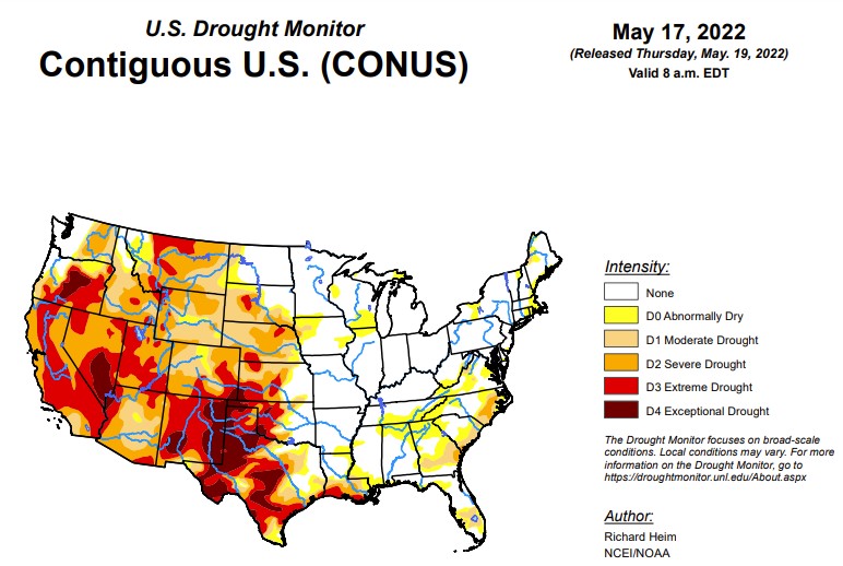
 According to the latest U.S. Drought Monitor report, in the upper levels of the atmosphere, a strong ridge of high pressure dominated the contiguous U.S. (CONUS), from the southern Plains to Northeast, at the beginning of this U.S. Drought Monitor (USDM) week, while an upper-level trough dominated the West. The trough moved east as the week progressed, dragging a surface low pressure system and cold fronts across the northern Plains to Great Lakes, while another upper-level low moved over the Southeast and weakened. Weekly temperatures averaged much warmer than normal beneath the ridge and cooler than normal in the West beneath the trough. The fronts, lows, and upper-level troughs brought above-normal precipitation to parts of the Pacific Northwest, northern Plains to western Great Lakes, and spotty areas in the South, New England, and along the Atlantic Coast. The week was drier than normal across the rest of the CONUS. The continued lack of precipitation further dried soils, lowered stream levels, and stressed crops and other vegetation, while the excessively warm temperatures increased evapotranspiration and added to the stress. Drought or abnormal dryness contracted where precipitation was above normal, especially in the Northwest, northern Plains, and Mid-Atlantic. Drought or abnormal dryness expanded or intensified where it continued dry, especially in the Southwest, southern to central Plains, Southeast, and parts of the Northeast.
In the Southern Plains, all of the states in the South region had areas of rain with amounts of half an inch or more, but large areas also received no rain. Temperatures were persistently hot throughout the week, increasing evapotranspiration, further drying soils, and stressing crops and vegetation. On May 15, Abilene, Texas recorded 8 days in May with 100-degree-F temperatures. This set a new record for the highest number of days in May with 100 degree temperatures. The previous highest number of days for Abilene was 7 days, set in 2000 and in 1927. Recent dryness is compounding long-term dryness, especially in western parts of the region. By some measures, Culberson County in Texas had the driest September-April on record and second driest December-April, and that is not counting the dryness so far in May. Corpus Christi, Texas recorded the third driest February-May to date out of 136 years of record. According to USDA statistics, 86% of the topsoil moisture in Texas was short or very short, and 53% was short or very short in Oklahoma and Louisiana; 74% of the pasture and rangeland was in poor or very poor condition in Texas; and 81% of the winter wheat in Texas and 52% in Oklahoma was in poor or very poor condition. Drought or abnormal dryness contracted in the few areas in Texas and Oklahoma where more than an inch of rain fell on Dx areas. But abnormal dryness and moderate to exceptional drought expanded in many more areas of Texas. Abnormal dryness and moderate to extreme drought expanded in southwest Louisiana, and abnormal dryness grew in Tennessee.
In the High Plains, northern and eastern parts of the High Plains were wet this week while western and southern parts were dry. Two inches to locally over 4 inches of precipitation fell over parts of North Dakota and eastern Montana, and half an inch or more was widespread over the Dakotas, northern Wyoming, and eastern parts of Nebraska and Kansas. But most of Colorado received no precipitation this week and very little occurred over southern Wyoming and western parts of Nebraska and Kansas. Moderate to exceptional drought expanded in Colorado, extreme to exceptional drought expanded in Kansas, extreme drought expanded in Nebraska, and abnormal dryness expanded in western Montana. To the north, abnormal dryness and moderate to severe drought contracted in North Dakota, eastern Montana, and northern Wyoming. Severe to extreme drought expanded in Meade County, South Dakota, to reflect impacts and moisture conditions that included low or no surface water, very short pasture and range conditions, and general poor vegetation. The widespread D3 degradations through southeast Colorado and into the San Luis Valley were a result of very dry and windy conditions over the last few months. According to USDA statistics, in Colorado, 52% of the pasture and rangeland and 45% of the winter wheat were in poor to very poor condition, and 41% of winter wheat in Kansas was in poor or very poor condition, with the statistics 77% for pasture and rangeland in Montana, 49% for pasture and rangeland in Wyoming, 44% for pasture and rangeland in South Dakota, and 41% for pasture and rangeland in Nebraska. The USDA statistics show 60% of Colorado's topsoil short or very short of moisture, 73% for Montana, 58% for Wyoming, 51% for Kansas, and 37% for Nebraska.
In the West, pacific weather systems brought 2 or more inches of precipitation to the coastal ranges and windward portions of the Cascades in Oregon and Washington, with half an inch or more from northeast Oregon to northern Idaho and in eastern Montana. Less than half an inch fell in other parts of the Pacific Northwest and northern Rockies. Little to no precipitation occurred across the southern states in the West region, from California to New Mexico. Weekly temperatures averaged cooler than normal except in the Four Corners states. The hot temperatures in New Mexico continued to increase evapotranspiration and dry soils. The Calf Canyon/Hermits Peak fire exceeded 298,000 acres burned, becoming the largest wildfire in modern New Mexico history. Moderate to exceptional drought expanded in New Mexico; extreme drought expanded in Utah; moderate to extreme drought expanded in Arizona; and exceptional drought from Nevada crept southward into northwest Arizona. Further north, extreme drought was removed from Washington, while abnormal dryness and moderate to exceptional drought contracted in Oregon. The precipitation of recent months in the Pacific Northwest has helped refill some reservoirs, especially the smaller ones. But larger ones remain depleted, including Oregon's Crescent Lake reservoir, which is 12% full, Prineville (32%), Phillips (13%), Warm Springs (18%), Owyhee (46%), Howard Prairie (16%), Emigrant (26%), and Hyatt (20%). According to USDA statistics, 89% of the topsoil moisture was short or very short in New Mexico, 47% in Utah, and 40% in Nevada, and 51% of the pasture and rangeland was in poor or very poor condition in New Mexico.
To view the Contiguous U.S. Drought Map, Click Here.
Looking ahead, the upper-level circulation will continue to bring Pacific weather systems across the CONUS during the next USDM week. Temperatures are forecast to be below normal from the Pacific Northwest to Great Lakes and southward into the central Plains. An eastern ridge will keep temperatures warmer than normal along the East Coast. An inch or more of precipitation is predicted to fall through Tuesday morning for some of the mountains of the Pacific Northwest and central to northern Rockies. An inch or more is expected from the southern Plains to Great Lakes and eastward to the East Coast, but some areas along the East Coast will have less than an inch and some areas from the Lower Mississippi Valley to Ohio Valley, as well as much of Florida, can expect 2 or more inches. Most of the Great Plains will see less than half of an inch of rain. Much of the Southwest, from California to New Mexico and including parts of the Pacific Northwest, will receive little to no precipitation. For the period May 24-28, odds favor above-normal temperatures for the Southwest, Deep South, East Coast, and southwest Alaska, and below-normal temperatures in Washington, the Upper Mississippi Valley, and eastern Alaska. Odds favor below-normal precipitation from California to the western portions of the central and southern Plains, as well as western Alaska, while above-normal precipitation is likely in Washington, east-central Alaska, eastern portions of the southern Plains, and from the Mississippi Valley to East Coast.
To view the 6 - 10 Day Precipitation Outlook map, click here.
To view the 6 - 10 Day Temperature Outlook map, click here.
To view the Monthly Drought Outlook map, click here.
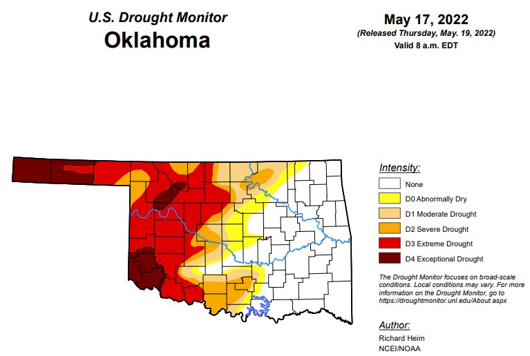
Oklahoma:
In Oklahoma, 1,038,915 people are affected by drought. Exceptional drought is 10.5% (last week was 10.4% and last month was 8.9%) with Cimarron, Texas, Greer, Jackson, and Harmon counties almost completely affected by exceptional drought. Beaver, Woods, Major, Woodward, Ellis, Dewey, Beckham, Kiowa, and Tillman counties are affected to some degree by exceptional drought. 35.9% of the state is in extreme drought this week, which is down from last week at 39.4%. 44.9% of the state is in severe drought this week (last week this number was 55.3%). Down significantly from last week is moderate drought at 53.5%, down more than 10 points from last week's 65.3%. Abnormally dry or worse dropped from last week's 77.2% to this week's 60.3%.
We currently have 66 counties with USDA disaster designations, and this is the 36th driest year to date over the past 128 years.
Friday, Oklahoma will see a pretty strong cold front that should drop temperatures into the 60s and 70s for highs and 40s and 50s for lows. For those in the western panhandle, lows could possibly reach the 30s. Next week should be somewhat cooler before returning to summer heat.
The seasonal precipitation outook map shows a low chance of moisture from June to August. With the possibility of a cooler fall through early spring coming up, rain will be critical during this time.
To view the Oklahoma drought map, click here.
WebReadyTM Powered by WireReady® NSI
Top Agricultural News
More Headlines...


