

Agricultural News
Drought Monitor Shows Drought in Oklahoma With a Sginificant Decline
Fri, 27 May 2022 05:13:15 CDT
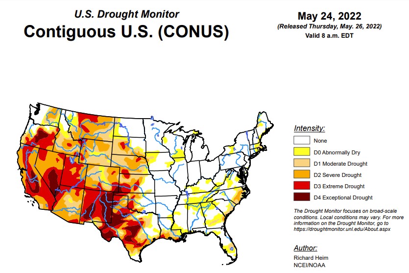
 According to the latest U.S. Drought Monitor report, a strong upper-level trough moved across the contiguous U.S. (CONUS) during this U.S. Drought Monitor (USDM) week (May 18-24). Surface low pressure systems and cold fronts were associated with this complex trough. They tapped Gulf of Mexico moisture to spread above-normal precipitation across parts of the Plains, Midwest, Southeast, and Mid-Atlantic Coast, and locally heavy snow across parts of Colorado. One of the fronts moved very slowly across the southern Plains near the end of the week, dumping locally heavy rain on parts of Oklahoma and Texas. Precipitation also fell across parts of the Pacific Northwest, North Dakota, and western Great Lakes. Most of the West was drier than normal, with much of the area from Oregon to California and southern Idaho to New Mexico receiving little to no precipitation. Weekly temperatures averaged below normal behind the fronts from the Pacific Northwest to Great Lakes and from the northern Rockies to Mid-Mississippi Valley. Temperatures averaged warmer than normal across the eastern third of the CONUS and from California to Texas. The continued lack of precipitation in the dry areas further dried soils, lowered stream levels, and stressed crops and other vegetation, while the warmer-than-normal temperatures increased evapotranspiration that added to the stress caused by lack of precipitation. But widespread heavy rain fell across several drought areas, contracting drought and abnormal dryness, especially in the central to southern Plains, Lower Mississippi Valley, Southeast, and Mid-Atlantic states. Drought and abnormal dryness also shrank in the Pacific Northwest where drought indicators showed improving conditions. Drought or abnormal dryness expanded or intensified where it continued dry, especially in southern parts of the West, in the Ohio and Tennessee Valleys, and parts of southern New England.
In the Southern Plains, a large part of Oklahoma and parts of Texas and Louisiana were inundated with several inches of rain, over 6 inches in places. Zapata County in southern Texas received about half a year of normal rainfall this week. Heavy rain in central and northern Oklahoma, and in the Texas panhandle, southern Texas, and southeast Texas, resulted in the contraction of abnormal dryness and moderate to exceptional drought. Abnormal dryness contracted in Arkansas, D0 and D1 contracted in Mississippi, and D0-D3 shrank in Louisiana. Other parts of the South region were dry. D2-D4 expanded in parts of central to northeast Texas, D0 expanded in Mississippi and Tennessee, and a spot of moderate drought was added in eastern Tennessee.
In the High Plains, two inches or more of precipitation fell across southern and eastern parts of Kansas, central Colorado, and northeast Nebraska, while half an inch or more was widespread across North Dakota. Parts of Nebraska, northeast Colorado, Wyoming, South Dakota, and eastern Montana received less than half an inch of precipitation. In Colorado, moderate to extreme drought contracted where it was wet, while severe and extreme drought expanded where it was dry. Abnormal dryness and moderate to extreme drought shrank in parts of Kansas. The rain ate a hole into severe drought in northeast Nebraska. Abnormal dryness and moderate drought were trimmed in western North Dakota. On the other hand, it was a dry week in western Wyoming with D3 expanding in Teton County.
In the West, half of an inch or more of precipitation fell in the Coastal and Cascade ranges of the Pacific Northwest, and northern to central Rockies. But more southerly parts of the West, from southern Oregon to New Mexico, received no precipitation. Abnormal dryness to severe drought were trimmed in Washington, Oregon, Idaho, and Montana. Extreme drought shrank in southwest Montana, while exceptional drought was trimmed in Oregon. Some of the drought contraction was due to drought indicators showing slightly less severe conditions. In the drier areas of the West, D3-D4 expanded in New Mexico, D2-D3 expanded in Arizona, D3 spread in Utah and adjoining parts of Idaho and Wyoming, and D2 expanded in southern California with slight expansion of D4 from adjoining southern Nevada. Arms of exceptional drought were added to the San Joaquin Valley in California where the National Weather Service noted that dry conditions continue throughout the area; snow cover is virtually non-existent below 8,000 feet; peak flow through area rivers and inflow into the reservoirs has already occurred or will occur soon, weeks ahead of normal; and applications for grants for well drilling, purchasing tanks, and bottled water recipients are increasing. In southern California, the Coastal Fire broke out on May 11th in Orange County near Laguna Niguel. Windy conditions spread it rapidly upcanyon where it burned 200 acres, destroyed 20 homes, and damaged 12 others. Near-record dry fuels around the May 11th time frame set the stage for this fire.
To view the Contiguous U.S. Drought Map, Click Here.
Looking ahead, a strong upper-level low pressure system slowly moved across the Plains during May 24 and 25, spreading heavy rain over the southern and central Plains to Lower and Mid-Mississippi Valley. This weather system, with its surface low and fronts, will move slowly eastward during the next several days. Another upper-level low pressure system will move from the Pacific Ocean into the western CONUS by Sunday. In addition to the 1+ inches of rain that has already fallen across the Plains to Mississippi Valley May 24-25, another 1 to 2 inches is expected from the Mississippi Valley to Appalachians and northward to the Great Lakes through May 31. An inch or more of precipitation is forecast for the Pacific Northwest to northern Plains and parts of the Interior Basin in association with the western weather system. Little to no precipitation is expected through May 31 for southern states in the West, and no additional precipitation is forecast for Texas and western portions of the southern High Plains. Warmer-than-normal temperatures are forecast for May 26-31 for the central to southern Plains ahead of the western weather system, while clouds and rain will keep high temperatures near to cooler than normal in the West and East. For May 31-June 4, odds favor above-normal precipitation in the Pacific Northwest, Great Plains, Southeast, and most of Alaska, but below-normal precipitation for the Midwest to Northeast and California to southern Nevada. Warmer-than-normal temperatures are likely for May 31-June 4 across most of Alaska and the eastern half of the CONUS, while odds favor cooler-than-normal temperatures from the Great Basin to northern Plains.
To view the 6 - 10 Day Precipitation Outlook map, click here.
To view the 6 - 10 Day Temperature Outlook map, click here.
To view the Monthly Drought Outlook map, click here.
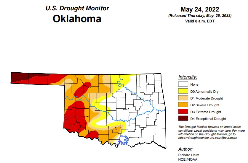
In Oklahoma:
In Oklahoma, 532,057 people are affected by drought. Exceptional drought is 2.9% (last week was 10.5% and last month was 9.4% ) with Cimarron and Texas Counties still having a mix of exceptional and extreme drought.
Extreme drought or worse is at 18.25%, down from last week's 35.9% and last month's 36%.
Severe drought or worse in Oklahoma this week is 35.97%, down from 44.86% last week
Moderate drought or worse is 43.6%- down about 10 percentage points from last week.
Abnormally dry or worse conditions improved this week to 53% compared to last week's 60.3%.
To view the Oklahoma drought map, click here.
WebReadyTM Powered by WireReady® NSI
Top Agricultural News
More Headlines...

