

Agricultural News
Oklahoma Finally Sees Significant Decline in Drought Conditions
Thu, 09 Jun 2022 10:07:32 CDT
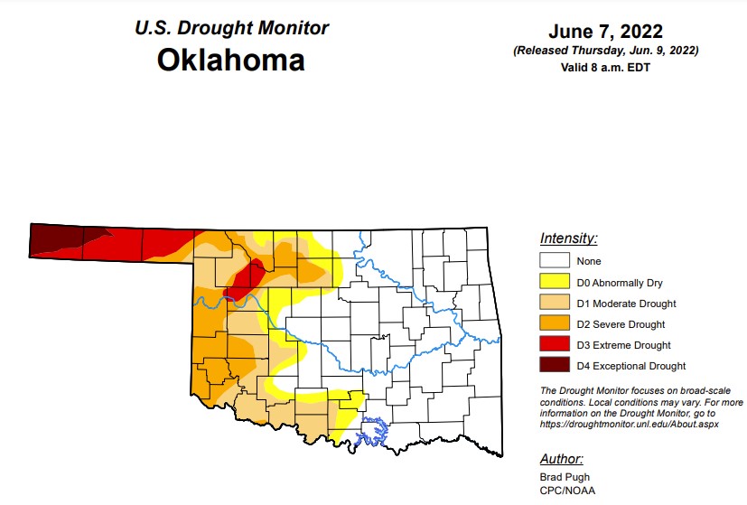 According to the latest drought monitor, in Oklahoma, exceptional drought is 2.47 percent, compared to last week's 2.93 percent. Currently, Cimarron and Texas counties are the only two counties in the state facing levels of exceptional drought.
Extreme drought or worse dropped 8 percentage points from last week and is now at 8.8 percent (last week was 17.16 percent).
Severe drought or worse is at 21.3 percent, down 13.5 points from last week's 34.8 percent.
Moderate drought or worse is at 35.3 percent, down from last week's 42.5 percent.
Abnormally dry or worse conditions are at 43.1 percent, down from 48.9 percent last week.
The 6-10-day precipitation outlook map shows the majority of Oklahoma has a below-normal chance of rain through June 18.
To view the Oklahoma drought map, click here.
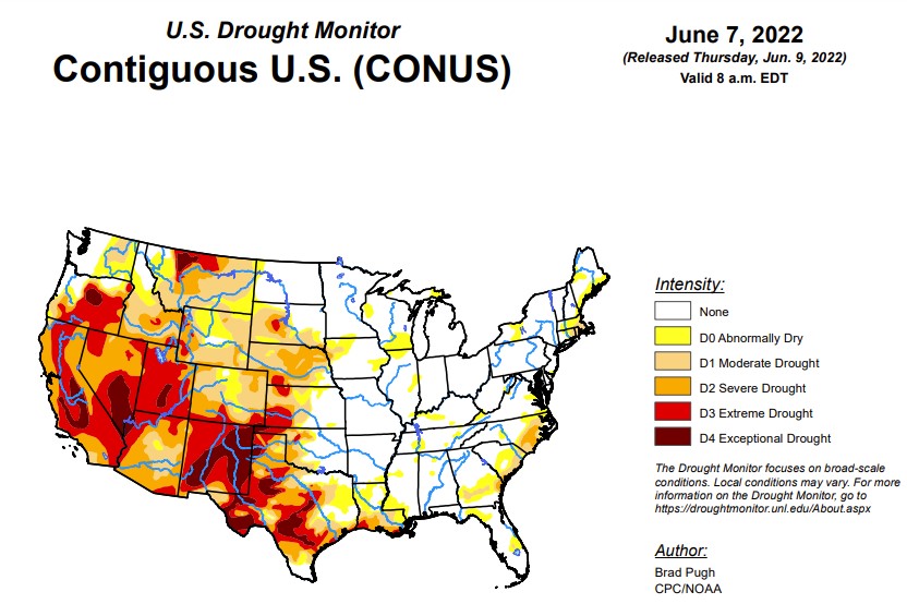
According to the latest U.S. Drought Monitor Report, a slow-moving cold front resulted in thunderstorms with heavy rainfall (locally more than 3 inches) across the central to southern Great Plains, lower Mississippi Valley, and the Ozarks Region from May 31 to June 2. As this front progressed eastward, locally heavy rain also fell across the Ohio Valley and Northeast. Mid-level low pressure, which has persisted over the northeastern Pacific through much of the spring, continued to enhance onshore flow and precipitation from the Pacific Northwest eastward to the northern Rockies. 7-day precipitation amounts from May 31 to June 6 exceeded 0.5 inches (locally 2 inches or more) over a broad spatial area of Oregon, Washington, Idaho, Montana, and northern Wyoming. After Hurricane Agatha made landfall on the southern coast of Mexico, its remnant low pressure system tracked northeast to the Yucatan Peninsula and reemerged over the southern Gulf of Mexico. This low pressure system, which became Tropical Storm Alex, brought more than 5 inches of rainfall to southern Florida and triggered flooding in Miami. Seasonal dryness prevailed across southern California and the Desert Southwest. 7-day temperatures, from May 31 to June 6, averaged above-normal across much of the eastern and southern tier of the U.S., while cooler-than-normal temperatures prevailed throughout the northern to central Great Plains and upper Mississippi Valley.
In the Southern Plains, heavy rainfall (1.5 to 3 inches, locally more) resulted in a 1-category improvement to west-central OK and northwestern TX, setting up a tight west to east gradient in Dx categories. In areas such as Custer County in western Oklahoma, that locally received as much as 8 inches of rainfall during the past week, a 2-category improvement was justified. This heavy rainfall extended southward into southeastern New Mexico and western Texas where parts of the Permian Basin, Davis Mountains, and Big Bend received more than 2 inches at the beginning of June. Farther to the east across parts of central and eastern Texas, along with northwestern Louisiana, increasing short-term precipitation deficits (2 to 4 inches), above-normal temperatures, and higher evapotranspiration rates resulted in a 1-category degradation. This expansion of abnormal dryness (D0) was supported by 30 to 60-day SPEI and these areas stand out on the EDDI product for flash drought. Eastern Texas and northern Louisiana will have to be closely monitored in subsequent weeks as short-term drought could rapidly develop. Locally heavy rain (more than 1 inch) this past week resulted in a slight decrease in D0 for northeastern Louisiana. On June 6, heavy rainfall extended south of the Ohio River which led to a general decrease in the small areas of D0 in Tennessee.
In the High Plains, heavy rainfall (1.5 to 3 inches, locally more) this past week resulted in a 1-category improvement to southeastern and central Kansas. More than 1.5 inches of rainfall this past week, along with soil moisture and long-term SPIs, supported a change from exceptional (D4) to extreme (D3) drought in parts of southwestern Kansas and adjacent southeastern Colorado. Widespread beneficial rainfall, exceeding 1 inch, this past week prompted a 1-class improvement to much of eastern Colorado. Swaths of heavy rainfall (more than 1 inch) also led to improvements of various Dx categories across parts of Nebraska and South Dakota. Much above-normal precipitation during the past 30 to 90 days and soil moisture percentiles supported the elimination of moderate drought (D1) across much of west-central Wyoming.
In the West, the wet late spring continues to support improving conditions from the Pacific Northwest eastward to the Northern Rockies. Based on multiple indicators including springtime precipitation, soil moisture, and streamflow, a broad 1-class improvement was made to eastern Washington with improving conditions also supported for parts of Oregon. The recent precipitation was enough to shift the long-term SPEIs out of exceptional (D4) drought in much of Klamath and Lake Counties of Oregon. In western Idaho, severe drought (D2) was improved to moderate drought (D1) based in part on the hydrologic response in the Weiser Basin. Southwestern Montana had a 1-class improvement, following recent wetness, soil moisture recharge, and 60-day SPI. Precipitation amounts of 1 to 3 inches along with below-average temperatures resulted in a 1-category improvement to parts of north-central Montana. Despite the recent cool pattern, 90 to 180-day SPIs supported 1-category degradation to parts of northern Montana. Impacts in this worsening drought area include required supplemental feeding, very dry soils, and dry stock ponds. Based on 90-day SPI and hydrology considerations in the Sevier River basin, extreme (D3) to exceptional (D4) drought was expanded across parts of Utah. Widespread severe to exceptional drought persists throughout much of the Southwest, Great Basin, and California. Hydropower production concerns at reservoirs in California and Nevada continue due to low water levels.
To view the Contiguous U.S. drought map, click here.
Looking ahead, A couple of low pressure systems and trailing cold fronts are forecast to bring widespread, heavy rainfall to the Northeast and Mid-Atlantic through June 11. Along a nearly stationary front, a swath of heavy rainfall is forecast to spread southeastward from the Ozarks Region to the northern Gulf Coast on June 9 and 10. The wet pattern is likely to continue from the Pacific Northwest eastward to the northern Rockies and northern Great Plains through June 13, as another low pressure system emerges from the northeastern Pacific. Meanwhile, a heat wave is forecast to expand from California and the Desert Southwest eastward to the south-central U.S. during mid-June.
The Climate Prediction Center's 6-10 day outlook (valid June 14-18, 2022) depicts large probabilities (more than 70 percent) for above-normal temperatures across the southern Great Plains, lower Mississippi Valley, and Southeast. Below-normal temperatures are favored to persist across the Pacific Northwest. Below-normal precipitation is favored for the central to southern Great Plains, middle to lower Mississippi Valley, and much of the Corn Belt. Probabilities for above-normal precipitation are elevated across the Pacific Northwest along with parts of the Southwest.
To view the 6 - 10 Day Precipitation Outlook map, click here.
To view the 6 - 10 Day Temperature Outlook map, click here.
To view the Monthly Drought Outlook map, click here.
WebReadyTM Powered by WireReady® NSI
Top Agricultural News
More Headlines...


