

Agricultural News
End to Exceptional Drought in Oklahoma is Near, Down to 1.4 Percent
Thu, 16 Jun 2022 09:57:55 CDT
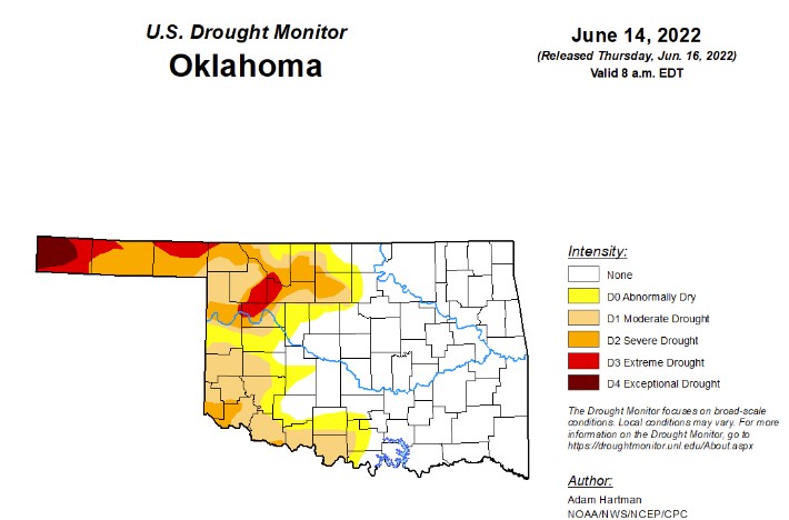 According to the latest drought monitor, in Oklahoma, exceptional drought is at 1.4 percent this week, which is half of last week's number of 2.4 percent. Currently, Cimarron County is the only county in the state facing any levels of exceptional drought.
Extreme drought or worse dropped 3 percentage points from last week and is now at 5.4 percent (last week was 8.8 percent).
Severe drought or worse is at 15.8 percent, down almost 6 percentage points from last week's 21.3 percent.
Moderate drought or worse is at 30.3 percent, down from last week's 35.3 percent.
Abnormally dry or worse is also down from last week at 40.3 percent (last week was 43.1 percent).
The 6 to 10 day precipitation outlook map shows an above-average chance of rain for the Oklahoma panhandle, and a lower chance of rain as you go further east. In the next two weeks, Oklahoma will be experiencing above-average temperatures.
To view the Oklahoma drought map, click here.
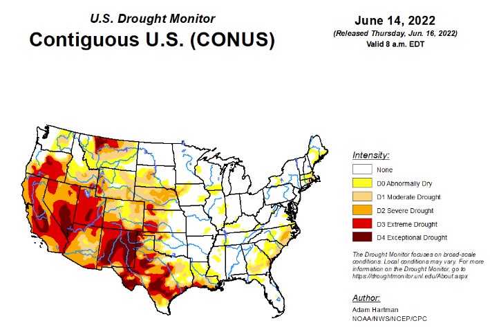
According to the U.S. Drought Monitor Report, the storm track remained active across much of the contiguous U.S. (CONUS) this week. Much of the Northern Tier states experienced beneficial rainfall and near to below-normal temperatures, predominantly leading to drought improvements from the Pacific Northwest to the Northern Plains. Storm systems and clusters of thunderstorms also resulted in some improvements from the Mississippi Valley to the East Coast. However, where the heaviest rains did not fall, there was some deterioration and slight expansion of abnormal dryness or drought conditions, particularly in parts of the Southeast and Ohio and Tennessee Valleys. Above-normal temperatures and below-normal precipitation was the main story across much of the southwestern CONUS, extending into Texas, leading to general persistence and degradation of drought conditions. Weak trade winds in Hawaii and below-normal precipitation in Alaska have continued, resulting in degradations this week. Warm and dry conditions also contributed to worsening conditions in Puerto Rico.
In the Southern Plains, short-term (30 to 60-day) rainfall deficits continue to mount across parts of the Lower Mississippi and Tennessee Valleys. Coverage of D0 (abnormal dryness) was generally expanded, although coverage is sporadic. Seasonal temperatures in these areas helped keep evapotranspiration rates at bay this week. However, daily soil moisture anomalies continue to become more negative, particularly over the past couple of weeks from northern Louisiana, extending northeastward toward the Tennessee Valley, as several locations have seen continued declines in surface moisture. Similar to the Carolinas, these areas will need to be watched in the coming weeks, as potentially excessive heat and below-normal precipitation is forecast through the end of the month. Drought deterioration is also warranted across much of Texas, which saw another week of much above-normal temperatures, high winds, and below-normal precipitation. Some of these degradations extended into western Louisiana also. However, in eastern Louisiana, a cluster of thunderstorms provided some relief to abnormally dry (D0) and moderate drought (D1) areas. Improvements are also warranted in western Oklahoma, particularly in areas that received at least 1 inch rainfall surpluses this week. Some 2-category improvements occurred in areas where year-to-date precipitation deficits declined and daily soil moisture estimates improved to near-normal down to 200 cm.
In the High Plains, much of the High Plains Region has seen beneficial rainfall and temperatures averaging near to below-normal over the past 30 days. However, above-normal temperatures finally crept in this week, as temperatures ran more than 3°F above-normal for much of the region. Despite the above-normal temperatures, precipitation was also above-average for many locations, warranting broad 1-category improvements in the drought depiction where more than 1 inch 7-day surpluses were observed and where longer-term deficits were appreciably diminished. Only areas in southwestern Colorado and just east of the Front Range in Wyoming experienced some degradation, as temperature anomalies were highest in those areas (6°F to 9°F above-normal). Also, high winds have helped to exacerbate ongoing drought in those locations.
In the West, much of the Northern Tier of the U.S. from the Pacific Northwest to the Northern Plains, has seen marked improvements in recents months due to a persistent storm track and near to below-normal temperatures. That same pattern continued this week and continued to eat away at long-term precipitation deficits and indicators, such as groundwater. Additionally, some high-elevation locations have even picked up additional snowpack and stream flows are running near to much above-normal over the past 28 days. Given the wet conditions in recent months and the continuation of the active storm track, broad improvements are warranted again this week. The only exception is parts of north-central Montana, where precipitation has generally missed many areas near the Golden Triangle in recent months, warranting some slight degradation this week, as precipitation again missed these areas. Elsewhere in the Western Region, despite the much above-normal temperatures, a general status quo depiction was warranted, the exception being Nevada and New Mexico. A slight expansion of extreme drought (D3) was warranted in central Nevada, where 7 to 28-day average stream flows are running below the 5th percentile of the historical distribution, vegetation indices are indicating similar signals as D3 areas to the east, and KBDIs are indicating high soil moisture deficiency in the upper layers. Despite some nearby monsoon precipitation in parts of New Mexico and Arizona, accumulations were not enough to change the severe (D2) to exceptional (D4) drought depictions in areas where the rains fell. Given the temperatures were running anywhere from 5°F to 10°F above-average, and coupled with windy conditions, additional degradations were made in parts of western and southern New Mexico. Additionally, CPC soil moisture continues to remain below the 5th percentile much of the region and nearby stream flows are averaging in the bottom 2 percent of the historical distribution.
To view the Contiguous U.S. Drought Map, click here.
A storm system with a trailing frontal boundary will exit the northeastern contiguous U.S. (CONUS) over the next 2 days (June 16-17), bringing below-normal temperatures and chances for precipitation to parts of the Great Lakes and Northeast. High pressure is forecast to build over the central CONUS and spread eastward through Tuesday, June 21. Maximum temperatures across parts of the north-central CONUS may reach 15°F to 20°F above-normal. The northwestern CONUS is expected to remain active, as another storm system is forecast to push onshore into the Pacific Northwest and into the Intermountain West during the weekend and leading up to the Tuesday cutoff. With it will come increased chances for precipitation in areas that experienced improvements in recent weeks. Below-normal temperatures are also forecast across much of the western third of the CONUS, in the wake of this passing system.
The Climate Prediction Center's 6-10 day outlook (valid June 21-25, 2022) favors above-normal temperatures and near to below-normal precipitation across the eastern CONUS. Below-normal temperatures and below-normal precipitation are favored across the Pacific Northwest and northern Great Basin, in the wake of a passing storm system near the start of the 6-10 day period. However, there is a weak tilt in the odds toward above-normal precipitation in northern Washington. A surge of moisture is expected to bring increased chances of precipitation to the Four Corners region, signaling a potential early start to the Southwest Monsoon season, with probabilities of above-normal precipitation extending northeastward into portions of the Central and Northern Plains. Near to below-normal precipitation and above-normal temperatures are favored over much of California.
To view the 6 - 10 Day Precipitation Outlook map, click here.
To view the 6 - 10 Day Temperature Outlook map, click here.
To view the Monthly Drought Outlook map, click here.
WebReadyTM Powered by WireReady® NSI
Top Agricultural News
More Headlines...

