

Agricultural News
While Oklahoma Sees Minuscule Drought Improvement, Far Southeast and Northeast Corners Abnormally Dry Again
Thu, 30 Jun 2022 12:53:24 CDT
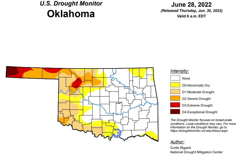 According to the latest drought monitor, in Oklahoma, exceptional drought is the same as the past two weeks at 1.4 percent with Cimarron County being the only county in the state facing levels of exceptional drought as they wait for some moisture.
Extreme or worse this week is 5.07 percent down a hair from last week's 5.45 percent.
Severe drought or worse is at 14.79 percent, down one percentage point from last week's 15.8 percent.
Moderate drought or worse this week is at 30.7 percent, down from last week's 31.2 percent.
Abnormally dry or worse conditions worsened in the far northeast and southeast corners of the state. This week's abnormally dry conditions are at 45.9 percent, compared to last week's 41 percent.
The 6-10 precipitation outlook map shows the majority of Oklahoma is leaning below a 40 percent chance of rain, with the panhandle showing a near-normal chance of rain. The majority of the state can expect temperature highs in the 90s and 100s for the next 6-10 days.
To view the Oklahoma Drought Map, click here.
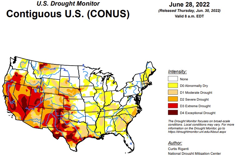
According to the latest U.S. Drought Monitor Report, widespread moderate drought and abnormal dryness continued to form and expand across a large swath of the eastern U.S. this week, with a few areas of severe drought forming or expanding as well. Spotty rain and storms occurred across the East, but in areas that missed out on heavy rainfall, high temperatures, browning lawns, and curling corn signaled that rapid drying was taking place in many areas. An early start to the North American Monsoon, particularly in New Mexico and southern Colorado, led to widespread improvement of extreme and exceptional drought in those states. Extreme drought formed or expanded in parts of the central Great Plains this week, where warm, dry weather continued. Moderate short-term drought also began to expand in parts of New England this week. Short-term moderate and severe drought expanded in coverage in Alaska and Puerto Rico, and drought conditions continued to expand in parts of Hawaii. Finally, despite some improvements to conditions in parts of the West, severe, extreme, and some exceptional drought remains widespread there.
In the Southern Plains, mainly dry conditions prevailed in the South this week, particularly from central Oklahoma and northeast Texas through Arkansas. Elsewhere, conditions were mostly dry, though some areas of heavier precipitation fell locally. Precipitation deficits improved enough in parts of western Oklahoma and the Texas Panhandle for some limited improvements to long-term drought conditions. Elsewhere, conditions mostly stayed the same or degraded, and abnormal dryness and moderate short-term drought quickly became entrenched in parts of east Texas, northern Louisiana, northern Arkansas, northern Mississippi, and Tennessee. Severe and extreme short- and long-term drought continued to plague southern Louisiana and a large portion of Texas this week. In drought areas in Texas, soil moisture deficits and low streamflow remained a major impact this week. There, extreme heat made drought-related problems worse. White-tailed deer are expected to have lower antler quality this fall in Texas due to the conditions. Additionally, crop stress continued and stock tanks lowered.
In the High Plains, extreme drought developed in far northeast Nebraska, and in adjacent portions of South Dakota and Iowa, near the Sioux City area. Here, on the short- and long-term precipitation deficits have combined with high evaporation rates to create significant soil moisture and groundwater shortages, which have recently been reported. Severe and extreme drought also expanded across northeast and central Colorado, southeast Wyoming, and parts of southwest Nebraska, where dry weather continued. North Platte, Nebraska may tie its second driest June on record, with 0.43 inches of rain having accumulated so far as of the morning of June 29. In southern Colorado, an early and active North American Monsoon has delivered heavy enough rainfall to cut into short- and long-term deficits, leading to widespread improvement of drought conditions in the southwestern part of the state. After recent heavy rains, drought conditions have continued to improve in northwest Wyoming. Heavy rain in central and south-central Kansas alleviated precipitation deficits and increased soil moisture and streamflow, such that drought conditions retreated to the west.
In the West, improvements to drought conditions in the West continued this week, though much of the region remains entrenched in drought or abnormal dryness. After recent heavy precipitation, and cool temperatures during April-June, drought conditions continued to improve in Montana and adjacent northeast Idaho this week. Due to heavy precipitation associated with the early and active start to the North American Monsoon, most of New Mexico, and parts of southeast Arizona, saw improvements to ongoing drought conditions. Despite these improvements, drought, still ranging from severe to exceptional in many areas, continued in the West, leading to cricket and grasshopper swarms.
To view the Contiguous U.S. Drought Map, click here.
Looking ahead, Through the evening of Monday, July 4, the National Weather Service Weather Prediction Center is forecasting dry weather across roughly the western two-thirds of Texas, much of Oklahoma, and most of the Intermountain West. Some precipitation is forecast across parts of Colorado and the Lower Missouri River Valley. Along the Gulf Coast, widespread precipitation is forecast to occur, with the heaviest amounts centered over parts of the Texas coast, where a tropical disturbance will approach. Heavy rainfall is also possible in coastal portions of Georgia and South Carolina. Elsewhere, pockets of moderate to heavy precipitation may fall across parts of the Southeast, mainly in the southern Appalachians or closer to the coasts.
For the period from Wednesday, July 6 to Saturday, July 9, the National Weather Service Climate Prediction Center forecast favors above-normal precipitation across much of the Upper Midwest, northern Great Plains, and Ohio River Valley. Below-normal precipitation is favored in much of Texas and Oklahoma, and across most of the West, with the highest probabilities for below-normal precipitation occurring across northeast Nevada, northern Utah, southern Idaho, and western Wyoming. A large area of high probabilities for warmer than normal temperatures exists across the central U.S., especially from the Great Plains to the Missouri and Mississippi River valleys. Above-normal temperatures are also favored in parts of the West and Southeast.
To view the 6 - 10 Day Precipitation Outlook map, click here.
To view the 6 - 10 Day Temperature Outlook map, click here.
To view the Monthly Drought Outlook map, click here.
WebReadyTM Powered by WireReady® NSI
Top Agricultural News
More Headlines...


