

Agricultural News
Abnormally Dry Conditions in Oklahoma Jump 18 Percentage Points Since Last Week
Thu, 07 Jul 2022 09:24:12 CDT
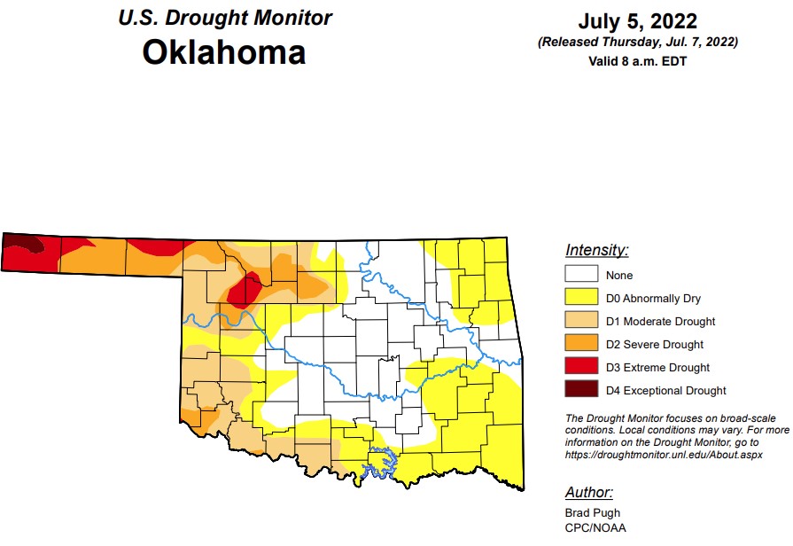 According to the latest drought monitor, in Oklahoma, exceptional has finally dropped below one percent and is at .6 percent. Last week's exceptional drought levels were at 1.4 percent.
Extreme drought or worse this week is unchanged from last week at 5.07 percent.
Severe drought or worse is same as last week at 14.7 percent.
Moderate drought or worse has increased slightly from last week and is at 31.1 percent (last week was 30.7 percent).
Abnormally dry or worse conditions have made a jump from last week's 45.9 percent and are now at 64.3 percent.
The 6-10 day precipitation outlook map shows Oklahoma is leaning above a 33-40 percent chance of rain through July 16. Temperatures 5-10 degrees above normal can be expected for the next week.
To view the Oklahoma Drought Map, click here.
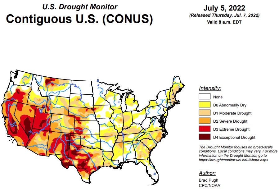
According to the latest U.S. Drought Monitor report, short-term drought continued to rapidly expand across the Ohio, Tennessee, and Middle Mississippi Valleys along with parts of the Corn Belt. Thunderstorms brought locally heavy rainfall and drought relief to parts of the central to northern Great Plains. However, 7-day temperatures averaged above-normal throughout the Great Plains. A tropical disturbance in the western Gulf of Mexico and a trough of low pressure resulted in heavy rainfall and improving drought conditions to southeast Texas and southwest Louisiana. Convective rainfall was highly variable this past week across the Southeast with isolated amounts exceeding 3 inches while other areas remained mostly dry with worsening drought conditions. New England experienced a week of mostly dry weather and expanding drought coverage. Following the unusually heavy Monsoon rainfall during late June, heavy amounts were more localized this past week across New Mexico. Seasonal dryness prevailed throughout California, while much of the Pacific Northwest became drier after a wet spring. Drier-than-normal conditions persisted for much of Alaska into the beginning of July. A tropical wave of low pressure tracked northwest from the central Atlantic and brought heavy rainfall to eastern Puerto Rico.
In the Southern Plains, the rapid onset of drought continues to affect parts of the Tennessee and Lower Mississippi Valley with a continued increase in coverage of short-term moderate drought (D1). Western Tennessee and northern Mississippi were especially dry the past two weeks with many areas receiving less than 0.25 inches of rainfall. This dryness was combined with above-normal temperatures. Therefore, severe drought (D2) was added to parts of northern Mississippi and western Tennessee. 30-day SPEI, EDDI, and soil moisture indicators were used as guidelines in these degradations. Likewise, D0-D1 was also expanded across northeast Texas, southeast Oklahoma, and Arkansas. The number of Arkansas counties, designated with burn bans, continues to increase. In the 6 week period since May 25, Jonesboro, Arkansas has recorded 1.17" of precipitation, or about 25% of normal. This is the driest such period since 1952. SPI values, starting at 120 days through the past 24 months, along with CPC's leaky bucket soil moisture (lowest percentile) supported an expansion of D4 across the Texas Panhandle.
Closer to the Gulf Coast, heavy rainfall (more than 1.5 inches) resulted in widespread 1-category improvements to southern Louisiana and southeastern Texas. In areas that received more than 5 inches of rainfall such as southwest Louisiana, a 2-category improvement was justified. A small 2-category improvement was also made to northeastern Texas that received 3 to 6 inches of rainfall. Recent, heavy rainfall also led to a trimming of the extension of moderate drought (D1) across central Mississippi.
In the High Plains, Locally heavy rainfall (more than 1 inch) this past week resulted in 1-category improvements to parts of Kansas, Nebraska, and South Dakota. Based on increasing short-term precipitation deficits and consistent with worsening soil moisture indicators, severe drought (D2) expanded across north-central Nebraska and extreme drought (D3) was added to more of northeastern Nebraska. Recent precipitation and reassessment of longer term SPI values supported a slight reduction of severe drought (D2) in southwestern Wyoming. Following a drier-than-normal June with above-normal temperatures (+3-4 degrees F), degradations were made to northeastern High Plains of Colorado. Recent monsoonal rainfall and the "convergence of evidence" of multiple indicators led to improvements for southern Colorado.
In the West, the North American Monsoon remained robust into the beginning of July, resulting in near to above normal precipitation across Arizona and New Mexico. Following the widespread 1-category improvement made the previous week throughout New Mexico, improvements were limited to areas of the heaviest rainfall. Additional improvements may be necessary in subsequent weeks depending on the Monsoon rainfall. Beneficial rainfall (more than 1 inch) continued to result in drought elimination across eastern Montana. Parts of north-central Montana have remained drier since the spring and extreme drought (D3) was expanded which was supported by soil moisture data. Drought coverage and intensity remained steady for the remainder of the West.
To view the Contiguous U.S. Drought Map, click here.
A major heat wave is forecast to affect much of the south-central U.S. through at least July 7 or 8 with the anomalous heat becoming centered across the Southern Great Plains and West by mid-July. A swath of heavy rainfall (1 to 3 inches, locally more) is forecast from the Middle Mississippi and Ohio Valleys southeastward to the Mid-Atlantic States from July 7 to 11. Mostly dry weather is expected for the Northeast, Gulf Coast States, Lower Mississippi Valley, and Southern Great Plains. Monsoonal rainfall is forecast to be lighter compared to late June.
The Climate Prediction Center's 6-10 day outlook (valid July 12-16, 2022) favors above-normal temperatures throughout the West, Great Plains, and Gulf Coast States. Below-normal temperatures are more likely for the Great Lakes and Midwest. Below-normal precipitation is favored for the northern Great Plains and Middle to Upper Mississippi Valley. Probabilities for above-normal precipitation are elevated across eastern Alaska, the Great Basin, Southwest, Southern Great Plains, and along the East Coast.
To view the 6 - 10 Day Precipitation Outlook map, click here.
To view the 6 - 10 Day Temperature Outlook map, click here.
To view the Monthly Drought Outlook map, click here.
WebReadyTM Powered by WireReady® NSI
Top Agricultural News
More Headlines...


