

Agricultural News
Chances of Precipitation Next Week as Oklahoma Drought Conditions Persist
Thu, 18 Aug 2022 09:59:27 CDT
 Today's report does not reflect some of the rains the state has received this week- those will show up in next week's report.
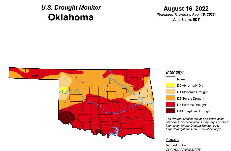
According to the latest drought monitor report, in Oklahoma, exceptional drought is now at 3.5 percent, up from last week’s .67 percent.
Extreme drought or worse has increased to 59 percent, up from last week’s 48.8 percent.
Severe drought or worse has decreased about 2 percentage points from last week and is now at 90.6 percent. (Last week as at 92.4 percent)
Moderate drought or worse is the same as last week at 99.3 percent.
Abnormally dry or worse has held steady for a few weeks now at 100 percent.
The 6-10-day precipitation outlook map shows the majority of the state is leaning above a 40-50 percent chance of precipitation, with the eastern part of the state a little higher, leaning above a 50-60 percent chance.
Oklahoma is forecast to receive 3-5 inches of precipitation over the next week. For September, the Oklahoma Mesonet predicts increased odds of above-normal temperatures across western Oklahoma, but the rest of the state is variable.
To view the Oklahoma drought map, click here.
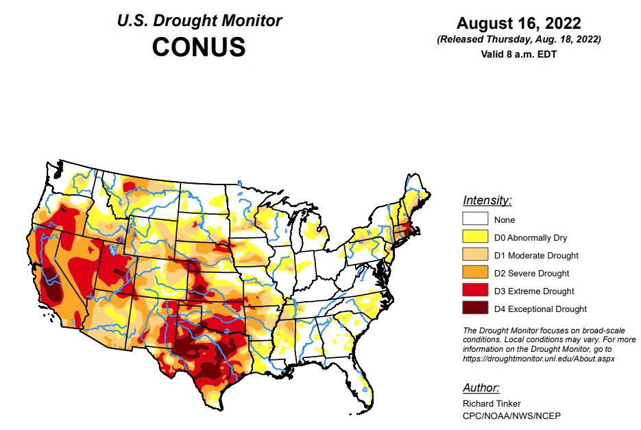
According to the latest U.S. Drought Monitor Report, precipitation again varied widely across the Lower 48 this week, which is not unusual during the summer. Across the interior West, monsoon rains were not as intense as last week, but remained heavier than normal. Several times the normal amount soaked most areas in the western half of the Four Corners Region, much of Nevada, southeastern California, reaching as far north as southeastern Oregon and Wyoming. Other areas receiving widespread heavy rains (and thus some improvement from recent dryness) included Deep South Texas and northwestern Nebraska. Parts of Deep South Texas recorded over 10 inches of rain, and 2 to 3 inches were common across northwestern Nebraska. Elsewhere, relatively narrow swaths of moderate to heavy rain dampened parts of the middle Mississippi Valley, Upper Midwest, and Great Lakes Region. Meanwhile, a broken pattern of moderate to heavy rain covered roughly the southeastern quarter of the contiguous 48 states. The higher amounts were in the 2 to 3 inch range though some small, highly-isolated areas recorded a bit more. In contrast, light precipitation at best fell on the Northeast, which teamed with abnormally high temperatures to induce significant and widespread intensification. Other areas observing light rain at best included part of the Upper Midwest, the north-central and south-central Plains. Conditions were seasonably dry along the West Coast.
In the Southern Plains, last week’s precipitation - though variable - followed the same general pattern as the precious week. Heavy rains drenched much of the eastern reaches of the Region while lesser amounts and localized deterioration were noted farther west. On significant exception was Deep South Texas, where heavy to intense rainfall brought significant improvement to areas of abnormal dryness and drought. Amounts exceeding 2 inches were widespread south of a line from Webb and LaSalle Counties eastward through San Patricio County, and amounts of 5 to locally over 10 inches drenched areas north of the Mexican border counties. This prompted nearly universal 1-category improvements on the Drought Monitor, with small areas of 2-category improvement where rainfall was heaviest. Extreme drought (D2) or worse are now confined to areas north and west of Duvall County. Elsewhere, increasing rainfall brought additional improvement to the Lower Mississippi Valley and Tennessee, but amounts were generally below-normal from central Texas northward through Oklahoma. Enough rain fell on central and northern Texas to keep areas of deterioration small, but little rain fell from the Red River (South) into northern Oklahoma, where larger areas of intensification were observed. Broad areas of exceptional drought (D4) still cover much of a large area from the southern Texas Panhandle southeastward toward the Gulf Coast. Over the last half-year, rainfall deficits of 8 inches to locally over a foot have affected areas of central Texas near and south of Dallas/Fr. Worth to the Gulf Coast.
In the High Plains, light rainfall at best fell on Kansas and farther north across the Dakotas. In contrast, heavy precipitation augmented by intrusions of monsoonal moisture covered large areas from Colorado and Wyoming eastward into western Nebraska. Dryness and drought eased in these areas, with improvement most widespread across the southern half of Wyoming and in the Colorado High Plains. Precipitation in these areas generally exceeded an inch, with 2 to 4 inches falling on several areas from southeastern Wyoming into northwestern Nebraska. Outside of the band of heavy precipitation that brought some improvement to Nebraska and adjacent areas, little or no rain fell on central and southern Kansas, and across most of the Dakotas, with South Dakota recording less rainfall than areas to the north. As a result, dryness persisted or intensified in these areas. Most of the Dakotas and the eastern tier of the Region measured near or below half of normal for the last 3o days, with several patches across the central Dakotas and southeastern Kansas receiving 25 percent of normal or less. In sharp contrast, most areas from central Wyoming through eastern Colorado and western Nebraska reported 150 to locally over 300 percent of normal since mid-July.
In the West, ample rains from the North American Monsoon continued through mid-August. Seven-day totals of 1 to 3 inches - with isolated higher amounts - fell across southwestern New Mexico and Arizona northward through much of the central and eastern Great Basin, and the western half of Utah. As a result, several large areas of improvement were noted this week, with the heaviest rains and most widespread improvement covering Arizona. After an extended period of serious drought, the heavy rains have prompted broadscale improvement in monsoon-affected areas. Two-category improvements over the past 4 weeks have occurred in areas recording the heaviest rainfall. Meanwhile, drought and dryness have been changing in the opposite direction across the northern tier. Most notably, abnormal dryness and moderate drought have been expanding across central and western Montana due to deficient precipitation and well above normal temperatures, while intensification has been slower and covers smaller areas in Idaho and Washington. Most of the Pacific Coast states have been dry and periodically hot as well, but this is their dry season, so totals are not far removed from normal.
To view the contiguous U.S. drought map, click here.
Looking ahead, the next five days could see heavy rainfall and improvement across a large part of northern Texas and southern Oklahoma eastward along the Arkansas/Louisiana border. Amounts of 2 to 3 inches are expected to be widespread here, with small areas south of the Texas Panhandle and in southeastern Oklahoma expecting over 4 inches of rain. Farther west, the robust monsoon looks to continue unabated. Between 2 and 4 inches are expected over southern sections of the Four Corners Region. But monsoon moisture is not expected to bring tropical moisture and heavy rainfall north of the central Rockies. Farther east, the rest of the southern tier of states are expected to get near or above an inch of rain, with bands of heavier rainfall expected in the Carolinas, southeastern Georgia and the central Gulf Coast. Much of the Upper Midwest and northern Ohio Valley should get several tenths to nearly 2 inches of rain, although the highest totals should be highly isolated. In stark contrast, little or no rain is expected over the contiguous states to the north and west of Kansas.
To view the 6-10-day precipitation outlook map, click here.
To view the 6-10-day temperature outlook map, click here.
To view the monthly drought outlook map, click here.
WebReadyTM Powered by WireReady® NSI
Top Agricultural News
More Headlines...


