

Agricultural News
Oklahoma Drought Decreases in All Categories After Recent Rainfall
Thu, 25 Aug 2022 09:46:24 CDT
 Recent rains have finally pushed percentages down slightly in drought categories, but more moisture will be needed to have a larger impact on the numbers. Analysis will continue through the next week for next week’s report. Oklahoma may be in luck, as it appears we will have a chance for some precipitation in the coming week, which will hopefully show more in next week’s drought monitor report.
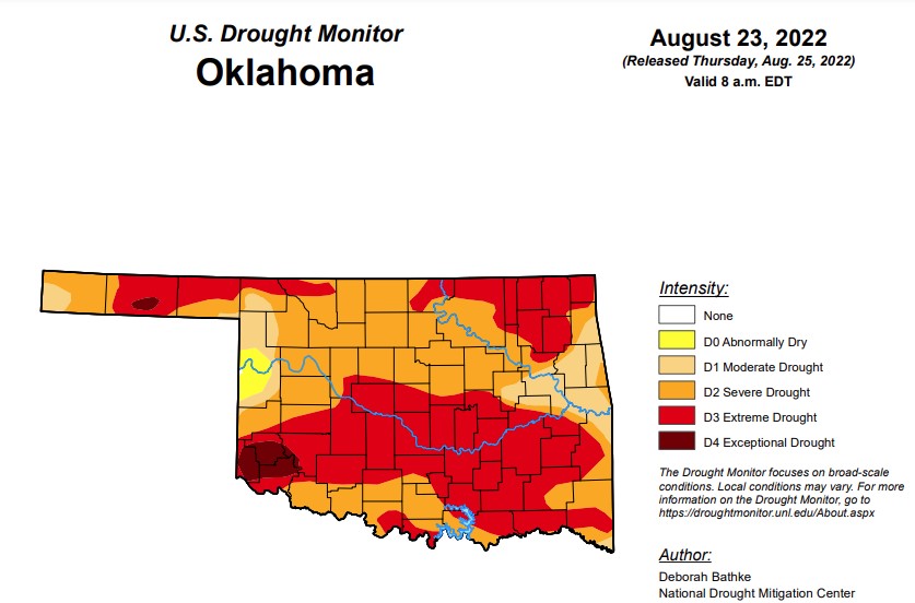
According to the latest drought monitor report, in Oklahoma, exceptional drought is now 2.19 percent, down from last weeks 3.5 percent
.
Extreme drought or worse has dropped down to 48.6 percent, down from last week’s 59.15 percent.
Severe drought or worse is now at 89.6 percent, down from 90.6 percent last week.
Moderate drought or worse is now at 98.6 percent, down from last week’s 99.3 percent.
After being at 100 percent for weeks, abnormally dry or worse conditions have dropped slightly, now, to 99.9 percent.
The 6-10-day precipitation outlook map shows chances of precipitation in the state increasing in the south direction with chances ranging from 33 to 60 percent. According to the mesonet, Oklahoma is forecasted to possibly receive scattered rain chances all next week with highs in the 70’s and 80’s.
To view the Oklahoma Drought Map, click here.
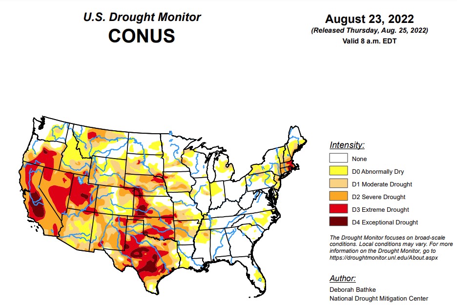
According to the latest U.S. drought monitor report, record-breaking rainfall led to aggressive improvements in drought conditions across parts of the South. The heavy rainfall and flooding led to communications outages at the National Weather Service office leaving climatologists without access to important data and tools needed to fully analyze the effect of this event. The magnitude of this event meant prioritizing improvements on this week’s map in these areas and in the Southwest, where the Monsoon season remains active. Drought expanded in the Northwest was warm, dry conditions continued across the region. The Midwest, Southeast, and Northeast saw a mix of improvements and degradations.
In the Southern Plains, this week’s storm event led to broad 1 and 2-category improvements across large parts of the South. All states in the region show improvements. Rainfall close to the data cut off time (Tuesday at 8:00 a.m. EDT), data communications issues caused by the flooding, and lags in the hydrologic system in response to rainfall events means that the full impact of this storm on drought conditions is not yet apparent. Analysis will continue next week as more data become available. A few impressive statistics include the following. According to National Weather Service records, prior to this week’s event, the Dallas-Fort Worth Area went 67 days without measurable precipitation, the second longest streak on record going back to 1898. The August 21-22, 24-hour total of 9.19 inches tied for the second highest 24-hour total. The Texas State Climatologist noted that the largest flood control rain gauge total was 15.16 inches!
In the High Plains, warm, dry conditions continued across the region. Moderate drought (D1) expanded in western South Dakota and northeast Wyoming where rainfall deficits of near 3 inches over the last 90 days dried out soils, lowered streamflow, and stressed vegetation. Additional analysis across the High Plains next week is likely to result in increasing drought severity across parts of the region due to persistent dry weather.
In the West, an active monsoon season in the Southwest led to improvements to drought conditions. Precipitation has improved many drought indicators including soil moisture, streamflow, and well data. Moderate drought (D2) improved in northern and southern Arizona. Moderate (D2) and extreme (D3) drought improved in southern and eastern New Mexico. Extreme drought (D3) improved in Utah and Nevada. Additional improvements are expected next week as the effect of the recent rainfall continues to be analyzed. To the north, Idaho and Montana saw an expansion to abnormally dry areas. Persistent warm, dry weather is likely to lead to additional degradations as soils continue to dry and vegetation suffers.
To view the contiguous U.S. drought map, click here.
Looking ahead, the National Weather Service Weather Prediction Center (valid August 25 - August 28) calls for rainfall over parts of the South, the Southwest, the Northern Rockies, Upper Midwest, and Northeast. Meanwhile, dry weather is expected to continue across the drought-stricken areas of the Pacific Northwest, California, the Central Great Basin, and Central Plains. Moving into next week (valid August 30 - September 1), the forecast calls for more rain across Texas, Oklahoma, and much of the eastern half of the CONUS. At 8 - 14 days, the Climate Prediction Center Outlook (valid September 1 - September 7) calls for above normal temperatures across the West, High Plains, Upper Midwest, East Coast, and interior Alaska. Below normal temperatures are predicted across southeast New Mexico, Texas, and Southern Oklahoma. Below normal precipitation is favored across much of the northern tier of CONUS. Above normal precipitation is favored for the southern tier, from New Mexico eastward.
To view the 6-10-day precipitation outlook map, click here.
To view the 6-10-day temperature outlook map, click here.
To view the monthly drought outlook map, click here.
WebReadyTM Powered by WireReady® NSI
Top Agricultural News
More Headlines...


