

Agricultural News
Oklahoma Drought Monitor Shows a Substantial Decrease in Exceptional Drought and Extreme Drought or Worse Since Last Week
Thu, 27 Oct 2022 09:53:12 CDT
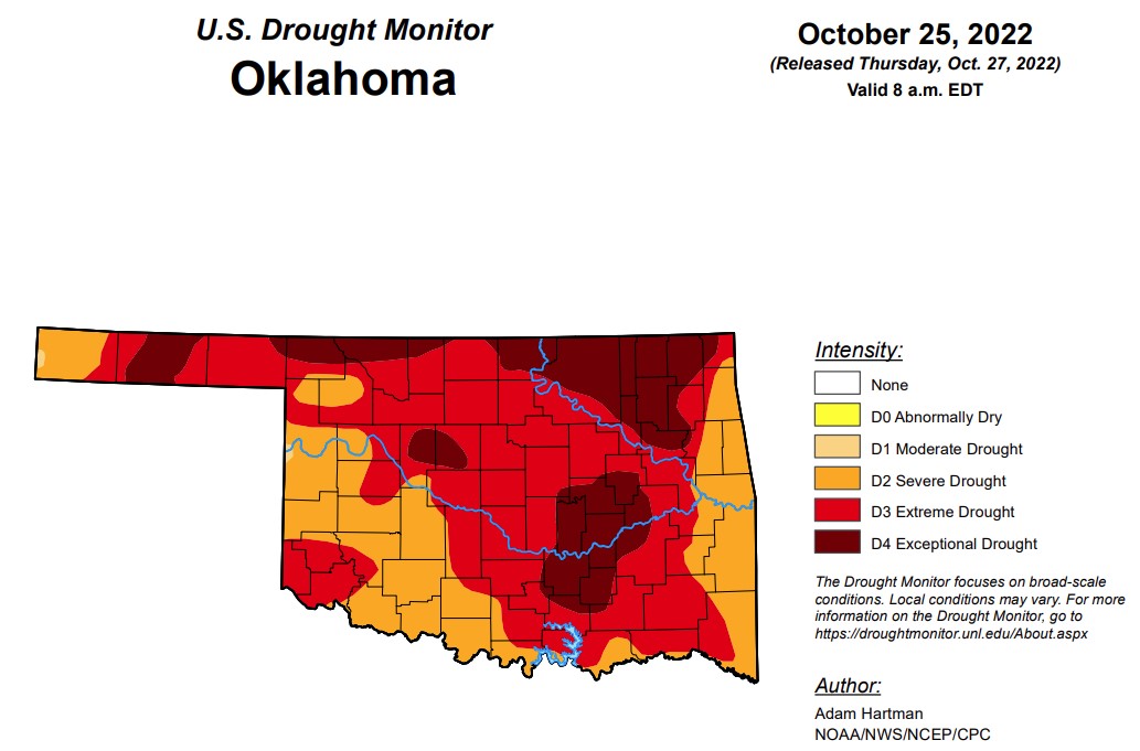 After recent rainfalls, significant improvements have been seen in both exceptional drought and extreme drought categories. According to the Oklahoma Mesonet, another big storm system is predicted to move in from the west next week across the Southern Plains.
In Oklahoma, exceptional drought is at 21 percent, down from last week’s 29.7 percent.
Extreme drought or worse is now at 70.2 percent, down over 10 percentage points from last week’s 82.2 percent.
Severe drought or worse is unchanged from last week at 99.8 percent.
Moderate drought or worse and abnormally dry or worse conditions remain unchanged from last week at 100 percent.
According to the 6-10-day precipitation map for Oklahoma through November 5, all but the Southeastern corner of the state is likely above 50 to 60 percent of precipitation. The Southeastern part of the state shows is leaning above a 40 to 50 percent chance of rain.
To view the Oklahoma Drought Map, click here.
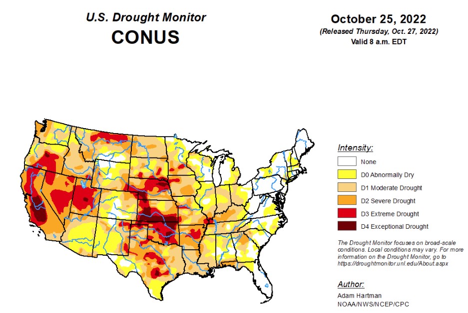
According to the latest U.S. Drought Monitor Report, a large shift in the weather pattern occurred this week across the lower 48 states. Early in the week, low pressure exited the Great Lakes region, allowing temperatures to gradually moderate during the latter half of the week across portions of the eastern contiguous U.S. (CONUS). In the western CONUS, high pressure broke down as a strong storm system moved into the Pacific Northwest heading into the weekend. As this storm system moved eastward into the Great Plains through the weekend and leading up to Tuesday, October 25, many locations across the western and central CONUS experienced above-normal precipitation, with cooler than normal temperatures in the system’s wake. However, with surface high pressure early in the week followed by southerly flow ahead of the storm system, warm temperatures dominated much of the central CONUS for the week as whole, with above-normal average temperatures also extending northeastward into the Great Lakes and Northeast. Unfortunately, given the expanse of drought and abnormal dryness across the U.S., antecedent dryness led to another week of degradations for many not receiving rainfall, even in areas where temperatures were cooler than normal this week. Warm conditions and high winds further exacerbated conditions in drier areas across the Great Plains. Fortunately, in areas seeing the heaviest rainfall amounts, particularly across the Southern Plains and Ozarks, some improvements were also warranted.
To view the United States Drought Monitor Report, click here.
In the Southern Plains, a storm system moving out of the Rockies and intensifying across the Southern Plains dropped in excess of 2 inches of rainfall in a large swath from northeastern Texas to the western Ozarks, warranting 1-category improvements across many of these locations. In surrounding areas that received heavier precipitation amounts, improvements were more targeted in nature, as amounts were not enough to eliminate 90-day deficits. Farther eastward, from the Lower Mississippi Valley to the Tennessee Valley, antecedent dryness and a drier than normal week resulted in another round of widespread 1-category degradations.
In the High Plains, above-normal temperatures, below-normal precipitation, and periods high winds resulted in degradations to ongoing D1 (moderate) to D4 (exceptional) drought across the Central Plains, east of the Front Range. Stock ponds for cattle remain low to non-existent and pastures are providing marginal feed, with supplemental feed required for many. Conversely, the storm system that moved across the Intermountain West during the weekend dropped heavy precipitation across the higher elevations of Wyoming and Colorado and parts of the Northern High Plains from Montana eastward to North Dakota. Unfortunately, even though several areas experienced in excess of 1 inch of precipitation (greater than 1.5 inches for many locations across the Northern High Plains), short to long-term drought indicators did not show many signs of improvement by Tuesday, October 25. Only surface soil moisture showed some improvement, with sparse 7-day average stream flows also improving, corroborated by ground reports. As such, given the lack of response in the indicators, much of the Northern High Plains remain unchanged this week.
In the West, a strong storm system moved into the western U.S. heading into the weekend and moved across the Intermountain West leading up to Tuesday, October 25. Many locations across the Pacific Northwest, Great Basin, and the Rockies received in excess of 0.5 inches of rainfall, with the heaviest amounts (greater than 1 inch, with locally higher totals) concentrated across the Pacific Northwest, Idaho, and Montana. Precipitation was not enough to improve drought conditions in the Pacific Northwest but was enough to halt another week of degradation along the windward slopes of the Cascades and Coastal Ranges. Only areas east of these ranges, in the rain shadows, experienced some targeted degradations. Farther south, D2 (severe) drought degraded to D3 (extreme drought) north of San Francisco, where USGS 28-day average stream flows have fallen below the 2nd percentile of the historical distribution, CPC soil moisture indicates D4-equivalent (exceptional drought) conditions, and the long-term objective drought blend depicts D3 conditions. Elsewhere, localized and targeted improvements were made across the Intermountain West, based on 7-day precipitation totals and improvements short-term precipitation deficits.
Looking ahead, During the next five days (October 27-31), the storm system that brought heavy rainfall to parts of the Southern Plains will bring rainfall to parts of the eastern Great Lakes and Northeast before exiting the U.S. The pattern will remain active across the remainder of the CONUS. However, much of the precipitation potential will be across the Southern Plains, extending eastward across parts of the Deep South, associated with a low pressure system that is forecast to intensify over the Southern Plains by the weekend before moving eastward through the remainder of the week. The Pacific Northwest is also expected to remain active through Monday, October 31. Additionally, near to below-normal temperatures are expected across the West Coast and much of the Southern Tier of the CONUS, along the predicted storm track. Farther north from the Northern Plains to the Northeast, predominantly above-normal temperatures are forecast due to a lesser influence from the storm track farther south.
The Climate Prediction Center’s 6-10 day outlook (valid November 1-5) predicts increased chances of below-normal temperatures and above-normal precipitation across the western half and two-thirds of the CONUS, respectively, associated with mean mid-level low-pressure. Meanwhile, mid-level high pressure favors above-normal temperatures from the Great Plains to the East Coast and drier than normal conditions from the Mississippi Valley eastward. In Alaska, a southerly storm track favors predominantly above-normal precipitation and is forecast to keep temperatures cooler than normal.
To view the 6-10 Day Precipitation Outlook Map, click here.
To view the 6-10 Day Temperature Outlook Map, click here.
To view the Monthly Drought Outlook Map, click here.
WebReadyTM Powered by WireReady® NSI
Top Agricultural News
More Headlines...


