


Agricultural News
Eastern Oklahoma Records Abundant Rainfall- Parts of Western Oklahoma Left High and Dry
Mon, 25 Apr 2011 6:07:45 CDT
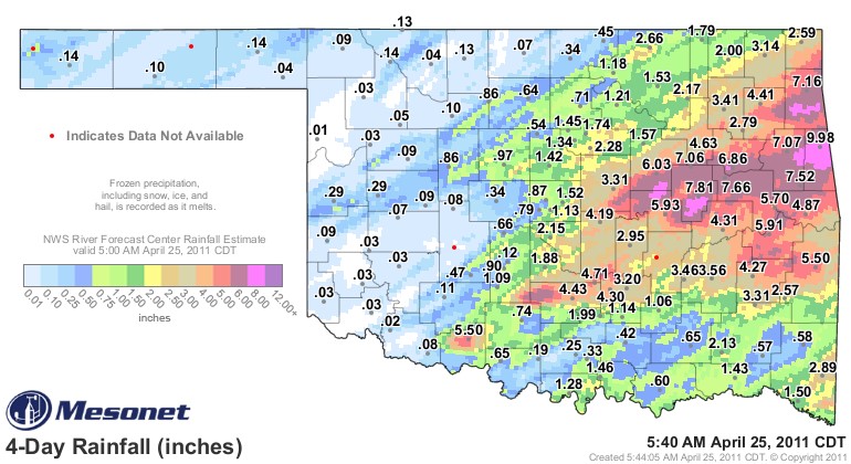 Easter's Weekend Rainfall event has dumped large amounts of precipitation on large areas of eastern Oklahoma, while central and western counties have received much less. Amounts of over two inches of rain are very common east of Interstate 35, while the largest rainfall recorded since the end of last week appears to be in Adair County with 9.97 inches of rainfall.
The current rain event may not be over as of yet. According to the News on 6 website, "Severe storms are in the forecast as very strong jet stream winds from the west combine with moisture from the south over the next few days, according to News On 6 meteorologist Dick Faurot.
"A few severe storms will also be possible on Sunday, but the greater chance will likely be on Monday," Faurot said.
"That is when we expect the surface front to drift far enough north to put most of us back into the warm sector with gusty southerly winds and a more unstable atmosphere creating a more favorable environment for all modes of severe weather."
Along the I-35 corredor, good rainfall has been reported, but in more moderate amounts. Garvin Cunty had a big Mesonet rain gauge number of 4.43 inches, while McClain, Cleveland, Oklahoma and Logan Counties all had rainfall totals in excess of an inch.
Cotton County is reporting the most rainfall west of I-35, with 5.5 inches of rain, but the reports we received from Friday night is that included a lot of hail. Jim Kinder of Walters reports on their farm the hail covered the ground and had a lot of stones that were super sized golf balls.
We have the Mesonet Map here that shows the rain amounts statement as of early Monday morning- stretching back for the past four days, when this system first started kicking up.
Current forecasts show that Western Oklahoma has the best chance at rain on Tuesday evening into Wednesday. Clear weather seems to follow that next system for at least a few days.
WebReadyTM Powered by WireReady® NSI
Top Agricultural News
More Headlines...


