


Agricultural News
Exceptional Drought Edges Further East in Latest Drought Monitor
Fri, 05 Aug 2011 06:06:47 CDT
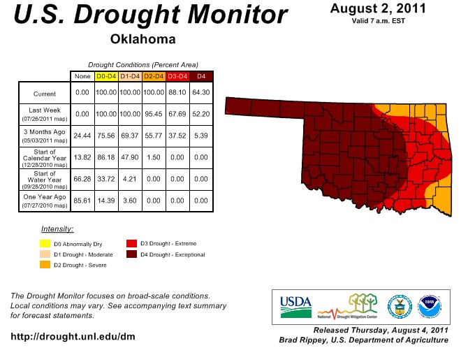 Almost two thirds of Oklahoma is now in the worst category for drought conditions- "D4" or Exceptional Drought. That's up by about 12 percetnage points from one week ago- as the hot dry summer conditions are quickly pushing the drought conditions further east. A total of 88% of the state is now in the extreme or exceptional drought category- and with most of August still in front of us- that number could come closer and closer to 100% before Labor Day.
Meanwhile, the big picture does not look good- as the long-range sea surface temperature computer models and atmospheric conditions are pointing more and more towards another possible La Nina event for this winter. Those factors and others have prompted the National Weather Service's Climate Prediction Center to issue a La Niña watch. Remember, La Niña CAN (not DOES) mean a warmer and drier than normal winter in Oklahoma with a jet stream/storm track pushed farther to the north. A La Niña watch is issued when conditions are favorable for the development of La Niña conditions within the next six months.
"Beyond the early fall, the forecasts are less certain with half of the models persisting neutral conditions continuously through early 2012. Along with a few other models, the latest runs from the NCEP Climate Forecast System (CFS) models predict La Niña to re-develop during the fall. This forecast is also supported by the ongoing La Niña-like tropical atmosphere, subsurface temperature trends, and the historical tendency for significant wintertime La Niña episodes to be followed by relatively weaker La Niña episodes the following winter. Therefore, neutral conditions are expected to continue into the Northern Hemisphere fall 2011, with neutral or La Niña equally likely thereafter."
This is particularly bad news for the Southern Plains and Oklahoma since another drier-than-normal cool season could result. Last winter's La Niña was a primary factor in the development and persistence of the current drought and was timed perfectly to devastate the 2011 wheat crop. Another such episode would not be welcomed by agricultural producers, to say the least. The resulting U.S.
precipitation forecasts give a hint of the possible dryness if La Niña does in fact return.
Gary McManus, Associate State Climatologist with the Oklahoma Climatological Survey puts the La Nina watch in perspective- "Even if the dryness was not significant, ANY hint of drier than normal weather is terrible news given the state of the current drought. The statewide average rainfall total of 16.57" since October 1, 2010, is nearly 14" below normal and the driest such period on record in Oklahoma since records began in 1895.
"Let's cut to the chase. A return to La Nina is not certain. If it does happen, it's not a guarantee of a continuation of drought, just an increased likelihood.
Other climate factors can have a say. However, it bears watching."
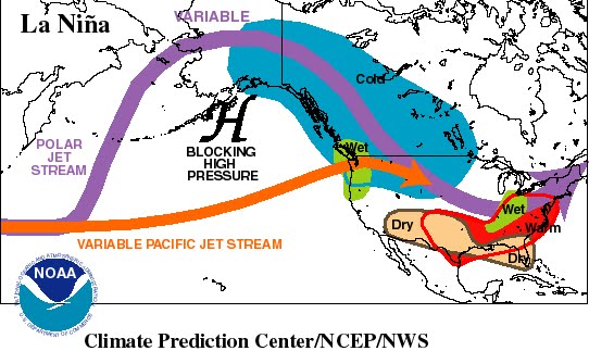
The top graphic is of the latest Drought Monitor- the bottom graphic shows a typical weather pattern that happens with a La Nina in place in the Pacific Ocean
WebReadyTM Powered by WireReady® NSI
Top Agricultural News
More Headlines...


