


Agricultural News
Major Rainfall Bands Shown On Mesonet Graphic- Check Them Out
Tue, 22 Nov 2011 07:47:01 CST
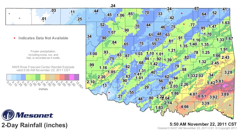 Flooding in southeastern Oklahoma has come with this latest round of showers, but no violet storms have been noted with this widespread rain event at the beginning of Thanksgiving week 2011. The far northwestern part of the state got little rain from this system- and the Panhandle got virtually nothing- but other areas that are still rated in "exceptional" or "extreme" drought got significant amounts of rain.
These rains may or may not be reflected in this week's Drought Monitor, but the land area covered by the highest levels of drought will likely continue to shrink over the next couple of weeks with this rain.
The graphic above shows the three major bands of rain that developed and dumped over six inches of rain in southeastern Oklahoma. Harmon County in southwestern Oklahoma also received a big boost in their efforts to roll back the drought, with more than two inches of rain recorded in the southwestern corner of the state. Southwestern Oklahoma producers are also hoping that this latest rainfall helped with some refilling of Altus Lugert Lake, which current is only at 17% of capacity.
Click here for our Oklahoma Weather page- which offers you News9 and News on 6 Weather- as well as links to the Mesonet and the National Weather Serv
WebReadyTM Powered by WireReady® NSI
Top Agricultural News
More Headlines...


