


Agricultural News
Major Rainfall Event Helps Oklahoma Drought Conditions
Tue, 08 Nov 2011 06:12:49 CST
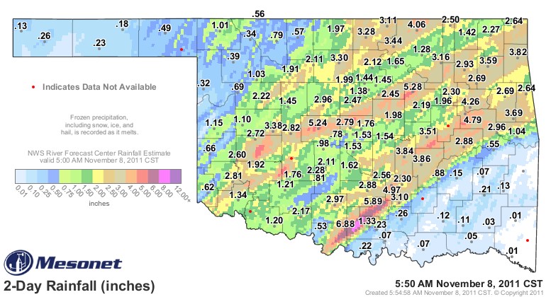 Oklahoma's drought may not be totally over- but a significant dent in the drought has happened with this latest outbreak of rains. The top graphic comes from the Oklahoma Mesonet as of early Tuesday morning, November 8, 2011- showing large areas of Oklahoma receiving rainfall totals over two inches.
The latest Drought Monitor is the graphic below- and it shows almost all of the state was still considered to be in "severe" drought as of November first- but the next couple of Drought Monitor updates may show that starting to finally shrink.
Southwestern Oklahoma had a tornado tear through the countryside- going from near Tipton up into the Wichita Mountains and finally wrap up around Ft. Cobb. KWTV's News9 helicopter was in the air- and has some amazing video- which you can see by clicking on the video window below. SkyNews9 captured video of a large tornado on the ground near the Blue Canyon Wind Farm northwest of Lawton.
At times it was a large wedge tornado. At other time, viewers could see several smaller stovepipe tornadoes touching down.
Apparently, the storm destroyed the Ft. Cobb Mesonet station, which is next to the OSU Experiment Station farm adjacent to the lake.
WebReadyTM Powered by WireReady® NSI
Top Agricultural News
More Headlines...


