


Agricultural News
Is Oklahoma in the Midst of Flash Drought Development?
Thu, 24 May 2012 11:11:03 CDT
Associate State Climatologist Gary McManus looks at the data from the Oklahoma Mesonet and asks the question: "Is Oklahoma in the midst of a flash drought development. Here is his analysis:
In my opinion, that is exactly what we are seeing as exceedingly dry, warm and windy weather continues. A flash drought is exactly what its name implies -- a more rapid development of drought (monthly time scale) as compared to its normal time scale (seasonal). The distinction is very much akin to the difference between river flooding and flash flooding ... the time scale is the key.
The development of flash droughts normally occurs during the summer months, but in reality our warmth started early this year. We are well on our way to seeing the records for warmest January-May and March-May (spring) periods absolutely shattered.
All the necessary ingredients have been added to the mix for rapid onset of drought: lack of rainfall mixed with hot weather and lots of sunshine (at a time when the energy from the sun is nearing its peak for our part of the world). The impacts of those ingredients are accelerated by the windy conditions, the advanced growth of vegetation, as well as the stress placed on the environment by last year's devastating drought.
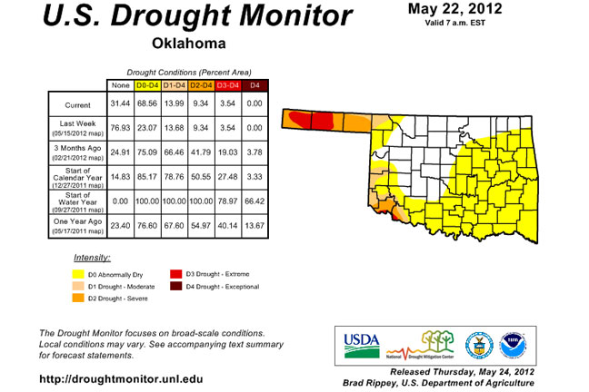
Accordingly, the U.S. Drought Monitor has begun to reflect the developing dryness with a large increase in its "abnormally dry" (D0) designation acrossmuch of southern and eastern Oklahoma.
Keep in mind that this is not a full-fledged drought designation, but the precursor to drought, described the Drought Monitor as an area "Going into drought: short-term dryness slowing planting, growth of crops or pastures."
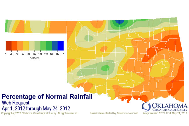
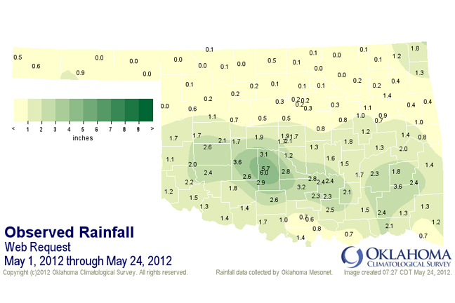
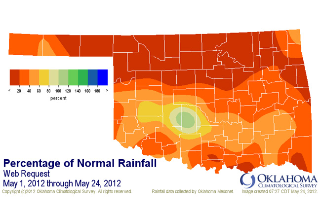
The tabular statistics indicate that Oklahoma saw a 46% increase in D0 from last week to this week, with 69% of the state now under some level of dry designation. The areas already in a full drought designation (D1-D4) remained at 14%. Those areas are also prone to rapid drought intensification. The newly designated D0 area matches up with the areas of highest rainfall deficits sincethe beginning of April.
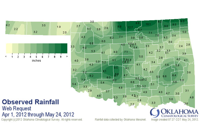
East Central (4.06 inches below normal) and southeastern Oklahoma (-4.92 inches) are experiencing their fifth- and fourth-driest April 1-May 24 periods on record, respectively.
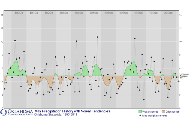
The state is currently on pace to have one of its driest Mays on record, dating back to 1895. The current statewide average rainfall, as of May 24, is 1.19 inches according to data from the Oklahoma Mesonet. The driest May on record for the state occurred in 1988 with a total of 1.3 inches. In comparison, that year saw the development of a fairly significant and damaging summer drought.
North central Oklahoma has had an average of 0.12 inches of rain in May thus far, 3.55 inches below normal and the driest such period on record for that part of the state. Only a smaller area based around Caddo and Grady Counties have had a decent amount of rainfall during the month.
That area is still surviving on the generous rainfalls it received at the end of April, although the wind and heat had begun to diminish that moisture from the soil as well.
Oklahoma is not alone in the increasing dryness. The same types of conditions are currently creeping across much of the Plains to the mid-South, from Kansas and Oklahoma through Arkansas, Missouri, Illinois, Kentucky and Tennessee.
Stress to crops, pastures and water supplies are increasing across those areas. The next decent chance for rain appears to be next week, so Oklahomans should look to that period for relief. The weather patterns can change rapidly this time of year. We are still within our normal wettest part of the year through at least mid-June.
There is no "flash drought warning" like there is for "flash flooding." However, the addition of such a large area of D0 in the Drought Monitor, not only for Oklahoma but for much of the mid-South, should serve as that type of warning.
WebReadyTM Powered by WireReady® NSI
Top Agricultural News
More Headlines...


