


Agricultural News
Oklahoma Rainfall Chances Ramp Up As Weekend Nears- Graphics and Video Available
Thu, 23 Aug 2012 06:15:27 CDT
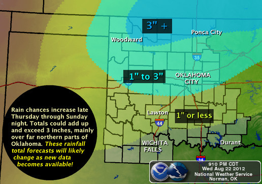 Predicted rainfall amounts in the northern half of the state look pretty good as we approach the last weekend of August- so says Gary England with News9, KWTV. Gary says that amounts one inch or more could occur from I-40 northward on Friday and into Saturday. The National Weather Service map shown above is even more generous for some northern Oklahoma counties along the Kansas border- talking three inches of rain as a possibility.
Click on the play button in the video box below to check out the weather forecast provided by Gary England on Thursday evening. Below the video box- we have Alan Crone's take from the News on Six as of early this Thursday morning.
News9.com - Oklahoma City, OK - News, Weather, Video and Sports |
"The weather today will feature another afternoon of mostly sunny, windy and warm conditions with highs in the mid-90s. The fire danger will continue to be high today before a storm system will approach the region this weekend with rain and storm chances. A red flag warning is underway for the counties just north of the Tulsa area. A few storms will be likely this afternoon across Western OK and will move eastward with time approaching the I-35 area Friday morning. The NSSL 4k hi res model indicates the possibility of a small cluster of storms approaching the Osage county area by 7AM Friday. Friday afternoon into the evening hours a few showers or storms may be possible near NE OK and SE Kansas.
"The upper air pattern will change today and tomorrow from a northwest flow to more of a west to southwest flow aloft. This will allow a storm system currently near the four corners area to slide eastward to central Kansas by this weekend. Some showers and storms will be likely this weekend across central and eastern OK but the overall coverage remains somewhat problematic. The EURO continues to support a nearly 100% coverage of moderate rainfall both Saturday and Sunday across northeastern OK while the NAM is a little more scattered, with not nearly as high as precipitation totals for the area. The GFS is somewhere in-between, and probably offers the best shot at verification for this package. I would love to forecast the EURO solution which would keep the highs near the upper 70s Saturday with some much needed rainfall for most of our area. At this point, we'll be increasing our probabilities near 60%. Regarding the severe weather potential: we currently do not think significant severe weather will be likely. There may be a few rouge severe storms, but the overall coverage would be low."
WebReadyTM Powered by WireReady® NSI
Top Agricultural News
More Headlines...


