


Agricultural News
Rainfalll Wanted- Rainfall Headed Our Way- Check the Forecast Map
Tue, 08 Jan 2013 05:33:07 CST
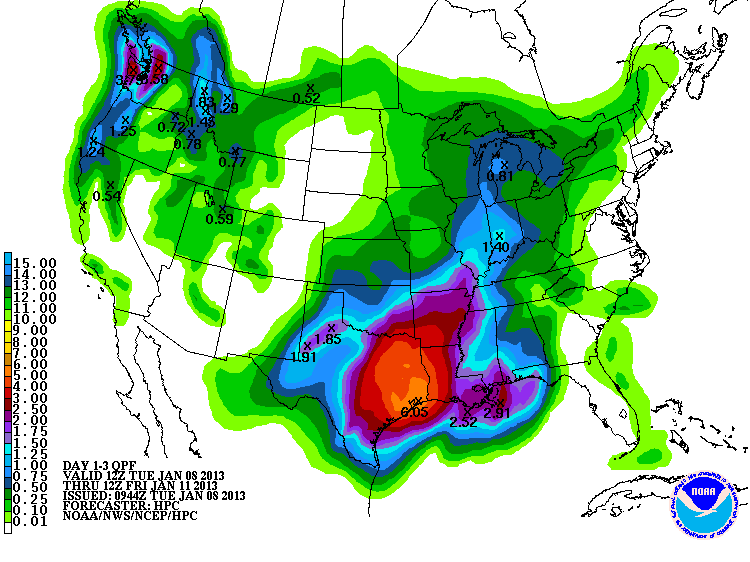 Rainfall appears to be on its way into the state of Oklahoma. According to Gary McManus, the forecast models have flirted a bit lately with taking out delicious-looking rain totals farther to the south. Points south and east of Oklahoma probably will get the more generous totals, but that still leaves from 1-2" for our neck of the woods. The graphic above shows the forecast amounts for the from now through the end of the week.
McManus adds in his Mesonet Ticker that "Southeast Oklahoma could get more than 3 inches, which would put them in drought improvement territory. We'll watch those lakes and ponds down there and see if they respond at all. Even the Panhandle is slated to get from a quarter to possible three-quarters inches of moisture, which would be fantastic."
Michael Grogan from the News on 6 in Tulsa agrees that this system should be a real rainmaker. Grogan explains in a blog posted in the weather section of the news on 6 website that this is a system that is coming up from old Mexico. He writes "Due to the compact nature of this system, the bulk of the heavy rain will be closer to its center, initially to the south of the Red River. Outside of a few showers late in the day, Tuesday should be dry. On Wednesday, that rain shield will spread north into Oklahoma and bring widespread rainfall to the region. Embedded thunderstorms are also possible Wednesday night."
"Since this system dives so far south, it doesn't tap into any Arctic (or even modestly cold) air. Therefore, wintry weather is not a concern for us. A different scenario will play out this weekend where moisture may be lacking, but the Arctic chill won't be. A strong cold front will sweep through Oklahoma Saturday, allowing temperatures to go from the 60s on Friday, to the 30s for highs by Sunday. It'll be a nice, but brief reprieve from winter. From there, the pattern suggests the cold air settles in the central U.S. for quite awhile as a sustained trough in the jet stream sets up. Mid-January may bring us some of the coldest air of the season." ( Click here for his complete blog entry on this week's rain event. )
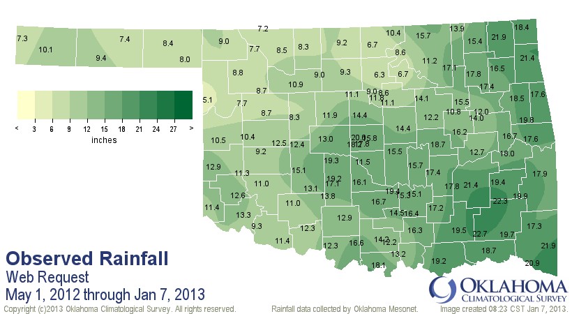
Meanwhile- looking at rainfall we have had across Oklahoma up to this point- the graphic below offers a historic perspective of what has happened since the first of May last year and explains why much of the state is in extreme to exceptional drought.. This has been the driest of all May 1- January 7 periods dating back to 1895, with a statewide average of 13.48", nearly 14" below normal.
WebReadyTM Powered by WireReady® NSI
Top Agricultural News
More Headlines...


