


Agricultural News
Latest Drought Monitor Graphic- Take a Look
Fri, 04 Jan 2013 05:01:52 CST
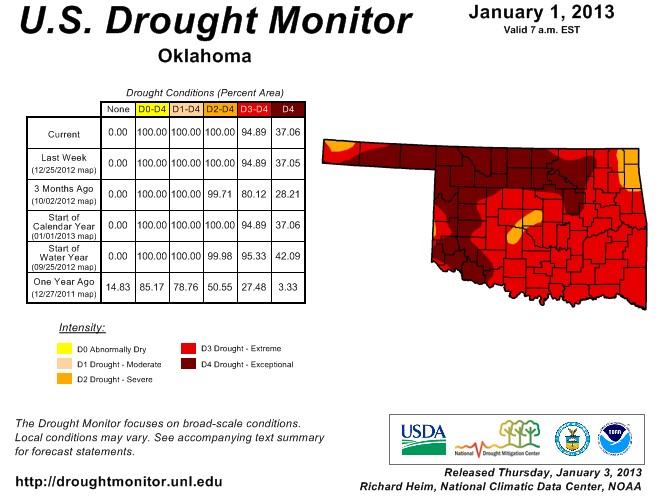 Drought Conditions as reflected by the latest Drought Monitor report shows no change across Oklahoma in the latest week- even with some rainfall that happened in the final hours of the old year. That moisture may be reflected in the next monitor that will be released next Thursday. The graphic above shows the latest Drought Monitor for Oklahoma, which shows that the state remains in extreme to exceptional drought across 95% of the state.
Nationally- the worries continue as well. Despite some recent storms - much of the U.S. still needs relief from the longest dry spell the nation has seen in decades. According to experts - it will take a great deal of snow to ease the woes of farmers and ranchers. More than 15-inches of snow have fallen on parts of the Midwest and East in recent weeks - but climatologists say it's going to take at least eight-feet of snow to return the soil to its pre-drought condition in time for spring planting. Water levels on the Mississippi River are dropping and threatening to halt barge traffic south of St. Louis. Out West there is concern that a lack of snow could leave forests and fields primed for a repeat of the wildfire season of 2012 - when some 9.2-million acres burned. The lack of moisture is also a water concern. Many cities already have water restrictions - and snow and ice accumulation in the mountains during the winter is relied upon in western states for the majority of their freshwater needs during the year. Fortunately - climatologists say it's too early in the winter to give up hope. Some experts say it just takes the cooperation of one storm system to get back on track.
WebReadyTM Powered by WireReady® NSI
Top Agricultural News
More Headlines...


