


Agricultural News
Drought Busting Rainfall Numbers Have Piled Up in Portions of the Middle of Oklahoma- The Latest Graphic
Thu, 04 Apr 2013 04:56:56 CDT
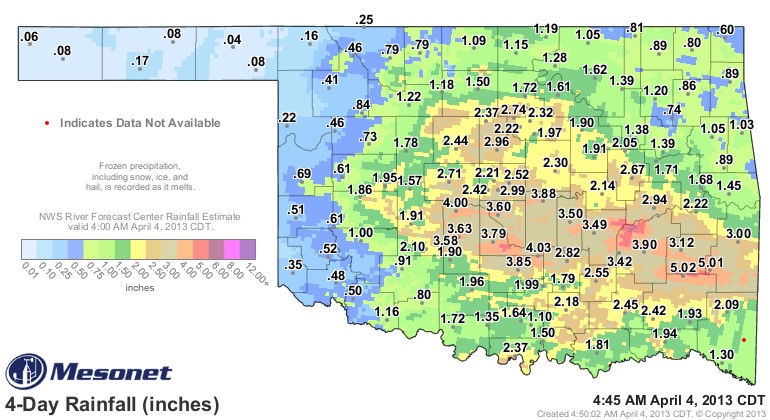 Rainfall totals continue to pile up across the middle of Oklahoma, with some light snow showing on radar in west of I-35 and rain persisting in east central Oklahoma as of early Thursday morning. The snapshot of rainfall as of 4:45 AM Thursday morning shows Clayton and Talihina both hitting five inches of rainfall this week- and another two Oklahoma Mesonet stations in central Oklahoma exceeding four inches of rain since Sunday morning through Thursday AM- and another twelve locations topping three inches of rain- with several of those in central Oklahoma.
The heaviest band of rainfall has set up from Bessie (along the Custer- Washita County line in western Oklahoma) where they have recorded almost two inches of rain this week and extends east to the Arkansas state line- following along just south of Interstate 40 for the heaviest of the rainfall totals.
The Oklahoma Panhandle and the western most counties in the state have had less rainfall in this stretched out event- but every Mesonet station in the state has recorded at least a fews hundreths of an inch of rain- the dubious honor of the least rainfall in this period rests with Beaver- they have recorded a paltry 4 hundreths of an inch of rain.
It remains to be seen if the next Drought Monitor will actually take some of eastern Oklahoma out of drought altogether later this morning- but that will be a distinct possibility by next week if it does not ocurr this week. The Drought Monitor readings that come out Thursday mornings reflect rainfall received through Tuesday of that week.
The graphic above is the rainfall totals for Thursday morning backward to Sunday morning- click here for an interactive realtime version of that same four day map.
WebReadyTM Powered by WireReady® NSI
Top Agricultural News
More Headlines...


